179.60.24.133 - IP Lookup: Free IP Address Lookup, Postal Code Lookup, IP Location Lookup, IP ASN, Public IP
Country:
Region:
City:
Location:
Time Zone:
Postal Code:
IP information under different IP Channel
ip-api
Country
Region
City
ASN
Time Zone
ISP
Blacklist
Proxy
Latitude
Longitude
Postal
Route
Luminati
Country
Region
s
ASN
Time Zone
America/Argentina/Cordoba
ISP
Cooperativa Telefonica de V.G.G. Ltda.
Latitude
Longitude
Postal
IPinfo
Country
Region
City
ASN
Time Zone
ISP
Blacklist
Proxy
Latitude
Longitude
Postal
Route
IP2Location
179.60.24.133Country
Region
santa fe
City
rosario
Time Zone
America/Argentina/Cordoba
ISP
Language
User-Agent
Latitude
Longitude
Postal
db-ip
Country
Region
City
ASN
Time Zone
ISP
Blacklist
Proxy
Latitude
Longitude
Postal
Route
ipdata
Country
Region
City
ASN
Time Zone
ISP
Blacklist
Proxy
Latitude
Longitude
Postal
Route
Popular places and events near this IP address

Palacio de los Leones
Municipal building in Rosario, Argentina
Distance: Approx. 701 meters
Latitude and longitude: -32.9471,-60.6322
Palacio de los Leones (Spanish, Palace of the Lions) is the name of the main municipal building of the city of Rosario, Argentina. The Palace is the seat of the executive branch of the municipal government. It is located at the corner of Buenos Aires and Santa Fe Streets, in front of Plaza 25 de Mayo (May 25 Square), and separated from the Cathedral by the promenade known as Pasaje Juramento (Oath Passage), which leads to the National Flag Memorial.

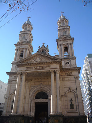
Cathedral Basilica of Our Lady of the Rosary
Roman Catholic cathedral in Rosario, Argentina
Distance: Approx. 717 meters
Latitude and longitude: -32.94758056,-60.63208056
The Cathedral Basilica Shrine of Our Lady of the Rosary is a minor basilica and cathedral dedicated to the local Virgin of the Rosary, in the city of Rosario, province of Santa Fe, Argentina. It is the mother church of the Archdiocese of Rosario. The basilica is located on the oldest part of the city, at the corner of Buenos Aires St.

Roman Catholic Archdiocese of Rosario
Catholic ecclesiastical territory
Distance: Approx. 696 meters
Latitude and longitude: -32.9475,-60.6323
The Roman Catholic Archdiocese of Rosario (Latin: Archidioecesis Rosariensis) is an ecclesiastical territory or diocese of the Roman Catholic Church in the southern part of the province of Santa Fe, Argentina, with its mother church, the Basilica Cathedral of Our Lady of the Rosary, located in the city of Rosario. The Archbishop since 22 December 2005 is José Luis Mollaghan and the Auxiliary Bishop was Sergio Fenoy, until he was appointed Bishop of San Miguel the 5 December 2006. The former archbishop Eduardo Mirás served as Apostolic Administrator of the Archdiocese between 22 December 2005 and 18 March 2006, the date that Msgr.

Firma y Odilo Estévez Municipal Decorative Art Museum
Distance: Approx. 617 meters
Latitude and longitude: -32.9466,-60.6331
Firma y Odilo Estévez Municipal Decorative Art Museum (in Spanish, Museo de Arte Decorativo Firma y Odilo Estévez) is the former home of the Estévez family in Rosario, Argentina, which was donated to the Municipality of Rosario and turned into a museum. Mrs. Firma Mayor de Estévez bequeathed her mansion and its contents to the city, in memory of her husband Odilo Estévez.

San Martín Street (Rosario)
Street in Rosaria, Argentina
Distance: Approx. 280 meters
Latitude and longitude: -32.9467,-60.6367
San Martín Street is an important street in Rosario, Santa Fe Province, Argentina. It runs north–south through the center of the city, from the coastal avenue by the Paraná River to the southern limit of the urbanized area (a total of 6.5 km). It was originally named Calle del Puerto ("Port Street"); the name was changed in 1887 to honour Independence War hero General José de San Martín.

Plaza 25 de Mayo (Rosario)
Distance: Approx. 606 meters
Latitude and longitude: -32.94712,-60.633228
Plaza 25 de Mayo ("May 25 Square"; Spanish: [ˈplasa βejntiˈsiŋko ðeˈmaʝo]) is a plaza (urban square) in Rosario, province of Santa Fe, Argentina. It is Rosario's civic center, and the core of the original settlement. Its name alludes to the date (25 May 1810) of the May Revolution, which led to the establishment of the first local Argentine government in Buenos Aires.

Plaza Pringles (Rosario)
Square in the city of Rosario, Argentina
Distance: Approx. 476 meters
Latitude and longitude: -32.945121,-60.644386
Plaza Pringles (Spanish for "Pringles Square") is a plaza (urban square) in Rosario, province of Santa Fe, Argentina. Its name is an homage to Colonel Juan Pascual Pringles, hero of the Spanish American wars of independence (who also gave its name to the Plaza Pringles located in the city of San Luis). Plaza Pringles occupies a half block in the downtown area of Rosario, beside the historical section of Córdoba St.

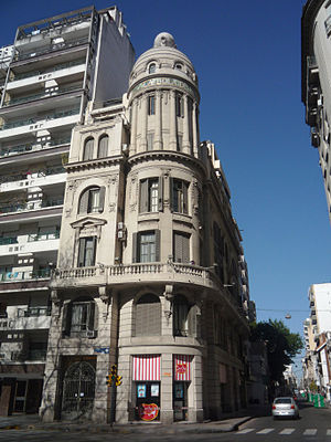
La Bola de Nieve
Distance: Approx. 570 meters
Latitude and longitude: -32.947534,-60.633658
La Bola de Nieve (Spanish, literally The Snowball) is a historical building in the city of Rosario, Santa Fe Province, Argentina. Its name alludes to the presence of a large stone sphere on its top. The building is located in the corner of Laprida St.

Plaza Sarmiento (Rosario)
Plaza in city of Rosario, Santa Fe, Argentina
Distance: Approx. 398 meters
Latitude and longitude: -32.94947,-60.642541
Plaza Sarmiento is a plaza (urban square) in the city of Rosario, province of Santa Fe, Argentina. Its name is an homage to former Argentine president Domingo Faustino Sarmiento. Plaza Sarmiento is located in a strategic location within the Rosario downtown area, and serves as a transport node for many urban and short-distance interurban bus lines.

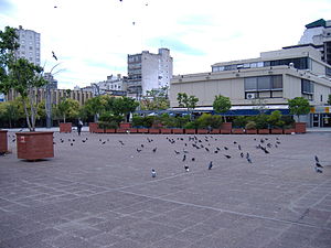
Plaza Montenegro (Rosario)
Distance: Approx. 348 meters
Latitude and longitude: -32.949479,-60.637777
Plaza Santiago Montenegro is a small hardscape plaza in the city of Rosario, province of Santa Fe, Argentina. Its name honors one of the first Spanish-descended settlers in the area, Captain Santiago Montenegro. It was known as Plaza Pinasco until 1993.

Palacio Cabanellas
Distance: Approx. 282 meters
Latitude and longitude: -32.949245,-60.638904
The Palacio Cabanellas (Spanish, Cabanellas Palace) is a historical building in the city of Rosario, province of Santa Fe, Argentina. It is located in the downtown area, occupying the southwestern corner of San Luis St. and Sarmiento St.

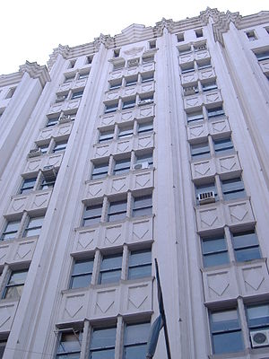
Palacio Minetti
Distance: Approx. 334 meters
Latitude and longitude: -32.945481,-60.642917
The Palacio Minetti (Spanish, Minetti Palace) is a building in Rosario, in Santa Fe Province, Argentina. It is located at one end of the pedestrian segment of Córdoba St., within the historical district known as Paseo del Siglo. The palace was projected in 1929 by the architects José Gerbino, Luis Schwarz and Juan Bautista Durand, who were commissioned by Domingo Minetti, a vegetable oil and mill industry businessman, for the design of new corporate headquarters for Minetti y Compañía.
Weather in this IP's area
clear sky
13 Celsius
13 Celsius
13 Celsius
14 Celsius
1014 hPa
90 %
1014 hPa
1010 hPa
10000 meters
2.24 m/s
110 degree