Country:
 Peru
PeruRegion:
City:
Latitude and Longitude:
Time Zone:
Postal Code:
IP information under different IP Channel
ip-api
Country
Region
City
ASN
Time Zone
ISP
Blacklist
Proxy
Latitude
Longitude
Postal
Route
IPinfo
Country
Region
City
ASN
Time Zone
ISP
Blacklist
Proxy
Latitude
Longitude
Postal
Route
MaxMind
Country
Region
City
ASN
Time Zone
ISP
Blacklist
Proxy
Latitude
Longitude
Postal
Route
Luminati
Country
PERegion
lal
City
trujillo
ASN
Time Zone
America/Lima
ISP
America Movil Peru S.A.C.
Latitude
Longitude
Postal
db-ip
Country
Region
City
ASN
Time Zone
ISP
Blacklist
Proxy
Latitude
Longitude
Postal
Route
ipdata
Country
Region
City
ASN
Time Zone
ISP
Blacklist
Proxy
Latitude
Longitude
Postal
Route
Popular places and events near this IP address

Amazonas (Peruvian department)
Departments of Peru
Distance: Approx. 2473 meters
Latitude and longitude: -6.22,-77.85
Amazonas (Spanish pronunciation: [amaˈsonas]) is a department and region in northern Peru bordered by Ecuador on the north and west, Cajamarca on the west, La Libertad on the south, and Loreto and San Martín on the east. Its capital is the city of Chachapoyas. With a landscape of steep river gorges and mountains, Amazonas is the location of Kuelap, a huge stone fortress enclosing more than 400 stone structures; it was built on a mountain about 3,000 meters high, starting about 500 AD and was occupied to the mid-16th century.
Chachapoyas, Peru
City in Amazonas, Peru
Distance: Approx. 2687 meters
Latitude and longitude: -6.21666667,-77.85
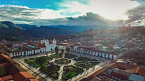
Chachapoyas (Spanish pronunciation: [tʃa.tʃaˈpo.ʝas]) is a city in northern Peru at an elevation of 2,335 meters (7,661 ft). The city has a population of 32,026 people (2017). Situated in the mountains far from the Peruvian coast, Chachapoyas remains fairly isolated from other regions of Peru.

Chachapoyas District
District in Amazonas, Peru
Distance: Approx. 2667 meters
Latitude and longitude: -6.21694444,-77.85
Chachapoyas District is one of twenty-one districts of Chachapoyas Province in Peru.

Huancas District
Distance: Approx. 6452 meters
Latitude and longitude: -6.17388889,-77.86472222
Huancas is one of the 21 districts of Chachapoyas Province in the Amazonas Region of northern Peru. It is bounded to the north by Valera District, to the east by Sonche District, to the south by Chachapoyas District, and to the west by Luya District and Lámud District.
Lonya Chico district
District in Amazonas, Peru
Distance: Approx. 5308 meters
Latitude and longitude: -6.23305556,-77.91694444
Lonya Chico is a district of the province of Luya, in the Amazonas region of Peru. Several ruins of the Chachapoya culture are located in the area. The capital of the district, also called Lonya Chico, celebrates the day of its patron saint, Saint Lucy, on August 15.
Santa Ana Church, Amazonas
Distance: Approx. 801 meters
Latitude and longitude: -6.2263,-77.8738
Santa Ana Church (Spanish: Iglesia de Santa Ana de Chachapoyas)is located in the first block of Chincha Alta street, opposite to the Saint Ana's square. It was the first church of its type, constructed by the Spanish in 1569 in what is now the Department of Amazonas, Peru. In 2009, the church, which had been abandoned for years, was inaugurated as an ethnohistorical-religious museum.

Señor de Burgos Church, Amazonas
Church in Chachapoyas, Peru
Distance: Approx. 305 meters
Latitude and longitude: -6.2298,-77.867
The Señor de Burgos Church is a 17th-century adobe built church located on Plaza de la Independencia in the La Laguna quarter of Chachapoyas, capital of the Amazonas Region of Peru. Señor de Burgos is a venerated local figure to whom is attributed a number of miracles. During its history, it has suffered as the result of several earthquakes, notably in 1929, 1970 and 2005, which have cause changes to the building's structure and appearance.
Higos Urco pampa
Distance: Approx. 1682 meters
Latitude and longitude: -6.2287,-77.8541
Higos Urco pampa is a historical place in Chachapoyas, Peru where the battle of the same name was fought on 6 June 1821, before José de San Martín proclaimed Peruvian independence. In remembrance and commemoration of the battle, there is a small square raised.

Roman Catholic Diocese of Chachapoyas
Roman Catholic diocese in Peru
Distance: Approx. 441 meters
Latitude and longitude: -6.23,-77.8726
The Roman Catholic Diocese of Chachapoyas (Latin: Chachapoyasen(sis)) is a diocese located in the city of Chachapoyas in the ecclesiastical province of Piura in Peru.

Chachapoyas Airport
Airport in Peru
Distance: Approx. 3627 meters
Latitude and longitude: -6.20138889,-77.85694444
Chachapoyas Airport (IATA: CHH, ICAO: SPPY), is an airport serving the city of Chachapoyas in the Amazonas Region of Peru. The runway is on a mesa north of the city, with steep drop-offs on either end. The Chachapoyas VOR-DME (Ident: POY) is located on the field.

Chachapoyas Cathedral
Church in Chachapoyas, Peru
Distance: Approx. 451 meters
Latitude and longitude: -6.23,-77.8727
The Cathedral of St. John the Baptist in Chachapoyas (Spanish: Catedral de San Juan Bautista ), also called Chachapoyas Cathedral, is a parish of the Catholic Church and seat of the Diocese of Chachapoyas. The cathedral church is located on the main square of the city of Chachapoyas, the capital of the Department of Amazonas, Peru.

National University Toribio Rodríguez de Mendoza
Peruvian state-owned university
Distance: Approx. 1666 meters
Latitude and longitude: -6.233,-77.854
The National University Toribio Rodríguez de Mendoza (UNTRM) is a state-owned university in Chachapoyas, Peru. The UNTRM was founded on September 18, 2000.
Weather in this IP's area
overcast clouds
20 Celsius
19 Celsius
20 Celsius
20 Celsius
1017 hPa
55 %
1017 hPa
777 hPa
10000 meters
0.61 m/s
2.14 m/s
70 degree
98 %
05:48:37
18:04:06