179.6.115.113 - IP Lookup: Free IP Address Lookup, Postal Code Lookup, IP Location Lookup, IP ASN, Public IP
Country:
 Peru
PeruRegion:
City:
Location:
Time Zone:
Postal Code:
ISP:
ASN:
language:
User-Agent:
Proxy IP:
Blacklist:
IP information under different IP Channel
ip-api
Country
Region
City
ASN
Time Zone
ISP
Blacklist
Proxy
Latitude
Longitude
Postal
Route
db-ip
Country
Region
City
ASN
Time Zone
ISP
Blacklist
Proxy
Latitude
Longitude
Postal
Route
IPinfo
Country
Region
City
ASN
Time Zone
ISP
Blacklist
Proxy
Latitude
Longitude
Postal
Route
IP2Location
179.6.115.113Country
peRegion
tumbes
City
tumbes
Time Zone
America/Lima
ISP
Language
User-Agent
Latitude
Longitude
Postal
ipdata
Country
Region
City
ASN
Time Zone
ISP
Blacklist
Proxy
Latitude
Longitude
Postal
Route
Popular places and events near this IP address

Tumbes, Peru
Town in Tumbes, Peru
Distance: Approx. 2087 meters
Latitude and longitude: -3.57083333,-80.45972222
Tumbes is a city in northwestern Peru, on the banks of the Tumbes River. It is the capital of the Tumbes Region, as well as of Tumbes Province and Tumbes District. Located near the border with Ecuador, Tumbes has 111,595 inhabitants as of 2015.

Tumbes province
Province in Tumbes, Peru
Distance: Approx. 955 meters
Latitude and longitude: -3.5667,-80.45
Tumbes is a province in Peru, located in the region of the same name. It borders the Pacific Ocean on the north, the province of Zarumilla on the east, the Piura Region and Ecuador on the south and the province of Contralmirante Villar on the west. Its capital is Tumbes, which is also the regional capital.

Tumbes River
River in Peru and Ecuador
Distance: Approx. 8730 meters
Latitude and longitude: -3.49,-80.425
The Tumbes River (Spanish: Río Tumbes or Río Túmbez in Peru; Río Puyango in Ecuador), is a river in South America. The river's sources are located between Ecuadorian El Oro and Loja provinces. It is the border between El Oro and Loja, and afterwards the border between Loja and the Tumbes Region in Peru.
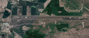
FAP Captain Pedro Canga Rodríguez Airport
Airport in Peru
Distance: Approx. 6822 meters
Latitude and longitude: -3.55138889,-80.38194444
Capitán FAP Pedro Canga Rodríguez Airport (IATA: TBP, ICAO: SPME) is an airport serving Tumbes, Peru. It is the main airport of the Tumbes Region, and is run by CORPAC S.A. (Corporación Peruana de Aeropuertos y Aviación Comercial S.A.), a government organization that manages Peruvian airports. The airport is used mainly by locals and national and international travelers because of its proximity to beaches and resorts.

Tumbes District
District in Tumbes, Peru
Distance: Approx. 955 meters
Latitude and longitude: -3.5667,-80.45
Tumbes is a district in the middle Tumbes Province in Peru. It is bordered by Corrales District on the west, Pacific Ocean on the north, Zarumilla Province on the east, and San Juan de la Virgen District on the south.

Corrales District
District in Tumbes, Peru
Distance: Approx. 5800 meters
Latitude and longitude: -3.601,-80.4807
Corrales District is one of the six districts of the province Tumbes in Peru.
San Jacinto District
District in Tumbes, Peru
Distance: Approx. 8443 meters
Latitude and longitude: -3.6422,-80.4486
San Jacinto District is one of the six districts of the province Tumbes in Peru.
San Juan de la Virgen District
District in Tumbes, Peru
Distance: Approx. 6829 meters
Latitude and longitude: -3.6275,-80.4332
San Juan de la Virgen District is one of the six districts of the province Tumbes in Peru.
Estadio Mariscal Cáceres
Distance: Approx. 1070 meters
Latitude and longitude: -3.5571,-80.4419
Estadio Mariscal Cáceres is a multi-use stadium in Tumbes, Peru. It is currently used mostly for football matches and is the home stadium of Defensor San José and Sporting Pizarro of the Copa Perú.
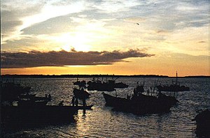
Puerto Pizarro
Distance: Approx. 9015 meters
Latitude and longitude: -3.502,-80.3926
Puerto Pizarro is a resort located thirteen miles from the city of Tumbes, Peru. Its inhabitants are mostly fishermen and seashell collectors.

St. Nicholas Cathedral, Tumbes
Church in Tumbes, Peru
Distance: Approx. 2265 meters
Latitude and longitude: -3.5701,-80.4615
The St. Nicholas Cathedral (Spanish: Catedral de San Nicolás ) also called Tumbes Cathedral Or Church of San Nicolás de Tolentino is the name that receives a temple affiliated and property of the Catholic Church located in the locality of Tumbes in the department of the same name to the north of the South American country of Peru. It is located specifically in the main square of Tumbes.
Cabeza de Vaca, Tumbes
Archaeological site in Peru
Distance: Approx. 6755 meters
Latitude and longitude: -3.60083333,-80.49166667
Cabeza de Vaca is an archaeological site in Peru. It is located in the Tumbes Region, Tumbes Province, Corrales District. Cabeza de Vaca was occupied by Incas.
Weather in this IP's area
broken clouds
28 Celsius
30 Celsius
28 Celsius
28 Celsius
1011 hPa
69 %
1011 hPa
1007 hPa
10000 meters
5.66 m/s
10 degree
75 %