Country:
 Peru
PeruRegion:
City:
Latitude and Longitude:
Time Zone:
Postal Code:
IP information under different IP Channel
ip-api
Country
Region
City
ASN
Time Zone
ISP
Blacklist
Proxy
Latitude
Longitude
Postal
Route
IPinfo
Country
Region
City
ASN
Time Zone
ISP
Blacklist
Proxy
Latitude
Longitude
Postal
Route
MaxMind
Country
Region
City
ASN
Time Zone
ISP
Blacklist
Proxy
Latitude
Longitude
Postal
Route
Luminati
Country
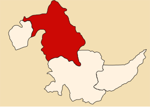
PERegion
uca
City
pucallpa
ASN
Time Zone
America/Lima
ISP
America Movil Peru S.A.C.
Latitude
Longitude
Postal
db-ip
Country
Region
City
ASN
Time Zone
ISP
Blacklist
Proxy
Latitude
Longitude
Postal
Route
ipdata
Country
Region
City
ASN
Time Zone
ISP
Blacklist
Proxy
Latitude
Longitude
Postal
Route
Popular places and events near this IP address

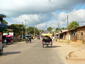
Pucallpa
City in Ucayali, Peru
Distance: Approx. 2810 meters
Latitude and longitude: -8.38333333,-74.55
Pucallpa (, Quechua: puka allpa, lit. 'red dirt'; Shipibo: May Ushin) is a city in eastern Peru located on the banks of the Ucayali River, a major tributary of the Amazon River. It is the capital of the Ucayali region, the Coronel Portillo Province and the Calleria District. This city is categorized as the only metropolis in Ucayali, being the largest populated center of the region.

TANS Perú Flight 204
2005 aviation accident
Distance: Approx. 8478 meters
Latitude and longitude: -8.41666667,-74.59583333
TANS Perú Flight 204 was a domestic scheduled Lima–Pucallpa–Iquitos passenger service, operated with a Boeing 737-200 Advanced, that crashed on 23 August 2005 on approach to Pucallpa Airport, 4 miles (6.4 km) off the airfield, following an emergency landing attempt because of bad weather, killing 40 of the 98 passengers and crew aboard.
Coronel Portillo Province
Province in Ucayali, Peru
Distance: Approx. 2811 meters
Latitude and longitude: -8.3833,-74.55
Coronel Portillo is the second largest of four provinces in the Ucayali Region in Peru. Its capital is Pucallpa.
FAP Captain David Abensur Rengifo International Airport
Airport in Pucallpa, Coronel Portillo, Ucayali, Peru
Distance: Approx. 5539 meters
Latitude and longitude: -8.37777778,-74.57416667
FAP Captain David Abensur Rengifo International Airport (IATA: PCL, ICAO: SPCL) (Spanish: Aeropuerto Internacional Capitán FAP David Abensur Rengifo) (also known as Captain Rolden International Airport) is an airport serving the city of Pucallpa in the Ucayali Region of Peru. It is operated by Aeropuertos del Perú, S.A. Captain Rengifo Airport is the main airport serving the Ucayali Region.
Yarinacocha District
District in Ucayali, Peru
Distance: Approx. 6834 meters
Latitude and longitude: -8.3538,-74.5768
Yarinacocha District is one of the seven districts of Peru in Coronel Portillo Province, part of the Ucayali Region. Its capital is the village of Puerto Callao.
Nueva Requena District
District in Ucayali, Peru
Distance: Approx. 7201 meters
Latitude and longitude: -8.3341,-74.562
Nueva Requena District is one of the seven districts of Peru in Coronel Portillo Province.
Manantay District
District in Ucayali, Peru
Distance: Approx. 5828 meters
Latitude and longitude: -8.43333333,-74.55
Manantay District is one of the seven districts of Peru in Coronel Portillo Province.
Callería District
District in Ucayali, Peru
Distance: Approx. 2810 meters
Latitude and longitude: -8.38333333,-74.55
Callería District is one of the seven districts of Peru in Coronel Portillo Province.
Estadio Aliardo Soria Pérez
Stadium in Pucallpa, Peru
Distance: Approx. 1585 meters
Latitude and longitude: -8.38638889,-74.53916667
The Estadio Aliardo Soria Pérez is a multi-purpose stadium in Pucallpa, Peru. It is currently used by the football team Tecnológico de Pucallpa. The stadium has a capacity of 17,848 and it was built in 1997.

Immaculate Conception Cathedral, Pucallpa
Church in Pucallpa, Peru
Distance: Approx. 994 meters
Latitude and longitude: -8.3838,-74.5331
The Immaculate Conception Cathedral (also known as Pucallpa Cathedral or the Cathedral of Ucayali; Spanish: Catedral de la Inmaculada Concepción) is the most important Catholic church in the Department of Ucayali in Peru. The cathedral was inaugurated on December 8, 2005. Located next to the provincial municipality and the Plaza de Armas, it is the local tourism center.
Weather in this IP's area
scattered clouds
25 Celsius
26 Celsius
25 Celsius
25 Celsius
1008 hPa
88 %
1008 hPa
992 hPa
10000 meters
40 %
05:33:43
17:52:15