Country:
 Bolivia
Region:
City:
Latitude and Longitude:
Time Zone:
Postal Code:
IP information under different IP Channel
ip-api
Country
Region
City
ASN
Time Zone
ISP
Blacklist
Proxy
Latitude
Longitude
Postal
Route
IPinfo
Country
Region
City
ASN
Time Zone
ISP
Blacklist
Proxy
Latitude
Longitude
Postal
Route
MaxMind
Country
Region
City
ASN
Time Zone
ISP
Blacklist
Proxy
Latitude
Longitude
Postal
Route
Luminati
Country
BORegion
s
City
santacruz
ASN
Time Zone
America/La_Paz
ISP
Nuevatel PCS de Bolivia S.A.
Latitude
Longitude
Postal
db-ip
Country
Region
City
ASN
Time Zone
ISP
Blacklist
Proxy
Latitude
Longitude
Postal
Route
ipdata
Country
Region
City
ASN
Time Zone
ISP
Blacklist
Proxy
Latitude
Longitude
Postal
Route
Popular places and events near this IP address

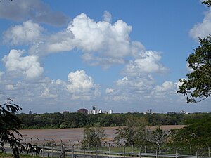
Santa Cruz de la Sierra
Largest city in Bolivia
Distance: Approx. 1852 meters
Latitude and longitude: -17.8,-63.18333333
Santa Cruz de la Sierra (Spanish: [ˈsanta ˈkɾus ðe la ˈsjera]; lit. 'Holy Cross of the Mountain Range'), commonly known as Santa Cruz, is the largest city in Bolivia and the capital of the Santa Cruz department. Situated on the Pirai River in the eastern Tropical Lowlands of Bolivia, the Santa Cruz de la Sierra Metropolitan Region is the most populous urban agglomeration in Bolivia with an estimated population of 2.4 million in 2020. It is formed out of a conurbation of seven Santa Cruz municipalities: Santa Cruz de la Sierra, La Guardia, Warnes, Cotoca, El Torno, Porongo, and Montero.
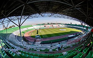
Estadio Ramón Tahuichi Aguilera
Stadium in Santa Cruz, Bolivia
Distance: Approx. 1421 meters
Latitude and longitude: -17.796067,-63.183873
Estadio Ramón "Tahuichi" Aguilera Costas is a multi-purpose stadium in Santa Cruz, Bolivia. It is used mostly for football matches, on club level by Blooming, Oriente Petrolero, Destroyers, and Royal Pari. Inaugurated in 1940, the stadium has a capacity of 38,000 people and was one of the official stadiums for the 1997 Copa America.

Roman Catholic Archdiocese of Santa Cruz de la Sierra
Catholic ecclesiastical territory
Distance: Approx. 89 meters
Latitude and longitude: -17.7841,-63.1818
The Roman Catholic Archdiocese of Santa Cruz de la Sierra (Latin: Archidioecesis Sanctae Crucis de Sierra) is an ecclesiastical territory or diocese of the Roman Catholic Church in Bolivia. It was erected as the Diocese of Santa Cruz de la Sierra by Pope Paul V on July 5, 1605, and was elevated to the rank of a metropolitan archdiocese by Pope Paul VI on July 30, 1975, with the suffragan see of San Ignacio de Velasco. The seat of its archbishop is Cathedral-Basilica of San Lorenzo.

El Trompillo Airport
Airport serving Santa Cruz de la Sierra, Bolivia
Distance: Approx. 3320 meters
Latitude and longitude: -17.81138889,-63.17138889
El Trompillo Airport (IATA: SRZ, ICAO: SLET) is located in the south part of Santa Cruz, Bolivia, about 2 km (1.25 miles) away from the central plaza.
Andrés Ibáñez Province
Province in Santa Cruz Department, Bolivia
Distance: Approx. 9085 meters
Latitude and longitude: -17.83333333,-63.25
Andrés Ibáñez Province is one of the fifteen provinces of the Bolivian Santa Cruz Department, situated in the western part of the department. Its capital is Santa Cruz de la Sierra which is also the capital of the department. The province was created on December 6, 1944, during the presidency of Gualberto Villarroel López.
Avenida Monseñor Rivero
Distance: Approx. 1150 meters
Latitude and longitude: -17.773075,-63.18236111
Avenida Monseñor Rivero is a street in Santa Cruz de la Sierra, Bolivia. It is located between the 1st and 2nd ring roads of the city, and is full of restaurants, cafes and bars catering to the wealthier sectors. At one end of the street stands the Cristo Redentor statue, which is used as an iconic image of cruceño identity.
Pampa de la Isla
Distance: Approx. 7806 meters
Latitude and longitude: -17.76077778,-63.1125
Pampa de la Isla is a township in Santa Cruz de la Sierra, Bolivia. The township is one of the key settlements of migrants from other parts of Bolivia. The settlement was founded on August 14, 1960, with less than thirty families.
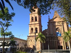
Cathedral Basilica of St. Lawrence, Santa Cruz de la Sierra
Church in Santa Cruz de la Sierra, Bolivia
Distance: Approx. 104 meters
Latitude and longitude: -17.7842,-63.1817
The Cathedral Basilica of St. Lawrence (Spanish: Catedral Metropolitana Basílica de San Lorenzo), also called Santa Cruz de la Sierra Cathedral, is the main Catholic church in the city of Santa Cruz de la Sierra, Bolivia. It is located in the city center, opposite the 24 de Septiembre Square.
Private University of Santa Cruz de la Sierra
Distance: Approx. 4317 meters
Latitude and longitude: -17.7625,-63.1479
Private University of Santa Cruz de la Sierra (Universidad Privada de Santa Cruz de la Sierra) is a private University in Bolivia. Alumni include Brenda Boral, Luis Fernando Camacho and Liliana Colanzi. Faculty includes Raquel Couzet.

General Cemetery of Santa Cruz
Distance: Approx. 1254 meters
Latitude and longitude: -17.78138889,-63.17055556
The General Cemetery of Santa Cruz (Cementerio General de Santa Cruz) is a public cemetery located in Santa Cruz de la Sierra, Bolivia. Located on Viedma Avenue and surrounded by Arenales, Paitití and Salvatierra Streets, it is one of the municipal administration cemeteries.
Weather in this IP's area
smoke
31 Celsius
35 Celsius
31 Celsius
31 Celsius
1010 hPa
62 %
1010 hPa
964 hPa
1800 meters
6.69 m/s
340 degree
05:50:11
18:10:57