Country:
Region:
City:
Latitude and Longitude:
Time Zone:
Postal Code:
IP information under different IP Channel
ip-api
Country
Region
City
ASN
Time Zone
ISP
Blacklist
Proxy
Latitude
Longitude
Postal
Route
Luminati
Country
Region
lim
City
limaregion
ASN
Time Zone
America/Lima
ISP
MEDIA COMMERCE PERU S.A.C
Latitude
Longitude
Postal
IPinfo
Country
Region
City
ASN
Time Zone
ISP
Blacklist
Proxy
Latitude
Longitude
Postal
Route
db-ip
Country
Region
City
ASN
Time Zone
ISP
Blacklist
Proxy
Latitude
Longitude
Postal
Route
ipdata
Country
Region
City
ASN
Time Zone
ISP
Blacklist
Proxy
Latitude
Longitude
Postal
Route
Popular places and events near this IP address
International Potato Center
Tuber research institute in Peru
Distance: Approx. 2688 meters
Latitude and longitude: -12.07694444,-76.94611111
The International Potato Center (known as CIP from its Spanish-language name Centro Internacional de la Papa) is a research facility based in Lima, Peru, that seeks to reduce poverty and achieve food security on a sustained basis in developing countries through scientific research and related activities on potato, sweet potato, other root and tuber crops, and on the improved management of natural resources in the Andes and other mountain areas.

National Agrarian University
Public university in Lima, Peru
Distance: Approx. 3279 meters
Latitude and longitude: -12.082,-76.948
The National Agrarian University, also formally called National Agrarian University – La Molina (Spanish: Universidad Nacional Agraria La Molina) (UNALM), is a public university in Lima, Peru. Of particular renown in the fields of agricultural, biological, and forestry sciences, it is also the only university in Peru offering degrees in meteorology. The university is organized into eight faculties which contain twelve academic departments.

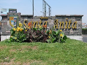
Santa Anita District
District in Lima, Peru
Distance: Approx. 2082 meters
Latitude and longitude: -12.04305556,-76.95833333
Santa Anita is a district of the Lima Province in Peru. It is part of city of Lima. Officially established as a district on October 25, 1989, from parts of Ate and El Agustino separated by the Rio Surco, a ditch which went all the way to Santiago de Surco.

Lima Peru Temple
Distance: Approx. 1988 meters
Latitude and longitude: -12.069713,-76.948897
The Lima Peru Temple is the 38th operating temple of the Church of Jesus Christ of Latter-day Saints (LDS Church).
University of San Martín de Porres
Private nonprofit university in Lima, Peru
Distance: Approx. 3146 meters
Latitude and longitude: -12.0454,-76.97
The University of San Martin de Porres (USMP) is a private nonprofit university located in the city of Lima, Peru. It was founded by the Dominican Order of the Catholic Church in 1962.

Universidad San Ignacio de Loyola
Private institution for higher education and research in Lima, Peru
Distance: Approx. 2396 meters
Latitude and longitude: -12.072536,-76.951656
St. Ignatius of Loyola University (Spanish: Universidad San Ignacio de Loyola) (USIL) is a private institution for higher education and research in Lima, Peru. It was founded in 1995, as part of the Educational Corporation San Ignacio de Loyola, by Raúl Diez Canseco.

Puruchuco
Archaeological site in Peru
Distance: Approx. 770 meters
Latitude and longitude: -12.0496,-76.9361
Puruchuco is an archaeological site in Peru that was an administrative center of the Inca period (1438–1533), located in the Ate District, in Lima.
Women's University of the Sacred Heart
University in Lima, Peru
Distance: Approx. 3300 meters
Latitude and longitude: -12.0717,-76.9658
The Women's University of the Sacred Heart (UNIFÉ) is a private university for women, located in the city of Lima, Peru. It was founded and sponsored by the Congregation of Sisters of the Sacred Heart of Jesus of the Catholic Church on December 24, 1962. Its headquarters are in the district of La Molina.
La Planicie
Neighbourhood in Lima, Peru
Distance: Approx. 4245 meters
Latitude and longitude: -12.075,-76.91027778
La Planicie is a neighbourhood in La Molina District, Lima, Peru. A gated community, it is inhabited by upper-class families and considered one of the most exclusive and expensive areas of the city.

La Atarjea Water Treatment Plant
Water treatment plant in Lima, Peru
Distance: Approx. 4034 meters
Latitude and longitude: -12.0387,-76.9762
La Atarjea is a water treatment plant located in El Agustino, a district of Lima, Peru. Originally a spring, it serves the headquarters of SEDAPAL, the city's water treatment company that also services Callao.

Colegio Sagrados Corazones Recoleta
School in Lima, Peru
Distance: Approx. 3183 meters
Latitude and longitude: -12.075,-76.961
The Colegio de los Sagrados Corazones Recoleta is a private Catholic school in La Molina District, Lima, Peru. Founded in 1893 by a French mission of the Congregation of the Sacred Hearts of Jesus and Mary as a all-boys school in central Lima, it is currently a mixed-sex school.
Barbadillo Prison
Prison in Lima, Peru
Distance: Approx. 3320 meters
Latitude and longitude: -12.04286111,-76.91355556
Barbadillo Prison is a prison facility located in Lima, Peru administered by the National Penitentiary Institute. Known as the "presidential prison" for being the place of detention of the former presidents, it has hosted former presidents Alberto Fujimori and Ollanta Humala. Currently imprisoned at the facility are former presidents Alejandro Toledo and Pedro Castillo.
Weather in this IP's area
clear sky
17 Celsius
17 Celsius
16 Celsius
17 Celsius
1014 hPa
79 %
1014 hPa
980 hPa
10000 meters
3.09 m/s
170 degree
05:32:58
18:10:38