Country:
 Chile
ChileRegion:
City:
Latitude and Longitude:
Time Zone:
Postal Code:
IP information under different IP Channel
ip-api
Country
Region
City
ASN
Time Zone
ISP
Blacklist
Proxy
Latitude
Longitude
Postal
Route
IPinfo
Country
Region
City
ASN
Time Zone
ISP
Blacklist
Proxy
Latitude
Longitude
Postal
Route
MaxMind
Country
Region
City
ASN
Time Zone
ISP
Blacklist
Proxy
Latitude
Longitude
Postal
Route
Luminati
Country
CLRegion
ap
City
arica
ASN
Time Zone
America/Santiago
ISP
Telmex Servicios Empresariales S.A.
Latitude
Longitude
Postal
db-ip
Country
Region
City
ASN
Time Zone
ISP
Blacklist
Proxy
Latitude
Longitude
Postal
Route
ipdata
Country
Region
City
ASN
Time Zone
ISP
Blacklist
Proxy
Latitude
Longitude
Postal
Route
Popular places and events near this IP address
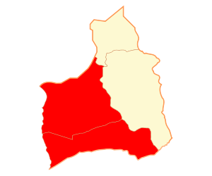
Arica Province
Province in Arica y Parinacota, Chile
Distance: Approx. 1307 meters
Latitude and longitude: -18.475,-70.31444444
Arica Province (Spanish: Provincia de Arica) is one of two provinces of Chile's northernmost region, Arica y Parinacota. The province is bordered on the north by the Tacna Province of Peru, on the south by the Tamarugal Province in the Tarapacá Region, on the east the Parinacota Province and on the west by the Pacific Ocean. Its capital is the port city of Arica.

Arica
City in Arica y Parinacota, Chile
Distance: Approx. 1956 meters
Latitude and longitude: -18.47838889,-70.32122222
Arica ( ə-REE-kə; Spanish: [aˈɾika]) is a commune and a port city with a population of 222,619 in the Arica Province of northern Chile's Arica y Parinacota Region. It is Chile's northernmost city, being located only 18 km (11 mi) south of the border with Peru. The city is the capital of both the Arica Province and the Arica and Parinacota Region.

Morro de Arica
Historically significant hill in Arica at the coast of northernmost Chile
Distance: Approx. 2215 meters
Latitude and longitude: -18.48027778,-70.32361111
Morro de Arica is a steep hill located in the Chilean city of Arica. Its height is 139 metres above sea level. It was the last bulwark of defense for the Peruvian troops who garrisoned the city during the War of the Pacific (1879–1883).
University of Tarapacá
Distance: Approx. 1247 meters
Latitude and longitude: -18.47111111,-70.31138889
University of Tarapacá (Spanish: Universidad de Tarapacá) is a university in Arica, Chile. It is a derivative university part of the Chilean Traditional Universities. The university publishes Revista Chungará a journal on anthropology and archaeology.

Arica y Parinacota Region
Region of Chile
Distance: Approx. 1307 meters
Latitude and longitude: -18.475,-70.31444444
The Arica y Parinacota Region (Spanish: Región de Arica y Parinacota pronounced [aˈɾikaj paɾinaˈkota]) is one of Chile's 16 first order administrative divisions. It comprises two provinces, Arica and Parinacota. It borders Peru's Department of Tacna to the north, Bolivia's La Paz and Oruro departments to the east and Chile's Tarapacá Region to the south.

Estadio Carlos Dittborn
Multi-purpose stadium in Arica, Chile
Distance: Approx. 1048 meters
Latitude and longitude: -18.4875,-70.29916667
The Carlos Dittborn Stadium (Spanish: Estadio Carlos Dittborn) is a multi-purpose stadium in Arica, Chile. Primarily used for football matches, it was constructed in 1962 specifically for the purpose of hosting games during the 1962 World Cup, which took place in Chile. The stadium, named after Carlos Dittborn, the president of the Chilean Organization Committee for the World Cup, who died a month before the tournament began, currently has a seating capacity of 9,746 spectators.

St. Mark's Cathedral, Arica
Church in Arica, Chile
Distance: Approx. 1901 meters
Latitude and longitude: -18.479,-70.3207
The St. Mark's Cathedral (Spanish: Catedral de San Marcos) also called Arica Cathedral is a Catholic church that is located in the city of Arica in the far north of Chile. The building was a commission by the government of the Peruvian President José Balta to the workshops of the Frenchman Gustave Eiffel and originally intended for the Ancón resort.
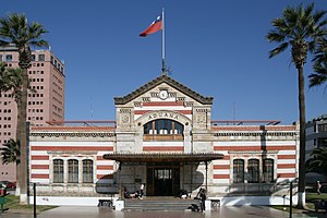
Arica House of Culture
National monument of Chile
Distance: Approx. 1950 meters
Latitude and longitude: -18.47714,-70.3211
The Arica House of Culture (Spanish: Casa de la Cultura de Arica), also known as Former Arica Custom House, is a building located in Arica, Chile. Designed by Gustave Eiffel's company, it was built between 1871 and 1874, prior to the annexation of Arica by Chile. The building was declared a National Monument of Chile on November 23, 1977, within the category of Historic Monuments.

Arica Department
Distance: Approx. 839 meters
Latitude and longitude: -18.47166667,-70.30555556
The Arica Department was a territorial division of Chile that existed between 1884 and 1929. It was ceded by the Treaty of Ancón in 1883 and placed under military administration, and then created on the 31st of October 1884, as one of the three departments of the Tacna Province, and was returned to Peru at midnight on the 28th of August 1929, under the terms agreed upon in the Treaty of Lima of the same year.
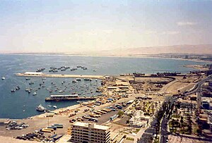
Port of Arica
Port in Chile
Distance: Approx. 2337 meters
Latitude and longitude: -18.473,-70.324
The Port of Arica (Spanish: Puerto de Arica, Terminal Portuario de Arica; TPA) is the main port of the northernmost coastal Chilean city of Arica. The northern part of the port, known by its acronym, MASP Arica (Spanish: Muelle al servicio del Perú en Arica), is operated by the Peruvian State. It is one of the six most active ports in Chile, alongside those of Iquique, Lirquén, San Antonio, San Vicente and Valparaíso.

Casa Yanulaque
Historical building and consulate in Chile
Distance: Approx. 1414 meters
Latitude and longitude: -18.47996,-70.31603
The Casa Yanulaque is a historical building located in the Chilean city of Arica, in the corner of 18 de Septiembre and General Lagos streets. It is owned by the Peruvian State as part of the 1929 Treaty of Lima, and currently houses its consulate-general. It is named after the Yanulaque Ayala family (Greek: Γιαννουλάκης, romanized: Giannoulakis), a Greek family currently well known in the city that once promoted a plebiscite during the Chilean–Peruvian territorial dispute.

Casa Bolognesi
Historical building in Chile
Distance: Approx. 1928 meters
Latitude and longitude: -18.4801,-70.3209
The Casa Bolognesi, also known as the Casa de la Respuesta (House of the Reply), is a historical building owned by the Peruvian State located in Arica, Chile. It is the site of a meeting that preceded the Battle of Arica during the War of the Pacific.
Weather in this IP's area
overcast clouds
18 Celsius
18 Celsius
18 Celsius
21 Celsius
1013 hPa
63 %
1013 hPa
1008 hPa
10000 meters
3.09 m/s
250 degree
100 %
07:32:09
19:36:53