179.1.82.16 - IP Lookup: Free IP Address Lookup, Postal Code Lookup, IP Location Lookup, IP ASN, Public IP
Country:
Region:
City:
Location:
Time Zone:
Postal Code:
IP information under different IP Channel
ip-api
Country
Region
City
ASN
Time Zone
ISP
Blacklist
Proxy
Latitude
Longitude
Postal
Route
Luminati
Country
Region
cun
ASN
Time Zone
America/Bogota
ISP
SAMM TECNOLOGIA E TELECOMUNICACOES S.A
Latitude
Longitude
Postal
IPinfo
Country
Region
City
ASN
Time Zone
ISP
Blacklist
Proxy
Latitude
Longitude
Postal
Route
IP2Location
179.1.82.16Country
Region
narino
City
pasto
Time Zone
America/Bogota
ISP
Language
User-Agent
Latitude
Longitude
Postal
db-ip
Country
Region
City
ASN
Time Zone
ISP
Blacklist
Proxy
Latitude
Longitude
Postal
Route
ipdata
Country
Region
City
ASN
Time Zone
ISP
Blacklist
Proxy
Latitude
Longitude
Postal
Route
Popular places and events near this IP address

Nariño Department
Department of Colombia
Distance: Approx. 5476 meters
Latitude and longitude: 1.16666667,-77.26666667
Nariño (Spanish pronunciation: [naˈɾiɲo]) is a department of Colombia named after independence leader Antonio Nariño. Its capital is Pasto. It is in the west of the country, bordering Ecuador and the Pacific Ocean.

Pasto, Colombia
Municipality and city in Pacific Region/Andes Region, Colombia
Distance: Approx. 798 meters
Latitude and longitude: 1.20777778,-77.27722222
Pasto, officially San Juan de Pasto (Spanish pronunciation: [saŋ ˈxwan de ˈpasto]; "Saint John of Pasto"), is the capital of the department of Nariño, in southern Colombia. Pasto was founded in 1537 and named after indigenous people of the area. In the 2018 census, the municipality had a population of 392,930.

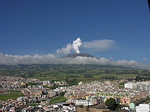
Galeras
Volcanic mountain in Colombia
Distance: Approx. 8695 meters
Latitude and longitude: 1.22111111,-77.35916667
Galeras (Urcunina among the 16th-century indigenous people) is an Andean stratovolcano in the Colombian department of Nariño, near the departmental capital Pasto. Its summit rises 4,276 metres (14,029 ft) above sea level. It has erupted frequently since the Spanish conquest, with its first historical eruption being recorded on December 7, 1580.
Deportivo Pasto
Colombian soccer club
Distance: Approx. 1784 meters
Latitude and longitude: 1.19805556,-77.2775
Asociación Deportivo Pasto, also known as Deportivo Pasto, is a Colombian professional football team based in the city of Pasto, that currently plays in the Categoría Primera A. They play their home games at the Estadio Departamental Libertad. Deportivo Pasto is both the southernmost and westernmost based team in the Colombian league. Founded in 1949, Pasto has won the league title once in the 2006 Apertura and finished as runner-up three times: in the 2002 Finalizacion, 2012 Apertura, and 2019 Apertura.

Estadio Departamental Libertad
Stadium in Pasto, Colombia
Distance: Approx. 1786 meters
Latitude and longitude: 1.19801111,-77.27760833
Estadio Departamental Libertad is a multi-purpose stadium in Pasto, Colombia. It is used mostly for football matches and is the home stadium of Deportivo Pasto. The stadium holds 18,000 people and was built in 1955.
University of Nariño
Distance: Approx. 2330 meters
Latitude and longitude: 1.23416667,-77.28527778
The University of Nariño (Spanish: Universidad de Nariño), also called Udenar, is a public, coeducational, research university based primarily in the city of Pasto, Nariño, Colombia. It is the largest higher education institution by student population in the department with 9,867 students. Its origins can be traced to 1712, but it was officially established by governor Julian Buchelli through decree 049 of November 7, 1904.
St. Francis Xavier College, Pasto
School in San Juan de Pasto, Nariño, Colombia
Distance: Approx. 559 meters
Latitude and longitude: 1.21527778,-77.27666667
St. Francis Xavier College (Spanish: Colegio San Francisco Javier), is a private Catholic pre-school, primary, and a secondary school, located in San Juan de Pasto, Nariño, Colombia. The school was founded by the Society of Jesus in 1925.
Weather in this IP's area
broken clouds
11 Celsius
11 Celsius
11 Celsius
11 Celsius
1018 hPa
95 %
1018 hPa
756 hPa
10000 meters
1.75 m/s
1.59 m/s
148 degree
76 %