179.1.76.189 - IP Lookup: Free IP Address Lookup, Postal Code Lookup, IP Location Lookup, IP ASN, Public IP
Country:
Region:
City:
Location:
Time Zone:
Postal Code:
IP information under different IP Channel
ip-api
Country
Region
City
ASN
Time Zone
ISP
Blacklist
Proxy
Latitude
Longitude
Postal
Route
Luminati
Country
Region
cun
ASN
Time Zone
America/Bogota
ISP
SAMM TECNOLOGIA E TELECOMUNICACOES S.A
Latitude
Longitude
Postal
IPinfo
Country
Region
City
ASN
Time Zone
ISP
Blacklist
Proxy
Latitude
Longitude
Postal
Route
IP2Location
179.1.76.189Country
Region
narino
City
ipiales
Time Zone
America/Bogota
ISP
Language
User-Agent
Latitude
Longitude
Postal
db-ip
Country
Region
City
ASN
Time Zone
ISP
Blacklist
Proxy
Latitude
Longitude
Postal
Route
ipdata
Country
Region
City
ASN
Time Zone
ISP
Blacklist
Proxy
Latitude
Longitude
Postal
Route
Popular places and events near this IP address

Tulcán
City in Carchi, Ecuador
Distance: Approx. 7954 meters
Latitude and longitude: 0.81166667,-77.71861111
"Tulcan" is also an alternative spelling of tulchan Tulcán (Spanish pronunciation: [tulˈkan]) is the capital of the province of Carchi in Ecuador and the seat of Tulcán Canton. The population of the city of Tulcán was 56,719 in the 2022 census. Tulcán is known for its hot springs, deep wells, 3-acre topiary garden cemetery, the most elaborate topiary in the New World, created with Cupressus sempervirens by José Maria Azael Franco in 1936.

Ipiales
City in Colombia
Distance: Approx. 574 meters
Latitude and longitude: 0.83027778,-77.64444444
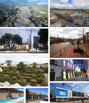
Ipiales is a city and Catholic bishopric in Nariño Department, southern Colombia, near the border with Ecuador. It is located at around 0°49′49″N 77°38′40″W, with an elevation of about 2950 m. Ipiales is located on the high plateau called "Tuquerres e Ipiales," the city lies at a distance of 82 km from Pasto, the department's capital." Ipiales is known as "la ciudad de las nubes verdes" (the city of the green clouds) because sometimes, especially in the afternoon, greenish clouds appear over the city.
Sanctuary of Las Lajas
Basilica church in Nariño, Colombia
Distance: Approx. 7594 meters
Latitude and longitude: 0.8055,-77.586
The Sanctuary of Las Lajas (in full Sanctuary of Our Lady of the Holy Rosary of Las Lajas) is a Catholic minor basilica located within the canyon of the Guáitara River in Ipiales, Nariño Department, Colombia. The Marian shrine is dedicated to the Blessed Virgin Mary as Our Lady of the Rosary. Pious believers claim that the colorful Madonna and Child image displayed on the rock wall is of divine origin, and that it was formed without human intervention.

Aldana
Municipality and town in Nariño Department, Colombia
Distance: Approx. 8152 meters
Latitude and longitude: 0.88333333,-77.7
Aldana is a town and municipality in the Nariño Department, Colombia.

Cuaspud
Municipality and town in Nariño Department, Colombia
Distance: Approx. 9728 meters
Latitude and longitude: 0.865833,-77.7294
Cuaspud (Spanish pronunciation: [kwasˈpuð]) is a town and municipality in the Nariño Department, Colombia.

Potosí, Nariño
Municipality and town in Nariño Department, Colombia
Distance: Approx. 8899 meters
Latitude and longitude: 0.80805556,-77.57277778
Potosí is a town and municipality in the Nariño Department, Colombia.

Pupiales
Municipality and town in Nariño Department, Colombia
Distance: Approx. 4060 meters
Latitude and longitude: 0.86666667,-77.65
Pupiales is a town and municipality in the Nariño Department, Colombia.

Roman Catholic Diocese of Tulcán
Roman Catholic diocese in Ecuador
Distance: Approx. 7954 meters
Latitude and longitude: 0.81166667,-77.71861111
The Roman Catholic Diocese of Tulcán (Latin: Dioecesis Tulcanensis) is a diocese located in the city of Tulcán in the ecclesiastical province of Quito in Ecuador.

Roman Catholic Diocese of Ipiales
Latin Catholic ecclesiastical territory in Colombia
Distance: Approx. 1829 meters
Latitude and longitude: 0.8235,-77.6346
The Diocese of Ipiales (Latin: Ipialensis) is a Latin Church ecclesiastical territory or diocese of the Catholic Church in Southern Colombia. It is a suffragan diocese in the ecclesiastical province of the metropolitan Archdiocese of Popayán.
Carchi River
River in Ecuador, Colombia
Distance: Approx. 2377 meters
Latitude and longitude: 0.8153,-77.6649
The Carchi River is a river of Ecuador. It rises on the slopes of Chiles Volcano, elevation 4,698 metres (15,413 ft), on the border of Ecuador and Colombia. The river flows eastward across the high plateau of El Angel.

Rumichaca Bridge
Bridge
Distance: Approx. 2377 meters
Latitude and longitude: 0.8153,-77.6649
The Rumichaca Bridge (Quechua rumi stone, chaka bridge, "stone bridge") is the principal highway passage between Colombia and Ecuador. The bridge is located 3 kilometres (1.9 mi) from the city of Ipiales, Colombia and 7 kilometres (4.3 mi) from the city of Tulcán, Ecuador. The bridge is located in the Andes at an elevation of 2,763 metres (9,065 ft).
Weather in this IP's area
overcast clouds
10 Celsius
10 Celsius
10 Celsius
10 Celsius
1019 hPa
100 %
1019 hPa
724 hPa
10000 meters
1.03 m/s
100 %

