179.1.73.151 - IP Lookup: Free IP Address Lookup, Postal Code Lookup, IP Location Lookup, IP ASN, Public IP
Country:
Region:
City:
Location:
Time Zone:
Postal Code:
IP information under different IP Channel
ip-api
Country
Region
City
ASN
Time Zone
ISP
Blacklist
Proxy
Latitude
Longitude
Postal
Route
Luminati
Country
Region
cun
ASN
Time Zone
America/Bogota
ISP
SAMM TECNOLOGIA E TELECOMUNICACOES S.A
Latitude
Longitude
Postal
IPinfo
Country
Region
City
ASN
Time Zone
ISP
Blacklist
Proxy
Latitude
Longitude
Postal
Route
IP2Location
179.1.73.151Country
Region
cundinamarca
City
chia
Time Zone
America/Bogota
ISP
Language
User-Agent
Latitude
Longitude
Postal
db-ip
Country
Region
City
ASN
Time Zone
ISP
Blacklist
Proxy
Latitude
Longitude
Postal
Route
ipdata
Country
Region
City
ASN
Time Zone
ISP
Blacklist
Proxy
Latitude
Longitude
Postal
Route
Popular places and events near this IP address

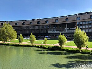
University of La Sabana
Distance: Approx. 2795 meters
Latitude and longitude: 4.86111111,-74.03361111
The Universidad de La Sabana is a private university in Colombia, supervised by the Colombian Ministry of Education. It was founded on September 21, 1979, by the Asociación para la Enseñanza Aspaen, its predecessor was the INSE "Instituto Superior de Educación", considered one of the first in distance education in the country and Latin America. La Sabana is one of the best universities in the country according to several rankings.

Chía, Cundinamarca
Municipality and city in Cundinamarca, Colombia
Distance: Approx. 1375 meters
Latitude and longitude: 4.85,-74.05
Chía is a city and municipality in the department of Cundinamarca in Colombia, located 10 km north of Bogotá on the main road to Zipaquira. Due to its proximity to Bogotá, Chía has effectively become a suburb of the capital. Its history dates back to the pre-Columbian era.
Escuela Colombiana de Ingeniería
Distance: Approx. 8681 meters
Latitude and longitude: 4.78222222,-74.04388889
The Escuela Colombiana de Ingeniería (Spanish for Colombian School of Engineering) Julio Garavito is a private engineering-based university. The school is located on a 70-acre (280,000 m2) campus in a beautiful natural environment in the north part of Bogotá and has approximately 4,600 students in undergraduate and graduate programs. It includes laboratories, computer systems, one of the largest collections of engineering texts and journals in Colombia as well as international and national access to information via the internet.
Cajicá
Municipality and town in Cundinamarca, Colombia
Distance: Approx. 7029 meters
Latitude and longitude: 4.91666667,-74.03333333
Cajicá is a municipality and town of Colombia in the department of Cundinamarca, 39 km (24 mi) north of the capital Bogotá. It is located in the Central Savanna Province, being the third most populous municipality in the province after Zipaquirá and Chía. It is bordered by the municipalities of Zipaquirá to the north, Sopó to the east, Chía to the south, and Tabio to the west.

Cota, Cundinamarca
Municipality and town in Cundinamarca, Colombia
Distance: Approx. 6556 meters
Latitude and longitude: 4.81666667,-74.1
Cota is a municipality and town of Colombia in the Central Savanna Province of the department of Cundinamarca. Cota is part of the metropolitan area of Colombian capital Bogotá which centre is 26 kilometres (16 mi) away. The urban centre of Cota is located at an altitude of 2,566 metres (8,419 ft) and the municipality borders Chía in the north, Funza in the south, Suba, part of Bogotá in the east and Tenjo in the west.

Tabio
Municipality and town in Cundinamarca, Colombia
Distance: Approx. 7722 meters
Latitude and longitude: 4.91583333,-74.09833333
Tabio is a municipality and town of Colombia in the department of Cundinamarca. It's located at 45 km (28 mi) from Bogotá. The town was officially founded April 8, 1603, by Diego Gómez de Mena, on grounds that were the property of the native Muisca who inhabited the area.

Guaymaral Airport
Airport
Distance: Approx. 5205 meters
Latitude and longitude: 4.8125,-74.06527778
Guaymaral Airport (ICAO: SKGY) is a high-elevation airport in the north of Bogotá, Colombia, also serving the towns of Cota and Chía. The runway is 15 kilometres (9.3 mi) northeast of Bogota's El Dorado International Airport.
Hipódromo de Los Andes
Distance: Approx. 2752 meters
Latitude and longitude: 4.8486,-74.0361
The Hipódromo De Los Andes is a horse racing track located in the north of Bogota, Colombia. It has a capacity for 20,000 people for concerts. Nowadays, it is used only for events.

Moon Temple (Chía)
Distance: Approx. 3406 meters
Latitude and longitude: 4.86993333,-74.08730556
The Moon Temple of Chía was a temple constructed by the Muisca as a place of worship for their Moon goddess Chía. The temple was built in Chía, Cundinamarca, Colombia, then part of the Muisca Confederation. It was one of the most important temples in the religion of the Muisca.
Guaymaral y Torca
Distance: Approx. 6309 meters
Latitude and longitude: 4.80491667,-74.04105556
Guaymaral y Torca (Spanish: Humedal Guaymaral y Torca) is a combined wetland, part of the Wetlands of Bogotá, located in the north of the Colombian capital in the localities Suba and Usaquén, Bogotá, Colombia. The wetlands on the Bogotá savanna cover an area of about 73 hectares (180 acres). Guaymaral y Torca, the northernmost wetlands of Bogotá at the foot of the Eastern Hills, is composed of three parts, Guaymaral in the west in Suba (49 hectares (120 acres)), Torca in the east in Usaquén (24 hectares (59 acres)) and a small strip along the dividing Autopista Norte between the two main wetlands.

Jardines de Paz
Distance: Approx. 9004 meters
Latitude and longitude: 4.78111111,-74.03611111
Jardines de Paz is a cemetery located north of Bogotá. The cemetery was established in 1970, and has an area of 610,000 square meters, on the eastern side of the Autopista Norte with Calle 200. It has a sector for the military, a chapel, crematoriums, a cafeteria, and administrative offices.
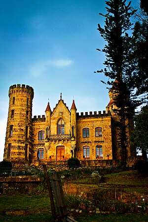
Castillo Marroquín
Palace in Chía, Cundinamarca, Colombia
Distance: Approx. 3661 meters
Latitude and longitude: 4.862575,-74.025908
Castillo Marroquín (Marroquín Castle) is a palace built in 1898, located on the grounds of the Hacienda El Castillo in the La Caro sector in Chía, Cundinamarca, Colombia. It owes its name to the fact that it is located on the land that was part of the estate of former president José Manuel Marroquín.
Weather in this IP's area
broken clouds
18 Celsius
17 Celsius
18 Celsius
19 Celsius
1012 hPa
52 %
1012 hPa
736 hPa
10000 meters
0.82 m/s
2.77 m/s
195 degree
54 %

