179.1.70.244 - IP Lookup: Free IP Address Lookup, Postal Code Lookup, IP Location Lookup, IP ASN, Public IP
Country:
Region:
City:
Location:
Time Zone:
Postal Code:
IP information under different IP Channel
ip-api
Country
Region
City
ASN
Time Zone
ISP
Blacklist
Proxy
Latitude
Longitude
Postal
Route
Luminati
Country
Region
cun
ASN
Time Zone
America/Bogota
ISP
SAMM TECNOLOGIA E TELECOMUNICACOES S.A
Latitude
Longitude
Postal
IPinfo
Country
Region
City
ASN
Time Zone
ISP
Blacklist
Proxy
Latitude
Longitude
Postal
Route
IP2Location
179.1.70.244Country
Region
arauca
City
arauca
Time Zone
America/Bogota
ISP
Language
User-Agent
Latitude
Longitude
Postal
db-ip
Country
Region
City
ASN
Time Zone
ISP
Blacklist
Proxy
Latitude
Longitude
Postal
Route
ipdata
Country
Region
City
ASN
Time Zone
ISP
Blacklist
Proxy
Latitude
Longitude
Postal
Route
Popular places and events near this IP address

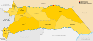
Arauca Department
Department of Colombia
Distance: Approx. 1017 meters
Latitude and longitude: 7.08333333,-70.75
Arauca (Spanish pronunciation: [aˈɾawka]) is a department of Eastern Colombia located in the extreme north of the Orinoco Basin of Colombia (the Llanos Orientales), bordering Venezuela. The southern boundary of Arauca is formed by the Casanare and Meta Rivers, separating Arauca from the departments of Casanare and Vichada. To the west, Arauca borders the department of Boyacá.
Arauca, Arauca
Municipality and city in Arauca Department, Colombia
Distance: Approx. 683 meters
Latitude and longitude: 7.09027778,-70.76166667
Arauca is a municipality and capital city of the Arauca Department of Colombia. Its full name is Villa de Santa Bárbara de Arauca, it is located at N 07° 05′ 25″ - W 70° 45′ 42″. The Municipality of Arauca has a total population of 85,585 (2018 census).

Roman Catholic Diocese of Arauca
Diocese of the Catholic Church in Colombia
Distance: Approx. 683 meters
Latitude and longitude: 7.09027778,-70.76166667
The Roman Catholic Diocese of Arauca (Latin: Araucensis) is a diocese located in the city of Arauca in the ecclesiastical province of Nueva Pamplona in Colombia.
El Amparo, Apure
Place in Apure, Venezuela
Distance: Approx. 1897 meters
Latitude and longitude: 7.1,-70.76666667
El Amparo is a town located in Páez Municipality, Apure of Venezuela. It is located on the border with Colombia, on the banks of the Arauca River. The Massacre of El Amparo took place near the town.
Weather in this IP's area
scattered clouds
32 Celsius
38 Celsius
32 Celsius
32 Celsius
1009 hPa
62 %
1009 hPa
994 hPa
10000 meters
1.54 m/s
70 degree
40 %
