Country:
Region:
City:
Latitude and Longitude:
Time Zone:
Postal Code:
IP information under different IP Channel
ip-api
Country
Region
City
ASN
Time Zone
ISP
Blacklist
Proxy
Latitude
Longitude
Postal
Route
Luminati
Country
Region
san
City
bucaramanga
ASN
Time Zone
America/Bogota
ISP
SAMM TECNOLOGIA E TELECOMUNICACOES S.A
Latitude
Longitude
Postal
IPinfo
Country
Region
City
ASN
Time Zone
ISP
Blacklist
Proxy
Latitude
Longitude
Postal
Route
db-ip
Country
Region
City
ASN
Time Zone
ISP
Blacklist
Proxy
Latitude
Longitude
Postal
Route
ipdata
Country
Region
City
ASN
Time Zone
ISP
Blacklist
Proxy
Latitude
Longitude
Postal
Route
Popular places and events near this IP address

Industrial University of Santander
Distance: Approx. 2041 meters
Latitude and longitude: 7.14069722,-73.12096667
The Industrial University of Santander (Spanish: Universidad Industrial de Santander), abbreviated in Spanish with the acronym UIS, is a public university, based in a coeducational, and research model. The university serves the Santander Department, being the main campus located in the city of Bucaramanga, Santander, Colombia. The university also has satellite campuses across the department in the cities of Barrancabermeja, Barbosa, Málaga, Piedecuesta, Socorro.

Estadio Américo Montanini
Distance: Approx. 1362 meters
Latitude and longitude: 7.13333333,-73.11666667
Estadio Américo Montanini (formerly Alfonso López) is a sports venue located in the Colombian city of Bucaramanga. It has a capacity for 25,000 spectators. It is the headquarters of Atlético Bucaramanga, club of the Categoría Primera A of the Dimayor.
Colegio San Pedro Claver
Private Catholic school in Santander, Colombia
Distance: Approx. 1120 meters
Latitude and longitude: 7.11754722,-73.11331944
Colegio San Pedro Claver is a private Catholic primary and secondary school, located in Bucaramanga, in the Santander Department of Colombia. The school was founded by the Society of Jesus in 1897 and is named in honour of St Peter Claver, the patron saint of Colombia. Students and graduates of the school are known as Claverians.

Atlético Bucaramanga
Association football club
Distance: Approx. 1702 meters
Latitude and longitude: 7.13666667,-73.11666667
Club Atlético Bucaramanga S.A., better known as Atlético Bucaramanga, is a Colombian professional football team based in Bucaramanga. The club plays its home games at the Américo Montanini stadium. The club was founded on 11 May 1949 by Rafael Chaberman, a Barranquilla businessman.
San Juan de Girón
Municipality in Santander Department, Colombia
Distance: Approx. 8032 meters
Latitude and longitude: 7.07083333,-73.17305556
San Juan de Girón (better known as Girón), formerly: Villa de los Caballeros de Girón, is a municipality of the Santander Department, which is part of the Bucaramanga Metropolitan area in northeastern Colombia.
Rionegro, Santander
Municipality and town in Santander, Colombia
Distance: Approx. 4909 meters
Latitude and longitude: 7.15361,-73.1536
Rionegro (Spanish pronunciation: [rioˈneɣɾo]) is a town and municipality in the department of Santander in northeastern Colombia. The urban centre of Rionegro is located at an altitude of 590 metres (1,940 ft) in the Eastern Ranges of the Colombian Andes, 20 kilometres (12 mi) north of the departmental capital Bucaramanga. The municipality is named after the Río Negro.

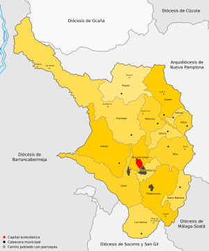
Roman Catholic Archdiocese of Bucaramanga
Catholic archdiocese in Colombia
Distance: Approx. 878 meters
Latitude and longitude: 7.1167,-73.1167
The Roman Catholic Archdiocese of Bucaramanga (Latin: Bucaramanguensis) is an archdiocese located in the city of Bucaramanga in Colombia.

University of Santander
Colombian private research university
Distance: Approx. 3526 meters
Latitude and longitude: 7.1055,-73.0952
The University of Santander (UDES) is a private research university, approved by the Colombian government through the Ministry of Education, according to legal status 810 1996; organized under the provisions of Act 30 of 1992. This university has different locations in Colombia and Latin America being the main campus located in Bucaramanga, other campus are Panama City (Panama), Bogotá, Cúcuta and Valledupar. Provides technical, undergraduate, graduate, postgraduate, and continual education programs.

Coliseo Bicentenario
Indoor arena in Bucaramanga, Colombia
Distance: Approx. 1876 meters
Latitude and longitude: 7.1382,-73.1163
Coliseo Bicentenario Alejandro Galvis Ramírez, mostly known as Coliseo Bicentenario, is an indoor sporting arena, located in Bucaramanga, Colombia. The stadium was built in 2011 for the AMF Futsal Men's World Cup and is part of the Villa Olímpica Alfonso López (Alfonso López Olympic Village), which is also composed by the Alfonso López stadium. The capacity of the stadium is for 7,000 spectators.
Bucaramanga–Santa Marta Fault
Colombian fault system
Distance: Approx. 5242 meters
Latitude and longitude: 7.09027778,-73.0875
The Bucaramanga–Santa Marta Fault (BSMF, BSF) or Bucaramanga–Santa Marta fault system (Spanish: (Sistema de) Falla(s) de Bucaramanga-Santa Marta) is a major oblique transpressional sinistral strike-slip fault (wrench fault) in the departments of Magdalena, Cesar, Norte de Santander and Santander in northern Colombia. The fault system is composed of two main outcropping segments, the Santa Marta and Bucaramanga faults, and an intermediate Algarrobo Fault segment in the subsurface. The system has a total length of 674 kilometres (419 mi) and runs along an average north-northwest to south-southeast strike of 341 ± 23 from the Caribbean coast west of Santa Marta to the northern area of the Eastern Ranges of the Colombian Andes.
Weather in this IP's area
scattered clouds
25 Celsius
25 Celsius
25 Celsius
25 Celsius
1012 hPa
78 %
1012 hPa
905 hPa
10000 meters
3.09 m/s
180 degree
40 %
05:40:22
17:31:41


