178.92.2.191 - IP Lookup: Free IP Address Lookup, Postal Code Lookup, IP Location Lookup, IP ASN, Public IP
Country:
 Ukraine
Region:
City:
Location:
Time Zone:
Postal Code:
ISP:
ASN:
language:
User-Agent:
Proxy IP:
Blacklist:
IP information under different IP Channel
ip-api
Country
Region
City
ASN
Time Zone
ISP
Blacklist
Proxy
Latitude
Longitude
Postal
Route
db-ip
Country
Region
City
ASN
Time Zone
ISP
Blacklist
Proxy
Latitude
Longitude
Postal
Route
IPinfo
Country
Region
City
ASN
Time Zone
ISP
Blacklist
Proxy
Latitude
Longitude
Postal
Route
IP2Location
178.92.2.191Country
uaRegion
kirovohradska oblast
City
kropyvnytskyi
Time Zone
ISP
Language
User-Agent
Latitude
Longitude
Postal
ipdata
Country
Region
City
ASN
Time Zone
ISP
Blacklist
Proxy
Latitude
Longitude
Postal
Route
Popular places and events near this IP address
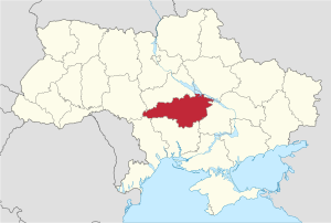
Kirovohrad Oblast
Oblast (region) of Ukraine
Distance: Approx. 5971 meters
Latitude and longitude: 48.46,32.27
Kirovohrad Oblast (Ukrainian: Кіровоградська область, romanized: Kirovohradska oblast), also known as Kirovohradshchyna (Ukrainian: Кіровоградщина), is an oblast (province) in central Ukraine. The administrative center of the oblast is the city of Kropyvnytskyi. Its population is 903,712 (2022 estimate).

Kropyvnytskyi
City in Kirovohrad Oblast, Ukraine
Distance: Approx. 1557 meters
Latitude and longitude: 48.5,32.26666667
Kropyvnytskyi (Ukrainian: Кропивницький, IPA: [kropɪu̯ˈnɪtsʲkɪj] ) is a city in central Ukraine, situated on the Inhul River. It serves as the administrative center of Kirovohrad Oblast. Population: 219,676 (2022 estimate).

Zirka Stadium
Distance: Approx. 591 meters
Latitude and longitude: 48.51583333,32.26666667
Zirka Stadium is a multifunctional facility, primarily used for football located in Kropyvnytskyi, Ukraine. The stadium is the biggest one in Kirovohrad Oblast. Currently the professional football club FC Zirka Kropyvnytskyi plays their home games at the stadium.

Kropyvnytskyi Airport
Airport in Kirovohrad Oblast, Ukraine
Distance: Approx. 3788 meters
Latitude and longitude: 48.5425,32.28583333
Kropyvnytskyi Airport (Ukrainian: Аеропорт «Кропивницький») (IATA: KGO, ICAO: UKKG) is an airport in Kropyvnytskyi, Ukraine. It also serves State Flight Academy of Ukraine The airport is capable of handling An-2, An-24, An-26, An-28, An-30, An-32, An-72, An-74, An-140, L-410, Saab 340, Yak-40 aircraft. Just one of the two runways is currently operational (the 1300m one).
Kropyvnytskyi urban hromada
Urban hromada of Kropyvnytskyi Oblast, Ukraine
Distance: Approx. 1557 meters
Latitude and longitude: 48.5,32.26666667
Kropyvnytskyi urban territorial hromada (Ukrainian: Кропивницька міська територіальна громада, romanized: Kropyvnytska miska terytorialna hromada) is a hromada in Kropyvnytskyi Raion, Kirovohrad Oblast, Ukraine. Its administrative centre is the city of Kropyvnytskyi. The hromada has an area of 105.0 km2 (40.5 sq mi), as well as a population of 9,704 (as of 2023).
Weather in this IP's area
clear sky
-5 Celsius
-10 Celsius
-5 Celsius
-5 Celsius
1038 hPa
77 %
1038 hPa
1017 hPa
10000 meters
3.27 m/s
8 m/s
43 degree
5 %