178.78.113.2 - IP Lookup: Free IP Address Lookup, Postal Code Lookup, IP Location Lookup, IP ASN, Public IP
Country:
Region:
City:
Location:
Time Zone:
Postal Code:
ISP:
ASN:
language:
User-Agent:
Proxy IP:
Blacklist:
IP information under different IP Channel
ip-api
Country
Region
City
ASN
Time Zone
ISP
Blacklist
Proxy
Latitude
Longitude
Postal
Route
db-ip
Country
Region
City
ASN
Time Zone
ISP
Blacklist
Proxy
Latitude
Longitude
Postal
Route
IPinfo
Country
Region
City
ASN
Time Zone
ISP
Blacklist
Proxy
Latitude
Longitude
Postal
Route
IP2Location
178.78.113.2Country
Region
england
City
salisbury
Time Zone
Europe/London
ISP
Language
User-Agent
Latitude
Longitude
Postal
ipdata
Country
Region
City
ASN
Time Zone
ISP
Blacklist
Proxy
Latitude
Longitude
Postal
Route
Popular places and events near this IP address

Salisbury
Cathedral city in Wiltshire, England
Distance: Approx. 68 meters
Latitude and longitude: 51.06972222,-1.795
Salisbury ( SAWLZ-bər-ee, locally SAWZ-bər-ee) is a cathedral city and civil parish in Wiltshire, England with a population of 41,820, at the confluence of the rivers Avon, Nadder and Bourne. The city is approximately 20 miles (30 kilometres) from Southampton and 30 miles (50 kilometres) from Bath. Salisbury is in the southeast of Wiltshire, near the edge of Salisbury Plain.
Salisbury Black Friary
Distance: Approx. 253 meters
Latitude and longitude: 51.0695,-1.7993
Salisbury Black Friary was a friary in Wiltshire, England, in existence from 1281 to 1538. In 1281, Edward I granted land to the Dominican friars which allowed them to move from the house they had established at Wilton in 1245. The site was at grid reference SU 1416 3004 on the north-west edge of the city, on what is now Fisherton Street, just beyond the bridge over the Avon.

Poultry Cross (Salisbury)
Grade I listed market cross in Salisbury, United Kingdom
Distance: Approx. 68 meters
Latitude and longitude: 51.06876,-1.79616
The Poultry Cross is a market cross in Salisbury, Wiltshire, England, marking the site of former markets. Constructed in the 14th century and modified in the 18th century, it stands at the junction of Silver Street and Minster Street. It has been designated by English Heritage as a Grade I listed structure.

The Bell and Crown, Salisbury
Distance: Approx. 295 meters
Latitude and longitude: 51.067,-1.7936
The Bell and Crown Inn, until April 2019 called The Cloisters, is a Grade II* listed public house in Catherine Street, Salisbury, Wiltshire, England. It dates from the fourteenth century.

Frowds Almshouses
Distance: Approx. 297 meters
Latitude and longitude: 51.0715,-1.7933
Frowds Almshouses are Grade II* listed almshouses at 1–12 Bedwin Street in Salisbury, Wiltshire, England. An inscribed stone above the original entrance reads: "Built and Endow'd by the Liberality of Mr EDWARD FROWD Merch[an]t late of this City. 1750." The building was constructed under the terms of the will of wealthy merchant Edward Frowd (d.
Salisbury bus station
Bus station in Salisbury, Wiltshire, England
Distance: Approx. 142 meters
Latitude and longitude: 51.07,-1.794
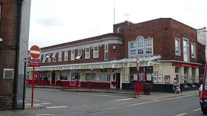
Salisbury bus station was a bus station in the city of Salisbury, Wiltshire, England. The station had five stands underneath a red brick building which was built in 1939 as the headquarters of the Wilts & Dorset bus company. It was closed in 2014 on the grounds of high maintenance costs.

Salisbury Guildhall
Municipal building in Salisbury, Wiltshire, England
Distance: Approx. 90 meters
Latitude and longitude: 51.069,-1.7945
Salisbury Guildhall is an 18th-century municipal building in the Market Place, Salisbury, England. The building, which is the meeting place of the Salisbury City Council, is a Grade II* listed building.

Salisbury power station
Distance: Approx. 146 meters
Latitude and longitude: 51.06916667,-1.79777778
Salisbury power station supplied electricity to the English city of Salisbury and the surrounding area from 1898 to c. 1970. It was owned and operated by Salisbury Electric Light and Supply Company Limited prior to the nationalisation of the British electricity supply industry in 1948.

John Halle's Hall
Grade I listed late medieval building in Salisbury, United Kingdom
Distance: Approx. 116 meters
Latitude and longitude: 51.06841,-1.79484
John Halle's Hall is a 15th-century late medieval building, a hall house, in Salisbury, England, with later 16th-, 19th- and 20th-century additions. The Hall is a Grade I listed building, the top category, 'of highest significance'. The medieval part of the building is now the foyer of a cinema, with a Victorian mock-Tudor street façade added in 1880–1881, together with the main cinema screening room built in 1931 behind the foyer.

St Thomas's Church, Salisbury
Church in Wiltshire, England
Distance: Approx. 85 meters
Latitude and longitude: 51.06902,-1.796831
St Thomas's Church is a Church of England parish church in central Salisbury, Wiltshire, England. The church was founded in the early 13th century and rebuilt in the 15th century at the expense of the city's prosperous merchants. Above the chancel arch is a large doom painting from the late 15th century or early 16th.

Corn Exchange, Salisbury
Commercial building in Salisbury, Wiltshire, England
Distance: Approx. 89 meters
Latitude and longitude: 51.0697,-1.7968
The Corn Exchange, formerly the Market Hall, is a commercial building in the Market Place, Salisbury, Wiltshire, England. The structure, which accommodates a small shopping mall, a public library and an art gallery, is a Grade II listed building.

Young Gallery
Art museum in Wiltshire , England
Distance: Approx. 90 meters
Latitude and longitude: 51.06974,-1.79678
The Young Gallery is an art gallery in Salisbury, Wiltshire, England. The gallery's collections include those from Edgar Barclay, John Creasey, Mick Maslen, Robin Tanner, and Edwin Young. It also has temporary exhibitions.
Weather in this IP's area
overcast clouds
3 Celsius
1 Celsius
3 Celsius
3 Celsius
1018 hPa
85 %
1018 hPa
1006 hPa
10000 meters
2.6 m/s
5.27 m/s
117 degree
100 %
