Country:
 Great Britain
Region:
City:
Latitude and Longitude:
Time Zone:
Postal Code:
IP information under different IP Channel
ip-api
Country
Region
City
ASN
Time Zone
ISP
Blacklist
Proxy
Latitude
Longitude
Postal
Route
IPinfo
Country
Region
City
ASN
Time Zone
ISP
Blacklist
Proxy
Latitude
Longitude
Postal
Route
MaxMind
Country
Region
City
ASN
Time Zone
ISP
Blacklist
Proxy
Latitude
Longitude
Postal
Route
Luminati
Country
GBASN
Time Zone
Europe/London
ISP
British Telecommunications PLC
Latitude
Longitude
Postal
db-ip
Country
Region
City
ASN
Time Zone
ISP
Blacklist
Proxy
Latitude
Longitude
Postal
Route
ipdata
Country
Region
City
ASN
Time Zone
ISP
Blacklist
Proxy
Latitude
Longitude
Postal
Route
Popular places and events near this IP address
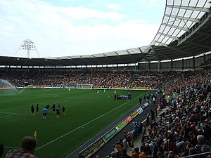
MKM Stadium
Sports stadium in Kingston upon Hull, England
Distance: Approx. 2031 meters
Latitude and longitude: 53.74611111,-0.36777778
The MKM Stadium is a multi-purpose stadium in Kingston upon Hull, England. It has a current capacity of 25,586. The stadium is home to both association football club Hull City A.F.C. of the EFL Championship and rugby league club Hull F.C. of the Super League.

Boothferry Park
Distance: Approx. 1611 meters
Latitude and longitude: 53.74042222,-0.38972778
Boothferry Park was a football stadium in Hull, England, which was home to Hull City A.F.C. from 1946 until 2002, when they moved to the KC Stadium. In later years, financial constraints forced Hull City to allow Kwik Save and Iceland supermarkets to embed themselves into the stadium's structure. Parts of the ground were demolished in early 2008, more than five years after the last game was played there, and the remainder in 2011.

The Boulevard (stadium)
Former stadium in Kingston upon Hull, England
Distance: Approx. 1295 meters
Latitude and longitude: 53.73944444,-0.36916667
The Boulevard was a multi-purpose stadium in Hull, England, from 1895 to 2010. The venue primarily hosted rugby league matches, speedway and greyhound racing.
Boothferry Park Halt railway station
Disused railway station in North Yorkshire, England
Distance: Approx. 1633 meters
Latitude and longitude: 53.7416,-0.387
Boothferry Park Halt railway station opened on 6 January 1951 on an embankment of the former Hull and Barnsley Railway to serve the Boothferry Park football stadium which had opened in Hull, East Riding of Yorkshire in August 1946. The station was first used for a match against Everton when six trains ran the football service between Hull Paragon and Boothferry Park. The station closed in 1986 for safety reasons.
The Circle (Kingston upon Hull)
Cricket ground in Kingston upon Hull
Distance: Approx. 2026 meters
Latitude and longitude: 53.74595556,-0.36714167
The Circle was a cricket ground on Anlaby Road in Kingston upon Hull, which hosted 89 first-class matches from 1899 to 1974. Two other matches were rained off without a ball being bowled. Most of the matches were County Championship games featuring Yorkshire County Cricket Club, but matches against touring teams from India, Australia, South Africa and University games were also played there.
Gipsyville
Suburb of Kingston upon Hull in the East Riding of Yorkshire, England
Distance: Approx. 865 meters
Latitude and longitude: 53.7313,-0.3881
Gipsyville is a western suburb of Kingston upon Hull, in the East Riding of Yorkshire, England. Gipsyville was established at the beginning of the 20th century as a housing and factory development and derives its name from a black lead product "Gipsy Black Metal Polish" that was produced locally at the Hargreaves & Bros company works. During the interwar period a large council estate of over 1,000 dwellings was built to the north of the original development.

Pickering Park, Kingston upon Hull
Distance: Approx. 1604 meters
Latitude and longitude: 53.7324,-0.3993
Pickering Park is a park in the western suburbs of Kingston upon Hull, on the north side of Hessle Road, near Anlaby, East Riding of Yorkshire, England.

Carnegie Heritage Centre
Grade II listed building in Hull, England
Distance: Approx. 1751 meters
Latitude and longitude: 53.7441,-0.3725
The Carnegie Heritage Centre is a grade II listed building in Hull, England, which was designed as a Carnegie library. Originally known as the Carnegie Free Library, the building opened in 1905 as Hull's fifth branch library. Andrew Carnegie donated £3,000 towards its construction.

Dairycoates
Area of Kingston upon Hull in the East Riding of Yorkshire, England
Distance: Approx. 338 meters
Latitude and longitude: 53.7309,-0.379
Dairycoates is an area of Kingston upon Hull, East Riding of Yorkshire, England, a former hamlet. The area was formerly the site of a major North Eastern Railway engine shed, Dairycoates Engine Shed (est.1862, closed 1970). Most of the Dairycoates area is now in industrial use, including the Brighton Street Industrial Estate, located on former rail use land.
The Boulevard Academy
Free school in Kingston upon Hull, East Riding of Yorkshire, England
Distance: Approx. 1342 meters
Latitude and longitude: 53.74002778,-0.36986111
The Boulevard academy is a coeducational secondary school located in Kingston upon Hull in the East Riding of Yorkshire, England. It opened as a free school in September 2013, and was rated as 'outstanding' by Ofsted in 2015.

Wenlock Barracks
Distance: Approx. 1729 meters
Latitude and longitude: 53.74403,-0.37546
Wenlock Barracks is a military installation on Anlaby Road in Kingston upon Hull, England.

Lagoon Hull
Proposed lagoon in the Humber Estuary, England
Distance: Approx. 606 meters
Latitude and longitude: 53.727,-0.367
Lagoon Hull is a proposed £1.5 billion development on the Humber Estuary foreshore between Hessle and Kingston upon Hull, in the East Riding of Yorkshire, England. The proposed lagoon would be formed from a stone causeway and will provide an outer lock gate in the Humber Estuary which would effectively dam the River Hull, making it a non-tidal waterway. The 11-kilometre (6.8 mi) long causeway would also provide a dual carriageway from the A63 at Hessle which would run to Hull Docks, taking traffic away from the city centre.
Weather in this IP's area
overcast clouds
16 Celsius
15 Celsius
15 Celsius
16 Celsius
1004 hPa
65 %
1004 hPa
1004 hPa
1000 meters
2.57 m/s
10 degree
100 %
06:23:15
19:35:17