Country:
 Germany
Region:
City:
Latitude and Longitude:
Time Zone:
Postal Code:
IP information under different IP Channel
ip-api
Country
Region
City
ASN
Time Zone
ISP
Blacklist
Proxy
Latitude
Longitude
Postal
Route
IPinfo
Country
Region
City
ASN
Time Zone
ISP
Blacklist
Proxy
Latitude
Longitude
Postal
Route
MaxMind
Country
Region
City
ASN
Time Zone
ISP
Blacklist
Proxy
Latitude
Longitude
Postal
Route
Luminati
Country
DEASN
Time Zone
Europe/Berlin
ISP
Host Europe GmbH
Latitude
Longitude
Postal
db-ip
Country
Region
City
ASN
Time Zone
ISP
Blacklist
Proxy
Latitude
Longitude
Postal
Route
ipdata
Country
Region
City
ASN
Time Zone
ISP
Blacklist
Proxy
Latitude
Longitude
Postal
Route
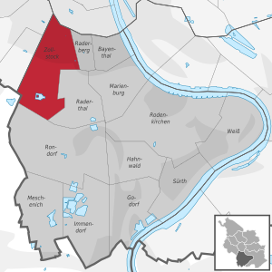
Popular places and events near this IP address

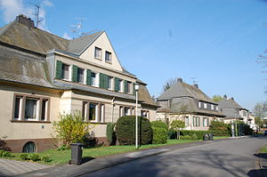
Hürth
Town in North Rhine-Westphalia, Germany
Distance: Approx. 1825 meters
Latitude and longitude: 50.8775,6.87611111
Hürth is a town in the Rhein-Erft-Kreis, North Rhine-Westphalia, Germany. Hürth shares borders with the city of Cologne and is about 6 km to the southwest of Cologne city centre, at the northeastern slope of the natural preserve Kottenforst-Ville. The town consists of thirteen districts, once independent villages, and is distributed over a relatively large area.
Toyota Gazoo Racing Europe
Motorsport and automotive research and development facility owned by Toyota
Distance: Approx. 4317 meters
Latitude and longitude: 50.9148623,6.8630095
Toyota Gazoo Racing Europe GmbH (TGR-E) is an automotive engineering and motorsport services facility based in Cologne, Germany. It is fully-owned and controlled by Toyota Motor Corporation. TGR-E's principal operation is technical development of motorsport vehicles and their competitive entries on behalf of Toyota's Gazoo Racing brand in the FIA's World Endurance Championship (WEC) and World Rally Championship (WRC).
St. George's The British International School
International school in Cologne, Duisburg, Munich
Distance: Approx. 3396 meters
Latitude and longitude: 50.87583333,6.94666667
St. George's School is an IB World School, for students from age 2-18. St George's is a private school and teaches the English National Curriculum (in form of IGCSE at Key Stage 4) and the IB Diploma Programme after Key Stage 4.
Knapsack, Germany
Distance: Approx. 4004 meters
Latitude and longitude: 50.86666667,6.85
Knapsack is a locality of Hürth, Rhine-Erft district, North Rhine-Westphalia, Germany. On Wednesday 17 October 2007, King Harald of Norway opened Statkraft's first gas power plant at Knapsack in Germany.
Cyril Ridley
British flying ace
Distance: Approx. 3083 meters
Latitude and longitude: 50.89805556,6.93777778
Flight Lieutenant Cyril Burfield Ridley (15 January 1895 – 17 May 1920) was a British World War I flying ace, who served in the Royal Naval Air Service and the Royal Air Force, before being killed in a flying accident in 1920.

Sülz
Municipal part of Cologne, Germany
Distance: Approx. 4106 meters
Latitude and longitude: 50.9175,6.92416667
Sülz (German pronunciation: [ˈzʏlts]; Kölsch: Sölz [zǿlts]) is a municipal part of Cologne, Germany and part of the district of Lindenthal. Sülz lies on Luxemburger Straße between Lindenthal and Klettenberg. Sülz has 35.475 inhabitants (as of 31 December 2008) and covers an area of 5,17 km2 (pop.
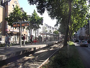
Sülzburgstraße station
Railway station in Germany
Distance: Approx. 3980 meters
Latitude and longitude: 50.91527778,6.92722222
Sülzburgstraße is a station on the Cologne Stadtbahn line 18, located in the Cologne district of Lindenthal. The station lies on Luxemburger Straße at its junction with the shopping street Sülzburgstraße, after which the station is named. The station was opened in 1898 and consists of one island platform with two rail tracks.

Hürth-Kalscheuren station
Railway station in Hürth, Germany
Distance: Approx. 1138 meters
Latitude and longitude: 50.87583333,6.91
Hürth-Kalscheuren station is in the town of Hürth in the Rhein-Erft district in the German state of North Rhine-Westphalia. It is at the junction of the Eifel Railway with the West Rhine Railway. The station was built in 1859 at the initiative of the city of Hürth, but was renamed Hürth-Kalscheuren in 1991/2 as a result of a contribution of Deutsche Mark 14,000 from Kalscheuren.

Army Office
Former command pillar of the German Army
Distance: Approx. 3719 meters
Latitude and longitude: 50.897363,6.948509
The Army Office (German: Heeresamt, HA) in Cologne was one of the two command pillars of the German Army, alongside the Army Forces Command (Heeresführungskommando, HFüKdo), until both were merged to create the current Army Command (Kommand Heer, KdoHeer). This disbandment and merging was done according to the new direction of the Bundeswehr, and the 2011 Basing Concept (Stationierungskonzept 2011). At the time of its merger, the Army Office was made up 1,100 soldiers and civil servants who were responsible for the conceptual development of the Army, as well as its training and equipment.
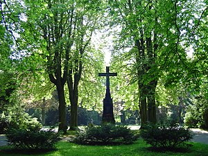
Südfriedhof (Cologne)
Cemetery in Germany
Distance: Approx. 3150 meters
Latitude and longitude: 50.89805556,6.93888889
Südfriedhof is the German name for the South Cemetery in Cologne, Germany. With an area of over 61 hectares, it is the largest cemetery in Cologne. Südfriedhof also has sections for 2,596 Commonwealth war graves from prisoners of war mainly from the First World War.

Friedhof Trenkebergstraße
Cemetery in Cologne, Germany
Distance: Approx. 3600 meters
Latitude and longitude: 50.85805556,6.93083333
Friedhof Trenkebergstraße is a cemetery in Cologne, Germany. The cemetery is 4,600 m2 and offers space for 790 graves. Furthermore, there are 16 graves in this cemetery for German victims of the Second World War.
Zollstock
District of Cologne
Distance: Approx. 4037 meters
Latitude and longitude: 50.90583333,6.94583333
Zollstock is a district (German: Stadtteil) of Cologne in the borough (German: Bezirk) of Rodenkirchen. Situated west of the river Rhine, Zollstock was first mentioned in 1877 and experienced increased development from the 1880s onwards. Since 1901, the district has housed the Südfriedhof, a large monumental cemetery.
Weather in this IP's area
few clouds
17 Celsius
17 Celsius
15 Celsius
19 Celsius
1024 hPa
81 %
1024 hPa
1018 hPa
10000 meters
1.54 m/s
20 %
07:14:23
19:37:56