Country:
Region:
City:
Latitude and Longitude:
Time Zone:
Postal Code:
IP information under different IP Channel
ip-api
Country
Region
City
ASN
Time Zone
ISP
Blacklist
Proxy
Latitude
Longitude
Postal
Route
Luminati
Country
Region
14
City
warsaw
ASN
Time Zone
Europe/Warsaw
ISP
Liberty Global B.V.
Latitude
Longitude
Postal
IPinfo
Country
Region
City
ASN
Time Zone
ISP
Blacklist
Proxy
Latitude
Longitude
Postal
Route
db-ip
Country
Region
City
ASN
Time Zone
ISP
Blacklist
Proxy
Latitude
Longitude
Postal
Route
ipdata
Country
Region
City
ASN
Time Zone
ISP
Blacklist
Proxy
Latitude
Longitude
Postal
Route
Popular places and events near this IP address

Wilanów
District of Warsaw in Masovian Voivodeship, Poland
Distance: Approx. 1162 meters
Latitude and longitude: 52.16666667,21.08333333
Wilanów (Polish pronunciation: [vʲiˈlanuf] ) is a district of the city of Warsaw, Poland. It is home to historic Wilanów Palace, the "Polish Versailles," and second home to various Polish kings. Wilanów is home to many villas and, despite being relatively far away from the city center, the district ranks among the most expensive in Warsaw.

Warsaw University of Life Sciences
Distance: Approx. 1329 meters
Latitude and longitude: 52.16166667,21.04805556
The Warsaw University of Life Sciences (Polish: Szkoła Główna Gospodarstwa Wiejskiego, lit. 'Main School of Rural Homestead', SGGW) is the largest agricultural university in Poland, established in 1816 in Warsaw. It employs over 2,600 staff including over 1,200 academic educators. The University is since 2005 a member of the Euroleague for Life Sciences (ELLS) which was established in 2001.

Wilanów Palace
Royal palace located in Warsaw, Poland
Distance: Approx. 1583 meters
Latitude and longitude: 52.16527778,21.09027778
Wilanów Palace (Polish: Pałac w Wilanowie, Polish pronunciation: [ˈpawad͡z v vilaˈnɔvjɛ]) is a former royal palace located in the Wilanów district of Warsaw, Poland. It was built between 1677–1696 for king of Poland John III Sobieski according to a design by architect Augustyn Wincenty Locci. Wilanów Palace survived Poland's partitions and both World Wars, and so serves as one of the most remarkable examples of Baroque architecture in the country.

Beit Warszawa Synagogue
Reform synagogue in Warsaw, Poland
Distance: Approx. 1514 meters
Latitude and longitude: 52.17527778,21.07694444
The Beit Warszawa Synagogue (Polish: Beit Warszawae Synagoge) is a Reform Jewish congregation and synagogue, located at 113 Wiertnicza Street, in the district of Wilanów, Warsaw, in the Masovian Voivodeship of Poland. Designed in the Modernist style and completed in 2003, the synagogue has regular events, including Friday night and Saturday morning prayers. Beit Warszawa is a member of Beit Polska, the umbrella organization for the Progressive and Reform Jewish community in Poland.

Temple of Divine Providence
Distance: Approx. 589 meters
Latitude and longitude: 52.1586,21.0722
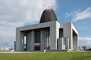
The Temple of Divine Providence (Polish: Świątynia Opatrzności Bożej) and Pantheon of Great Poles (in Polish, Panteon Wielkich Polaków, in southern Warsaw's Wilanów district, is a principal Roman Catholic church in Poland. The backstory of its construction began in the 18th century. The Temple is conceived as a national and religious symbol for Poland.

Poster Museum, Wilanów
Art museum in Warsaw, Poland
Distance: Approx. 1426 meters
Latitude and longitude: 52.16430556,21.08817778
The Poster Museum at Wilanów (Polish: Muzeum Plakatu w Wilanowie) is the world's oldest poster museum. Founded in 1968, the museum is housed at the Wilanów Palace complex in Warsaw, Poland.

Embassy of the Philippines, Warsaw
Diplomatic mission of the Philippines in Poland
Distance: Approx. 1271 meters
Latitude and longitude: 52.17295833,21.07651944
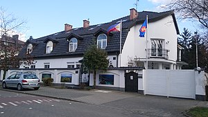
The Embassy of the Philippines in Warsaw is the diplomatic mission of the Republic of the Philippines to the Republic of Poland. It is located on ul. Stanisława Lentza 11 in the Wilanów district of south Warsaw, near the Wilanów Palace.
Museum of John Paul II and Primate Wyszyński
Museum in Warsaw, Poland
Distance: Approx. 589 meters
Latitude and longitude: 52.1586,21.0722
The Museum of John Paul II and Primate Wyszyński (Polish: Muzeum Jana Pawła II i Prymasa Wyszyńskiego) is a Roman Catholic cultural and educational institution affiliated with the Archdiocese of Warsaw, honoring two prominent Polish Catholic leaders: Saint John Paul II, the first Polish Pope, and Cardinal Stefan Wyszyński, the Archbishop of Warsaw and Gniezno and Primate of Poland. It was established by a decree of 18 May 2010 issued by Archbishop Kazimierz Nycz. The museum is located at the Temple of Divine Providence, which constitutes its integral part.

Willy Brandt School (Warsaw)
German international school in Poland
Distance: Approx. 614 meters
Latitude and longitude: 52.1576,21.0692
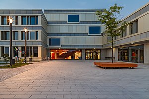
Deutsch-Polnische Begegnungsschule! „Willy-Brandt-Schule“ in Warschau (WBS, Polish: Polsko-Niemiecka Szkoła Spotkań i Dialogu im. Willy’ego Brandta w Warszawie) is a German international school with a 1-12 campus and a Kindergarten campus in Warsaw, Poland.
Wilanów Cemetery
Cemetery in Warsaw, Poland
Distance: Approx. 1160 meters
Latitude and longitude: 52.16777778,21.0825
Wilanów Cemetery also known as Cmentarz w Wilanowie is a Roman Catholic cemetery in Warsaw's Wilanów district. It is located at the intersection of Wiertnicza and Wilanowska streets.

Stary Służew
Neighbourhood in Warsaw, Poland
Distance: Approx. 1512 meters
Latitude and longitude: 52.16361111,21.04527778
Stary Służew is a neighbourhood, and a City Information System area, located in Warsaw, Poland, within the district of Ursynów. The area is dominated by single-family housing with an additional presence of multifamily housing. It includes the historical portion of the neighbourhood of Służew, including the 19th-century Krasiński Palace, Catholic St.

Krasiński Palace (Ursynów)
Palace in Warsaw, Poland
Distance: Approx. 1171 meters
Latitude and longitude: 52.164715,21.050478
The Krasiński Palace, also known as the Ursynów Palace, and Delight Palace, is a Renaissance Revival palace in Warsaw, Poland, located at 166 Nowoursynowska Street within the district of Ursynów. It was constructed in its current form between 1858 and 1860 for Krasiński family and designed by architect Zygmunt Rospendowski. The original place was built there in 1776 for the Potocki family.
Weather in this IP's area
clear sky
9 Celsius
5 Celsius
8 Celsius
10 Celsius
1027 hPa
47 %
1027 hPa
1016 hPa
10000 meters
7.2 m/s
270 degree
06:35:03
16:03:27
