Country:
Region:
City:
Latitude and Longitude:
Time Zone:
Postal Code:
IP information under different IP Channel
ip-api
Country
Region
City
ASN
Time Zone
ISP
Blacklist
Proxy
Latitude
Longitude
Postal
Route
Luminati
Country
Region
14
City
warsaw
ASN
Time Zone
Europe/Warsaw
ISP
Liberty Global B.V.
Latitude
Longitude
Postal
IPinfo
Country
Region
City
ASN
Time Zone
ISP
Blacklist
Proxy
Latitude
Longitude
Postal
Route
db-ip
Country
Region
City
ASN
Time Zone
ISP
Blacklist
Proxy
Latitude
Longitude
Postal
Route
ipdata
Country
Region
City
ASN
Time Zone
ISP
Blacklist
Proxy
Latitude
Longitude
Postal
Route
Popular places and events near this IP address

Sielce, Warsaw
Warsaw Neighborhood in Masovian Voivodeship, Poland
Distance: Approx. 670 meters
Latitude and longitude: 52.201334,21.039566
Sielce (Polish pronunciation: [ˈɕɛlt͡sɛ]) is a neighborhood in Mokotów district of Warsaw, Poland. Sielce is roughly bounded on the North by Podchorążych Street, the East by Czerniakowska Street, the South by Beethhovena Street, and the West by Sobieskiego Street. Its northwest corner adjoins the Royal Baths Park, also known as Park Łazienkowski, on the southwest side, with two entrances to the park (one from Gagarina Street, and one on Podchorążych).

Jurija Gagarina Street, Warsaw
Distance: Approx. 716 meters
Latitude and longitude: 52.20666667,21.04
Yuri Gagarin Street (ulica Jurija Gagarina) is a major street in the Mokotów district of Warsaw, named after the first man in space. Yuri Gagarin Street was established around 1957 as Nowoparkowa Street. It was established in the place of the streets of the former Sielce settlement, laid out at the turn of the 19th and 20th centuries.
National Institute of Public Health – National Institute of Hygiene
Distance: Approx. 939 meters
Latitude and longitude: 52.21087,21.023097
The National Institute of Public Health – National Institute of Hygiene or NIPH–NIH, (Polish: Narodowy Instytut Zdrowia Publicznego – Państwowy Zakład Higieny or NIZP–PZH) is a research institute in Poland focussed on public health. It was founded on 21 November 1918.

List of ambassadors of Uruguay to Poland
Distance: Approx. 956 meters
Latitude and longitude: 52.207247,21.017769
The Uruguayan ambassador in Warsaw is the official representative of the Government in Montevideo to the Government of Poland.

Miguel de Cervantes Liceum
Public school in Warsaw, Masovian Voivodeship, Poland
Distance: Approx. 700 meters
Latitude and longitude: 52.2049,21.0407
Miguel de Cervantes Liceum, officially the Miguel de Cervantes XXXIV General Education Liceum with Bilingual Branches in Warsaw, is a public general education liceum (secondary school) in Warsaw, Poland. In the years 1945-1991 was named the Karol Świerczewski Liceum.

Fort M-Che
Former fort in Warsaw, Poland
Distance: Approx. 905 meters
Latitude and longitude: 52.1975,21.02222222
The Fort M-Che, also known as Fort Mokotów-Czerniaków, and Fort Odyńca, was a fort which was a part of the inner circle of the series of fortifications of the Warsaw Fortress. It was built in 1892 by the Imperial Russian Army, in what is now the neighborhood of Wierzbno, in the city of Warsaw, Poland, located near current Czeczota Street and Odyńca Street. It was demilitarized and abandoned in 1909, and deconstructed in the 1920s.

Henryków, Mokotów
Neighbourhood in Warsaw, Poland
Distance: Approx. 873 meters
Latitude and longitude: 52.19666667,21.02527778
Henryków is a neighbourhood in the city of Warsaw, Poland, in the district of Mokotów. It is located within the City Information System area of Wierzbno, and partially within the municipal neighbourhood of Wierzbno. It is a residential area, mostly consisting of villas.

Dreszer Park
Urban park in Warsaw, Poland
Distance: Approx. 954 meters
Latitude and longitude: 52.1975,21.02111111
The General Gustaw Orlicz-Dreszer Park, also simply known as Dreszer Park, is an urban park in the city of Warsaw, Poland, in the district of Mokotów. It is located between Ursynowska Street, Puławska Street, Odyńca Street, and Krasickiego Street. The park was designed by Zygmunt Hellwig, and opened in 1938.

Eye of the Sea (Warsaw)
Artificial lake in Warsaw, Poland
Distance: Approx. 480 meters
Latitude and longitude: 52.206296,21.024865
The Eye of the Sea (Polish: Morskie Oko) is an artificial pond in Warsaw, Poland, located within the district of Mokotów in the Eye of the Sea Park.

Eye of the Sea Park
Urban park in Warsaw, Poland
Distance: Approx. 476 meters
Latitude and longitude: 52.20611111,21.02472222
The Eye of the Sea Park (Polish: Park Morskie Oko) is an urban park in Warsaw, Poland. It is located in the neighbourhoods of Old Mokotów and Sielce, within the district of Mokotów, between Puławska Street, Dworkowa Street, Morskie Oko Street, Promenada Street, Belwederska Street, Zajączkowska Street, and Spacerowa Street. It has the total area of 17.9 ha.

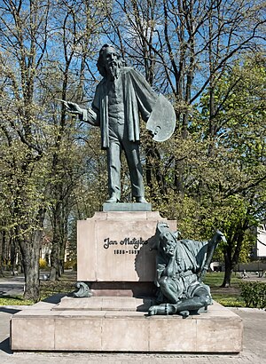
Jan Matejko Monument (Warsaw)
Monument in Warsaw, Poland
Distance: Approx. 480 meters
Latitude and longitude: 52.20368333,21.02357222
The Jan Matejko Monument is a monument in Warsaw, Poland, located in the Eye of the Sea Park within the district of Mokotów. It depicts Jan Matejko, a 19th century painter. The work was designed by Marian Konieczny and unveiled in 1994.

Sielce Park
Urban park in Warsaw, Poland
Distance: Approx. 852 meters
Latitude and longitude: 52.19945,21.04086944
The Sielce Park (Polish: Park Sielecki) is an urban park in Warsaw, Poland. It is located in the neighbourhood of Sielce, within the district of Mokotów, and placed around the Sielce Lake, and next to Jana III Sobieskiego Avenue. The park was originally opened in 1775 as an English landscape garden, and was developed to its current form in the 1960s.
Weather in this IP's area
light rain
3 Celsius
-2 Celsius
3 Celsius
4 Celsius
1032 hPa
84 %
1032 hPa
1021 hPa
10000 meters
8.05 m/s
280 degree
10 %
06:37:09
16:01:42