Country:
 Poland
Region:
City:
Latitude and Longitude:
Time Zone:
Postal Code:
IP information under different IP Channel
ip-api
Country
Region
City
ASN
Time Zone
ISP
Blacklist
Proxy
Latitude
Longitude
Postal
Route
IPinfo
Country
Region
City
ASN
Time Zone
ISP
Blacklist
Proxy
Latitude
Longitude
Postal
Route
MaxMind
Country
Region
City
ASN
Time Zone
ISP
Blacklist
Proxy
Latitude
Longitude
Postal
Route
Luminati
Country
PLRegion
14
City
radom
ASN
Time Zone
Europe/Warsaw
ISP
Liberty Global B.V.
Latitude
Longitude
Postal
db-ip
Country
Region
City
ASN
Time Zone
ISP
Blacklist
Proxy
Latitude
Longitude
Postal
Route
ipdata
Country
Region
City
ASN
Time Zone
ISP
Blacklist
Proxy
Latitude
Longitude
Postal
Route
Popular places and events near this IP address
Ochota
District in Warsaw, Poland
Distance: Approx. 1020 meters
Latitude and longitude: 52.21638889,20.98111111
Ochota (Polish pronunciation: [ɔˈxɔta] ) is a district of Warsaw, Poland, located in the central part of the city's urban agglomeration. It is Warsaw's most densely populated district and home to the scientific campus of the University of Warsaw.

Zesłańców Syberyjskich Roundabout, Warsaw
Distance: Approx. 393 meters
Latitude and longitude: 52.21638889,20.96055556
The Zesłańców Syberyjskich Roundabout (Polish: Rondo Zesłańców Syberyjskich; literally: Siberian Exiles) is a roundabout in western Warsaw's Ochota district, named after Poles who have been exiled to Siberia. The following streets meet at Sybirak Roundabout: on the east, Jerusalem Avenue (aleje Jerozolimskie); on the west, Jerusalem Avenue (aleje Jerozolimskie); on the north, Millennial Primate Avenue (aleja Prymasa Tysiąclecia); on the south, 1920 Battle of Warsaw Street (ulica Bitwy Warszawskiej 1920 roku).
Ochota massacre
1944 Nazi massacre in Warsaw, Poland
Distance: Approx. 855 meters
Latitude and longitude: 52.21,20.971
The Ochota Massacre (in Polish: Rzeź Ochoty – "Ochota slaughter") was a wave of German-orchestrated mass murder, looting, arson, torture and rape, which swept through the Warsaw district of Ochota from 4–25 August 1944, during the Warsaw Uprising. The principal perpetrators of these war crimes were the Nazi collaborationist S.S. Sturmbrigade R.O.N.A., the so-called "Russian National Liberation Army" (Russian: Русская Освободительная Народная Армия, RONA), commanded by Bronislav Kaminski. The worst atrocities were committed in the local hospitals, in the Curie Institute, the Kolonia Staszica housing estate, and the Zieleniak concentration camp.

Warszawa Zachodnia station
Railway station in Warsaw, Poland
Distance: Approx. 359 meters
Latitude and longitude: 52.22027778,20.96527778
Warszawa Zachodnia station, in English Warsaw West, is a railway and long-distance bus station in Warsaw, Poland on the border of Ochota and Wola districts. The railway station is the westernmost terminus of the Warsaw Cross-City Line. It serves trains from PKP Intercity, Polregio, Koleje Mazowieckie, Szybka Kolej Miejska and Warszawska Kolej Dojazdowa as well as international trains passing through Warsaw.

Warsaw Icon Museum
Museum in Warsaw, Poland
Distance: Approx. 614 meters
Latitude and longitude: 52.21663889,20.97516667
The Warsaw Icon Museum (Polish: Muzeum Ikon w Warszawie) is the first museum in Warsaw and the third in Poland dedicated to icons. Located in the Ochota district of Warsaw, Poland, the museum is housed in a former boilerhouse.

Institute for Legacy of Polish National Thought
Polish educational and historical research institute
Distance: Approx. 606 meters
Latitude and longitude: 52.21166667,20.96555556
The Roman Dmowski and Ignacy Jan Paderewski Institute for the Legacy of Polish National Thought is a Polish educational and historical research institute. Announced to appear at a press conference on 3 February 2020, it was formally inaugurated by the Minister of Culture and National Heritage, Piotr Gliński, on 17 February that year. Its stated goal is to conduct research in the history of Poland through the lens of political philosophy, with most attention devoted to the analyses on Catholic, conservative and National Democratic thought, though some have raised doubts about the true purpose and impartiality of the organisation.

Och-Teatr
Theater in Warsaw, Poland
Distance: Approx. 1005 meters
Latitude and longitude: 52.214199,20.980147
Och-Teatr is a privately owned performing arts theater located in Ochota, Warsaw. It was founded in 2010 by Krystyna Janda's Foundation for Culture. It has a total of 554 seats, 100 of which are unnumbered in the smaller Och-Cafe Theater section.

Blue City (Warsaw)
Shopping centre in Warsaw, Poland
Distance: Approx. 858 meters
Latitude and longitude: 52.21269444,20.95588333
Blue City is a postmodernist shopping centre in Warsaw, Poland, located at 179 Jerusalem Avenue within the district of Ochota. It was opened in 2004.

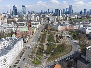
Five Sisters Park
Urban park in Warsaw, Poland
Distance: Approx. 58 meters
Latitude and longitude: 52.21666667,20.96666667
The Five Sisters Park, also known as the Western Park, is an urban park in Warsaw, Poland, located in the district of Ochota, at the intersection of Jerusalem Avenue and Bitwy Warszawskiej 1920 roku Street. It was opened in 2020.

Defense of Ochota and Wola (1939)
Military actions undertaken by the Polish Army during the invasion of Poland
Distance: Approx. 1004 meters
Latitude and longitude: 52.21026,20.9758
The defense of Ochota and Wola refers to military actions undertaken by the Polish Army on 8–9 September 1939 during the September campaign, in the districts of Ochota and Wola in Warsaw. The result was the repulsion of the German assault by the 4th Panzer Division and thus the thwarting of the German plan for a rapid capture of the Polish capital. On 8 September 1939, German tanks reached the outskirts of Warsaw.

Good Maharaja Square
Garden square in Warsaw, Poland
Distance: Approx. 809 meters
Latitude and longitude: 52.210432,20.970909
The Good Maharaja Square (Polish: Skwer Dobrego Maharadży), also known as the Opacz Park (Polish: Park Opaczewski), is a garden square in Warsaw, Poland, located in the district of Ochota, between Grójecka, Opaczewska Street, and Szczęśliwicka Streets.

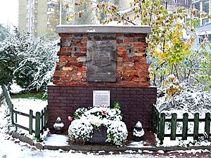
September Barricade Monument
Monument in Warsaw, Poland
Distance: Approx. 1009 meters
Latitude and longitude: 52.210259,20.975908
The September Barricade Monument (Polish: Pomnik Barykada Września) is a brutalist mounument in Warsaw, Poland. It is located in the district of Ochota, at Grójecka Street, near the intersection with Opaczewska Street. The monument commemorates a barricade that was constructed by the Polish Armed Forces during the Siege of Warsaw, and used between 8 and 27 September 1939.
Weather in this IP's area
clear sky
11 Celsius
10 Celsius
11 Celsius
13 Celsius
1026 hPa
57 %
1026 hPa
1013 hPa
10000 meters
5.66 m/s
140 degree
07:06:40
17:35:28