Country:
 Poland
Region:
City:
Latitude and Longitude:
Time Zone:
Postal Code:
IP information under different IP Channel
ip-api
Country
Region
City
ASN
Time Zone
ISP
Blacklist
Proxy
Latitude
Longitude
Postal
Route
IPinfo
Country
Region
City
ASN
Time Zone
ISP
Blacklist
Proxy
Latitude
Longitude
Postal
Route
MaxMind
Country
Region
City
ASN
Time Zone
ISP
Blacklist
Proxy
Latitude
Longitude
Postal
Route
Luminati
Country
PLRegion
14
City
radom
ASN
Time Zone
Europe/Warsaw
ISP
Liberty Global B.V.
Latitude
Longitude
Postal
db-ip
Country
Region
City
ASN
Time Zone
ISP
Blacklist
Proxy
Latitude
Longitude
Postal
Route
ipdata
Country
Region
City
ASN
Time Zone
ISP
Blacklist
Proxy
Latitude
Longitude
Postal
Route
Popular places and events near this IP address
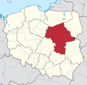
Masovian Voivodeship
Voivodeship of Poland
Distance: Approx. 657 meters
Latitude and longitude: 52.21666667,21
Masovian Voivodeship or Mazowieckie Province or Mazowieckie Voivodeship or Mazovian Voivodeship or Mazovian Province, etc. (Polish: województwo mazowieckie, pronounced [vɔjɛˈvut͡stfɔ mazɔˈvjɛt͡skʲɛ] ) is a voivodeship (province) in east-central Poland, containing Poland's capital Warsaw. Masovian Voivodeship has an area of 35,579 square kilometres (13,737 sq mi) and had a 2019 population of 5,411,446, making it Poland's largest and most populous province.

Mokotów Field
Park in Warsaw, Poland
Distance: Approx. 75 meters
Latitude and longitude: 52.21083333,21
Mokotów Field (Polish: Pole Mokotowskie) is a large park in Warsaw, Poland. A part of the parkland is called the Marshal Józef Piłsudski Park. Located between Warsaw's Mokotów district and the city center, the park is one of the largest in Warsaw.

SGH Warsaw School of Economics
Polish business school
Distance: Approx. 714 meters
Latitude and longitude: 52.20888889,21.00888889
SGH Warsaw School of Economics (Polish: Szkoła Główna Handlowa w Warszawie, SGH) is the oldest and most prestigious business school in Poland. SGH Warsaw School of Economics was founded in 1906 as a private school named August Zieliński Private Trade Courses for Men. On 30 July 1919, it became a separate legal entity and was granted the status of an institution of higher education.
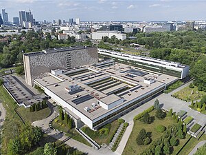
National Library of Poland
Central Polish library
Distance: Approx. 555 meters
Latitude and longitude: 52.21444444,21.00444444
The National Library (Polish: Biblioteka Narodowa) is the central Polish library, subject directly to the Ministry of Culture and National Heritage of the Republic of Poland. The library collects books, journals, electronic and audiovisual publications published in the territory of Poland, as well as Polonica published abroad. It is the most important humanities research library, the main archive of Polish writing and the state centre of bibliographic information about books.

Nazi war crimes in occupied Poland during World War II
WWII war crimes
Distance: Approx. 657 meters
Latitude and longitude: 52.21666667,21
Crimes against the Polish nation committed by Nazi Germany and Axis collaborationist forces during the invasion of Poland, along with auxiliary battalions during the subsequent occupation of Poland in World War II, included the genocide of millions of Polish people, especially the systematic extermination of Jewish Poles. These mass killings were enacted by the Nazis with further plans that were justified by their racial theories, which regarded Poles and other Slavs, and especially Jews, as racially inferior Untermenschen. By 1942, the Nazis were implementing their plan to murder every Jew in German-occupied Europe, and had also developed plans to reduce the Polish people through mass murder, ethnic cleansing, enslavement and extermination through labor, and assimilation into German identity of a small minority of Poles deemed "racially valuable".

Pole Mokotowskie metro station
Warsaw metro station
Distance: Approx. 653 meters
Latitude and longitude: 52.20861111,21.00777778
Metro Pole Mokotowskie is a station on Line M1 of the Warsaw Metro, located in the Mokotów district of Warsaw. It is named after the Pole Mokotowskie park nearby. It is located very close to the Warsaw School of Economics.

Patent Office of the Republic of Poland
Distance: Approx. 597 meters
Latitude and longitude: 52.2125,21.0072
The Polish Patent Office (PPO; Polish: Urząd Patentowy Rzeczypospolitej Polskiej, UPRP) is the patent office of Poland. It is based in Warsaw.

Republic of Zakopane
Unrecognized state (1918)
Distance: Approx. 657 meters
Latitude and longitude: 52.21666667,21
The Republic of Zakopane (or Commonwealth of Zakopane; Polish: Rzeczpospolita Zakopiańska) refers to an area in Galicia centered on the city of Zakopane that created its own parliament ("National Organisation") on October 13, 1918. The parliament's principal goal was to join an independent state of Poland. On October 30, the Organisation officially declared its independence from Austria-Hungary and, two days later, made itself a "National Council".
Cumann Warsaw
Gaelic Athletic Association club in Poland
Distance: Approx. 335 meters
Latitude and longitude: 52.211,20.994
Cumann Warsaw (Cumann Warszawa) is a GAA club in Warsaw, Poland. The club has joint hurling and Gaelic football sessions once a week at Pole Mokotowskie, with winter training taking place indoors at the nearby Stadion Skra.
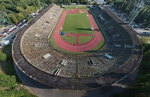
RKS Skra Stadium
Football and athletics stadium in Warsaw, Poland
Distance: Approx. 614 meters
Latitude and longitude: 52.215,20.99305556
The RKS Skra Stadium (Polish: Stadion RKS Skra) is a historic football and athletics stadium in Mokotów Field, Warsaw, Poland. It is currently used mostly for rugby union matches as the home stadium of Skra Warsaw. The stadium has a capacity of 35,000 people, but has been closed since October 2019.

Massacre in the Jesuit monastery on Rakowiecka Street, Warsaw
Nazi German war crime
Distance: Approx. 575 meters
Latitude and longitude: 52.2057,21.0002
The Massacre in the Jesuit monastery on Rakowiecka Street in Warsaw was a Nazi German war crime perpetrated by members of the Waffen-SS on the second day of the Warsaw Uprising, during the Second World War. On 2 August 1944 about 40 Poles were murdered and their bodies burnt in the basement of the Jesuit monastery at 61 Rakowiecka Street in Warsaw. Among the victims were 16 priests and religious brothers of the Society of Jesus.

Happy Dog Monument
Statue in Warsaw, Poland
Distance: Approx. 419 meters
Latitude and longitude: 52.21111111,20.99277778
The Happy Dog Monument (Polish: Pomnik Szczęśliwego Psa) is a statue of a Golden Retriever dog in Warsaw, Poland, placed in the Mokotów Field park complex, within the district of Ochota. It was designed by Bogna Czechowska, and unveiled on 2 October 2004.
Weather in this IP's area
clear sky
10 Celsius
6 Celsius
9 Celsius
11 Celsius
1026 hPa
61 %
1026 hPa
1013 hPa
10000 meters
9.39 m/s
130 degree
07:06:32
17:35:21