Country:
 Poland
Region:
City:
Latitude and Longitude:
Time Zone:
Postal Code:
IP information under different IP Channel
ip-api
Country
Region
City
ASN
Time Zone
ISP
Blacklist
Proxy
Latitude
Longitude
Postal
Route
IPinfo
Country
Region
City
ASN
Time Zone
ISP
Blacklist
Proxy
Latitude
Longitude
Postal
Route
MaxMind
Country
Region
City
ASN
Time Zone
ISP
Blacklist
Proxy
Latitude
Longitude
Postal
Route
Luminati
Country
PLRegion
14
City
warsaw
ASN
Time Zone
Europe/Warsaw
ISP
Liberty Global B.V.
Latitude
Longitude
Postal
db-ip
Country
Region
City
ASN
Time Zone
ISP
Blacklist
Proxy
Latitude
Longitude
Postal
Route
ipdata
Country
Region
City
ASN
Time Zone
ISP
Blacklist
Proxy
Latitude
Longitude
Postal
Route
Popular places and events near this IP address

Lublin County
County in Lublin Voivodeship, Poland
Distance: Approx. 385 meters
Latitude and longitude: 51.24805556,22.57027778
Lublin County (Polish: Powiat Lubelski) is a unit of territorial administration and local government (powiat) in Lublin Voivodeship, eastern Poland. It was established on January 1, 1999, as a result of the Polish local government reforms passed in 1998. Its administrative seat is the city of Lublin, although the city is not part of the county (it constitutes a separate city county).

Lublin Castle
Building in Lublin, Poland
Distance: Approx. 318 meters
Latitude and longitude: 51.25055556,22.57222222
The Lublin Castle (Polish: Zamek Lubelski) is a medieval castle in Lublin, Poland, adjacent to the Old Town district and close to the city center. It is one of the oldest preserved royal residencies in Poland, initially established by High Duke Casimir II the Just. Its contemporary Gothic Revival appearance is largely due to a reconstruction undertaken in the 19th century.
Missionary Church and Monastery, Lublin
Distance: Approx. 615 meters
Latitude and longitude: 51.24507778,22.56903333
Post-missionary church and monastery in Lublin - the church of the Transfiguration of Our Lord in Lublin was erected in the years 1717–1730 for a seminary of the Congregation of the Mission, after the suppression of the monastery by Russians during the time of the Partitions of Poland taken over by the diocese. It was built in the Baroque style, laid out on the plan of a Greek cross with a cupola above the transept. The 19th century neo-Gothic chapel adjacent to the church has a modern iconostasis designed by Jerzy Nowosielski and is today used by Greek Catholic alumni.

Lublin Ghetto
Nazi ghetto in Lublin, German-occupied Poland
Distance: Approx. 563 meters
Latitude and longitude: 51.25304,22.57155
The Lublin Ghetto was a World War II ghetto created by Nazi Germany in the city of Lublin on the territory of General Government in occupied Poland. The ghetto inmates were mostly Polish Jews, although a number of Roma were also brought in. Set up in March 1941, the Lublin ghetto was one of the first Nazi-era ghettos slated for liquidation during the deadliest phase of the Holocaust in occupied Poland.

National Museum, Lublin
Museum in Lublin, Poland
Distance: Approx. 318 meters
Latitude and longitude: 51.25055556,22.57222222
The National Museum in Lublin (Polish: Muzeum Narodowe w Lublinie) is one of the oldest and largest museums in Eastern Poland, located in Lublin. It was created in 1914, and received its own building in 1923.

Old Jewish Cemetery, Lublin
Jewish cemetery in Lublin, Poland
Distance: Approx. 461 meters
Latitude and longitude: 51.25222222,22.57916667
The Old Jewish Cemetery (Polish: Stary Cmentarz Żydowski w Lublinie), in Lublin, Poland, is located on a hill between Kalinowszczyzna and Sienna Streets. The cemetery overlooks the Old Town and is entirely surrounded by a high, seventeenth-century wall. It is located on the site of a former medieval fortress, and was once surrounded by numerous backwaters.
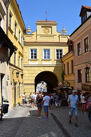
Grodzka Gate – NN Theatre
Distance: Approx. 425 meters
Latitude and longitude: 51.24944444,22.56972222
The "Grodzka Gate – NN Theatre" Centre (Polish: Ośrodek "Brama Grodzka — Teatr NN") is a cultural institution based in Lublin. It is housed in the Grodzka Gate also known as the Jewish Gate that historically used to be a passage from the Christian to the Jewish part of the city. In its activities the Center focuses on issues of cultural heritage.

The House of Words
Typography museum in Poland
Distance: Approx. 623 meters
Latitude and longitude: 51.24611111,22.56777778
The House of Words (pol. Dom Słów, formerly known as Chamber of Printing) – museum of typography in Poland, is a multimodal education center. It familiarizes audience with poetry and art, old techniques of printing, and the history and achievements of Lublin printing industry.

St. John the Baptist Cathedral, Lublin
Church in Lublin, Poland
Distance: Approx. 544 meters
Latitude and longitude: 51.2468,22.5685
The Cathedral of Saint John the Baptist (Polish: Archikatedra św. Jana Chrzciciela ) or simply Lublin Cathedral in Lublin, Poland is the cathedral church of the Roman Catholic Archdiocese of Lublin. It was built between 1592 and 1617 as a church of the Society of Jesus.

Chapel of the Holy Trinity, Lublin Castle
Building in Lublin, Poland
Distance: Approx. 254 meters
Latitude and longitude: 51.25030556,22.57311111
The Chapel of the Holy Trinity (Polish: Kaplica Trójcy Świętej), also known as Lublin Castle Chapel (Kaplica Zamkowa), is a Gothic chapel with a Renaissance gable located within the courtyard of Lublin Castle in Lublin, Poland. The chapel adjoins the museum of the castle complex and is an integral part of the site. It is known for its fifteenth-century frescoes in the Byzantine or Orthodox style, unusual for Catholic Poland.
Maharshal's Synagogue
Destroyed synagogue in Lublin, Poland
Distance: Approx. 362 meters
Latitude and longitude: 51.25111111,22.57222222
The Maharshal's Synagogue (Polish: Synagoga Maharszala), also known as the Great Lublin Synagogue (Yiddish: מהרשל־שול), was a former Orthodox Jewish congregation and synagogue, that was located on the northern slope of castle hill at the now nonexistent 3 Jateczna Street, in Lublin, in the Lublin Voivodeship of Poland. The synagogue served as a house of prayer until World War II when it was destroyed by Nazis in 1942. It was the largest synagogue in Lublin, and was the oldest known building in Poland with a four-pillar bema.

Cathedral of the Transfiguration, Lublin
Orthodox cathedral in Lublin, Poland
Distance: Approx. 415 meters
Latitude and longitude: 51.25225,22.57386111
Cathedral of the Transfiguration is an Orthodox cathedral in Lublin, and the main church of the Diocese of Lublin and Chełm of the Polish Orthodox Church. It also serves as the seat of the Lublin Parish of the Transfiguration (in the Lublin Deanery). The cathedral is located on Ruska Street.
Weather in this IP's area
clear sky
12 Celsius
12 Celsius
12 Celsius
13 Celsius
1027 hPa
90 %
1027 hPa
1007 hPa
10000 meters
2.57 m/s
70 degree
06:11:29
18:35:27