Country:
 Poland
Region:
City:
Latitude and Longitude:
Time Zone:
Postal Code:
IP information under different IP Channel
ip-api
Country
Region
City
ASN
Time Zone
ISP
Blacklist
Proxy
Latitude
Longitude
Postal
Route
IPinfo
Country
Region
City
ASN
Time Zone
ISP
Blacklist
Proxy
Latitude
Longitude
Postal
Route
MaxMind
Country
Region
City
ASN
Time Zone
ISP
Blacklist
Proxy
Latitude
Longitude
Postal
Route
Luminati
Country
PLRegion
14
City
warsaw
ASN
Time Zone
Europe/Warsaw
ISP
Liberty Global B.V.
Latitude
Longitude
Postal
db-ip
Country
Region
City
ASN
Time Zone
ISP
Blacklist
Proxy
Latitude
Longitude
Postal
Route
ipdata
Country
Region
City
ASN
Time Zone
ISP
Blacklist
Proxy
Latitude
Longitude
Postal
Route
Popular places and events near this IP address

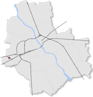
Włochy
Warsaw District in Masovian Voivodeship, Poland
Distance: Approx. 496 meters
Latitude and longitude: 52.2,20.91666667
Włochy (Polish pronunciation: [ˈvwɔxɨ] ) is one of the districts of Warsaw, located in the south-western part of city. Włochy borders districts Bemowo and Wola from the north, Ochota and Mokotów from the east, and Ursus and Ursynów from the south. It is one of 3 neighborhoods with the title of a garden town (pol.

LOT Polish Airlines Flight 007
1980 Polish aviation accident
Distance: Approx. 2280 meters
Latitude and longitude: 52.18513889,20.94619444
LOT Polish Airlines Flight 007 was an Ilyushin Il-62 that crashed near Okęcie Airport in Warsaw, Poland, on 14 March 1980, as the crew aborted a landing and attempted to go-around. All 87 crew and passengers died. It was caused by the disintegration of one of the turbine discs in one of the plane's engines, leading to uncontained engine failure.

Warszawa Włochy railway station
Railway station in Warsaw, Poland
Distance: Approx. 866 meters
Latitude and longitude: 52.20611111,20.91527778
Warszawa Włochy railway station is a railway station in the Włochy district of Warsaw, Poland. It stands on the junction of lines 1 and 3: from here trains can either run on Line 1 towards Łódź or Line 3 towards Poznań. It comprises two platforms connected by an underground pedestrian tunnel and a station building complete with ticket machines and bicycle parking.

Warszawa Reduta Ordona railway station
Railway station in Warsaw, Poland
Distance: Approx. 2271 meters
Latitude and longitude: 52.21444444,20.94805556
Warszawa Reduta Ordona railway station is a railway station that lies between the Ochota and Wola districts of Warsaw, Poland. It serves the Warszawska Kolej Dojazdowa system and was built in 1974 when Warszawska Kolej Dojazdowa was realigned into the city centre along its present line.

Warszawa Aleje Jerozolimskie railway station
Railway station in Warsaw, Poland
Distance: Approx. 1319 meters
Latitude and longitude: 52.20611111,20.94083333
Warszawa Aleje Jerozolimskie railway station is a railway station in the Ochota district of Warsaw, Poland. The station is built on a viaduct of Aleje Jerozolimskie. It handles trains from Warszawska Kolej Dojazdowa, from Warszawa Śródmieście WKD to Grodzisk Mazowiecki Radońska and Milanówek Grudów, and Koleje Mazowieckie, from Warszawa Wschodnia via Radom to Góra Kalwaria and Skarzysko Kamienna.
Warszawa Ursus Północny railway station
Railway station in Warsaw, Poland
Distance: Approx. 2401 meters
Latitude and longitude: 52.20555556,20.88972222
Warszawa Ursus Północny railway station is a railway station in the Ursus district of Warsaw, Poland. The station is served by Koleje Mazowieckie, who run trains from Kutno to Warszawa Wschodnia.
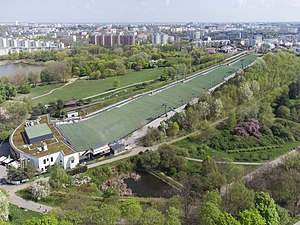
Szczęśliwice Hill
Distance: Approx. 2330 meters
Latitude and longitude: 52.205,20.957222
Szczęśliwice Hill (Polish: Górka Szczęliwicka) is an artificially created hill with a height of 152 metres (499 ft) above sea level. It is in Szczęśliwice Park, in the western part of Warsaw's Ochota district and it is the highest hill in the city. The biggest attraction of the hill is skiing at the Szczęśliwice Centre.

Salomea, Warsaw
Neighbourhood and a Municipal Information System area in Warsaw, Masovian Voivodeship, Poland
Distance: Approx. 1199 meters
Latitude and longitude: 52.18976667,20.92672222
Salomea is a neighbourhood, and an area of the Municipal Information System, in the city of Warsaw, Poland, located within the district of Włochy.

Wiktoryn, Warsaw
Neighbourhood of Warsaw, Poland
Distance: Approx. 703 meters
Latitude and longitude: 52.20361111,20.93277778
Wiktoryn is a residential neighbourhood in the city of Warsaw, Poland, located within the district of Włochy, in the City Information System area of Stare Włochy.

Opacz Wielka
Neighbourhood of Warsaw, Poland
Distance: Approx. 2094 meters
Latitude and longitude: 52.18166667,20.92111111
Opacz Wielka is a neighbourhood, and City Information System area, in the city of Warsaw, Poland. It is a residential area consisting of single-family detached homes. The oldest records that mention it date to the early 16th century.

Atrium Reduta
Shopping centre in Warsaw, Poland
Distance: Approx. 2369 meters
Latitude and longitude: 52.21362778,20.9511
Atrium Reduta, formerly known as Reduta, is a shopping centre in Warsaw, Poland, located at 148 Jerusalem Avenue within the district of Ochota. It was opened in 1999.

Centrum Łopuszańska 22
Shopping centre in Warsaw, Poland
Distance: Approx. 2099 meters
Latitude and longitude: 52.19194444,20.95138889
Centrum Łopuszańska 22 is a shopping centre in Warsaw, Poland, located at 22 Łopuszańska Street, within the district of Włochy. It was opened in 2015.
Weather in this IP's area
clear sky
16 Celsius
15 Celsius
13 Celsius
16 Celsius
1028 hPa
71 %
1028 hPa
1015 hPa
10000 meters
3.09 m/s
80 degree
06:17:45
18:42:24