Country:
 Poland
Region:
City:
Latitude and Longitude:
Time Zone:
Postal Code:
IP information under different IP Channel
ip-api
Country
Region
City
ASN
Time Zone
ISP
Blacklist
Proxy
Latitude
Longitude
Postal
Route
IPinfo
Country
Region
City
ASN
Time Zone
ISP
Blacklist
Proxy
Latitude
Longitude
Postal
Route
MaxMind
Country
Region
City
ASN
Time Zone
ISP
Blacklist
Proxy
Latitude
Longitude
Postal
Route
Luminati
Country
PLRegion
14
City
warsaw
ASN
Time Zone
Europe/Warsaw
ISP
Liberty Global B.V.
Latitude
Longitude
Postal
db-ip
Country
Region
City
ASN
Time Zone
ISP
Blacklist
Proxy
Latitude
Longitude
Postal
Route
ipdata
Country
Region
City
ASN
Time Zone
ISP
Blacklist
Proxy
Latitude
Longitude
Postal
Route
Popular places and events near this IP address

Warsaw concentration camp
Nazi concentration camp in Warsaw during World War II
Distance: Approx. 542 meters
Latitude and longitude: 52.24841667,20.98991667
The Warsaw concentration camp (German: Konzentrationslager Warschau, KL Warschau; see other names) was a German concentration camp in occupied Poland during World War II. It was formed on the base of the now-nonexistent Gęsiówka prison, in what is today the Warsaw neighbourhood of Muranów, on the order of Reichsführer-SS Heinrich Himmler. The camp operated from July 1943 to August 1944. Located in the ruins of the Warsaw Ghetto, KL Warschau first functioned as a camp in its own right, but was demoted to a branch of the Majdanek concentration camp in May 1944.

Gęsiówka
Former prison and Nazi concentration camp in Warsaw, Poland
Distance: Approx. 427 meters
Latitude and longitude: 52.24463889,20.97893889
Gęsiówka (Polish pronunciation: [ɡɛ̃ˈɕufka]) is the colloquial Polish name for a prison that once existed on Gęsia ("Goose") Street in Warsaw, Poland, and which, under German occupation during World War II, became a Nazi concentration camp. In 1945–56 the Gęsiówka served as a prison and labor camp, operated first by the Soviet NKVD to imprison Polish resistance fighters of the Home Army and other opponents of Poland's new Stalinist regime, then by the Polish communist secret police.

Pawiak
Prison built in 1835 in Warsaw, Poland
Distance: Approx. 421 meters
Latitude and longitude: 52.24638889,20.99055556
Pawiak (Polish pronunciation: [ˈpavjak]) was a prison built in 1835 in Warsaw, Congress Poland. During the January 1863 Uprising, it served as a transfer camp for Poles sentenced by Imperial Russia to deportation to Siberia. During the World War II German occupation of Poland, it was used by the Germans, and in 1944 it was destroyed in the Warsaw Uprising.

Pawiak Prison Museum
History museum in Warsaw, Poland
Distance: Approx. 421 meters
Latitude and longitude: 52.24638889,20.99055556
Muzeum Więzienia "Pawiak" (Museum of Pawiak Prison) is a museum in Warsaw, Poland, established in 1965. It shows the history of Pawiak Prison which was notably used during the German occupation between 1939 and 1944.

St. Augustine's Church, Warsaw
Church in Warsaw, Poland
Distance: Approx. 233 meters
Latitude and longitude: 52.244444,20.988611
The Church of St Augustine is a Roman Catholic church at 18 Nowolipki Street, in Wola, Warsaw, which was built in neo-Romanesque style.

Monument to Victims of the Wola Massacre
Monument in Warsaw
Distance: Approx. 656 meters
Latitude and longitude: 52.23869444,20.98351389
The Monument to Victims of the Wola Massacre (Pomnik ofiar Rzezi Woli) is a monument commemorating the Wola massacre, the brutal mass-murder of the civilian population of Warsaw's Wola district, carried out by the Germans in the early days of the Warsaw Uprising, from 5 to 12 August 1944. It is located in a small square ("Skwer Pamięci") at the intersection of Solidarity Avenue (Aleja Solidarności) and Leszno Street in Warsaw. The monument was unveiled on 27 November 2004, in the year of the 60th anniversary of the Warsaw Uprising.

Monument to the Memory of Children - Victims of the Holocaust
Monument in Warsaw, Poland
Distance: Approx. 595 meters
Latitude and longitude: 52.24527,20.97656
The Monument to the Memory of Children - Victims of the Holocaust is a monument located in the Jewish cemetery on Okopowa Street in Warsaw, Poland, commemorating the children murdered in the Holocaust.

Shrine of St. Faustina (Warsaw)
Distance: Approx. 509 meters
Latitude and longitude: 52.240025,20.98369722
The Shrine of St. Faustina (Polish: Sanktuarium św. Faustyny) is a Roman Catholic church located in Warsaw; it is the center of the Divine Mercy and St.
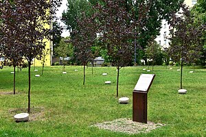
Garden of the Righteous, Warsaw
Memorial site in Poland
Distance: Approx. 327 meters
Latitude and longitude: 52.2458,20.9895
The Garden of the Righteous in Warsaw (Polish: Ogród Sprawiedliwych w Warszawie) is a memorial site in Wola, Muranów. The initiators of the idea are the History Meeting House and the Italian foundation GARIWO. It is a place to honour those who, during the 20th and 21st centuries, in the face of totalitarianism and genocide, had the courage to defend human dignity. Each year, on the European Day of the Righteous (established by the European Parliament in 2012), the Garden Committee, announces the names of those to be honoured with that title.

University of Economics and Human Sciences in Warsaw
Distance: Approx. 188 meters
Latitude and longitude: 52.24416667,20.9825
The University of Economics and Human Sciences in Warsaw (UEHS, Polish: Akademia Ekonomiczno-Humanistyczna w Warszawie; AEH) is a non-public academic higher education institution based in Warsaw, Poland. It was established in 2001 as the University of Finance and Management in Warsaw (UFM, Polish: Wyższa Szkoła Finansów i Zarządzania w Warszawie; WSFiZ). UEHS specializes in the fields of finance and management, social sciences, and human sciences, but also offers degrees in medical sciences and the arts.
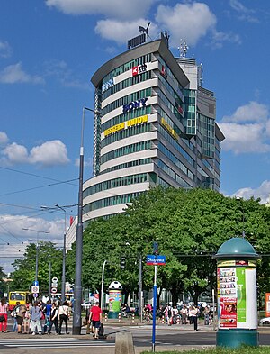
City Gate (Warsaw)
Skyscraper in Warsaw, Poland
Distance: Approx. 271 meters
Latitude and longitude: 52.2425,20.98293333
The City Gate, formerly known as Skwer Wolski (Wola Square), is a skyscraper office building in Warsaw, Poland, located at 58 Ogrodowa Street.
Caritas Poland
Social welfare and humanitarian relief organisation of the Catholic Church in Poland.
Distance: Approx. 613 meters
Latitude and longitude: 52.24776,20.97795
Caritas Poland (Polish: Caritas Polska) is a Polish Catholic not-for-profit social welfare and humanitarian relief organisation. It is a service of the Polish Bishops' Conference and the largest social welfare and charitable organisation in the country. Caritas Poland is a member of both Caritas Europa and Caritas Internationalis.
Weather in this IP's area
scattered clouds
13 Celsius
13 Celsius
12 Celsius
14 Celsius
1028 hPa
75 %
1028 hPa
1015 hPa
10000 meters
6.26 m/s
100 degree
39 %
06:20:46
18:37:25