Country:
 Poland
Region:
City:
Latitude and Longitude:
Time Zone:
Postal Code:
IP information under different IP Channel
ip-api
Country
Region
City
ASN
Time Zone
ISP
Blacklist
Proxy
Latitude
Longitude
Postal
Route
IPinfo
Country
Region
City
ASN
Time Zone
ISP
Blacklist
Proxy
Latitude
Longitude
Postal
Route
MaxMind
Country
Region
City
ASN
Time Zone
ISP
Blacklist
Proxy
Latitude
Longitude
Postal
Route
Luminati
Country
PLRegion
14
City
warsaw
ASN
Time Zone
Europe/Warsaw
ISP
Liberty Global B.V.
Latitude
Longitude
Postal
db-ip
Country
Region
City
ASN
Time Zone
ISP
Blacklist
Proxy
Latitude
Longitude
Postal
Route
ipdata
Country
Region
City
ASN
Time Zone
ISP
Blacklist
Proxy
Latitude
Longitude
Postal
Route
Popular places and events near this IP address

Wierzbno metro station
Warsaw metro station
Distance: Approx. 1171 meters
Latitude and longitude: 52.18972222,21.01666667
Metro Wierzbno is a station on Line M1 of the Warsaw Metro, located in the Wierzbno neighbourhood, from which it derives its name. The station is in the Mokotów district of Warsaw. The station was opened on 7 April 1995 as part of the inaugural stretch of the Warsaw Metro, between Kabaty and Politechnika.

Wilanowska metro station
Warsaw metro station
Distance: Approx. 560 meters
Latitude and longitude: 52.18138889,21.02305556
Metro Wilanowska is a station on Line M1 of the Warsaw Metro, located in the Mokotów district of Warsaw at the junction of Aleja Niepodległości, Puławska Street, and Aleja Wilanowska, all main streets of Warsaw. It is an important transfer point to a large bus station, serving routes through the city and to the surrounding towns and villages. The station was opened on 7 April 1995 as part of the inaugural stretch of the Warsaw Metro, between Kabaty and Politechnika.
Interdisciplinary Centre for Mathematical and Computational Modelling
Supercomputing and research data centre
Distance: Approx. 1133 meters
Latitude and longitude: 52.19222222,21.02194444
Interdisciplinary Centre for Mathematical and Computational Modelling (ICM) is a supercomputing and research data centre at the University of Warsaw in Poland.

Ksawerów, Warsaw
Neighbourhood in Warsaw, Poland
Distance: Approx. 812 meters
Latitude and longitude: 52.18361111,21.01861111
Ksawerów is a neighbourhood, and an area of the City Information System, in the city of Warsaw, Poland, located within the district of Mokotów. The neighbourhood mostly consists of a residential area, consisting of multifamily residential apartment buildings, and single-family detached homes. The year 1456 marks the first known mention in the documentation of the settlement of Szopy, a small which was partially located within the current boundaries of Ksawerów.
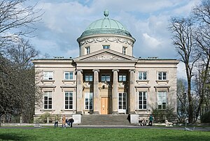
Królikarnia
Building in Warsaw, Poland
Distance: Approx. 628 meters
Latitude and longitude: 52.189,21.02847222
Królikarnia (in English, "The Rabbit House") is a historic classicist palace in Warsaw, Poland; and a neighborhood in the Mokotów district of Warsaw. Since 1965 the palace has housed a museum dedicated to Polish sculptor Xawery Dunikowski.
Museum of the Polish Peasant Movement
History museum in Warsaw, Poland
Distance: Approx. 707 meters
Latitude and longitude: 52.1775,21.03388889
Muzeum Historii Polskiego Ruchu Ludowego is a museum in Warsaw, Poland. It was established in 1984. The museum is located in a building known as the ‘Yellow Tavern’ („Żółta Karczma”).

PolskiBus
Polish express coach operator
Distance: Approx. 642 meters
Latitude and longitude: 52.1836,21.0211
PolskiBus was a Polish express coach operator. Owned by Brian Souter's Highland Global Transport, it commenced operating in June 2011. It was sold to Flixbus in December 2017 with the PolskiBus brand retired in February 2018.

Łazarski University
Distance: Approx. 1211 meters
Latitude and longitude: 52.1775,21.0157
Łazarski University (Polish: Uczelnia Łazarskiego; formerly known as Ryszard Łazarski Higher School of Commerce and Law In Warsaw) is a private Polish university located in Warsaw, founded by Ryszard Łazarski in 1993. The educational offer comprises studies at 3 faculties: the Faculty of Law and Administration, the Faculty of Economics and Management and the Faculty of Medicine. The university’s educational offer comprises BA studies, MA studies, doctoral studies in law, postgradual studies, MBA, LLM, doctoral seminars, trainings and language courses.
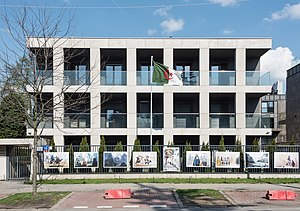
Embassy of Algeria, Warsaw
Diplomatic mission of Algeria in Poland
Distance: Approx. 1031 meters
Latitude and longitude: 52.19103333,21.02171111
The Embassy of Algeria in Warsaw is the diplomatic mission of Algeria in Poland. The embassy is located in the city of Warsaw, Poland, at 10 Krasickiego Street. The current ambassador of Algeria to Poland is Salem Ait Chabane.
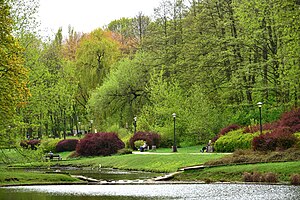
Arcadia Park (Warsaw)
Urban park in Warsaw, Poland
Distance: Approx. 765 meters
Latitude and longitude: 52.19027778,21.02861111
The Arcadia Park is an urban park in Warsaw, Poland. It is located in the district of Mokotów between Puławska Street, Żywnego Street, Piaseczyńska Street, Idzikowskiego Street, and around the gardens of Królikarnia Palace. It was opened in 1970.
Skarpa Puławska
Neighbourhood in Warsaw, Poland
Distance: Approx. 1081 meters
Latitude and longitude: 52.19277778,21.02583333
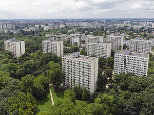
Skarpa Puławska, also known as Skarpa, and Bielawska-Żywnego, is a residential neighbourhood in the city of Warsaw, Poland, in the district of Mokotów, within the City Information System area of Wierzbno. It is located between Puławska Street, Bielawska Street, Żywnego Street, the peaks of Warsaw Escarpment, and around the Warszawianka sports complex. The neighborhood consists of eight 13-storey multifamily residential large panel system-buildings.

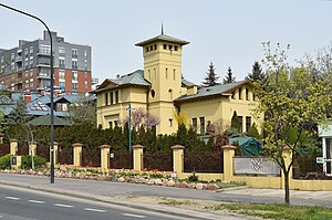
Ksawerów Manor House
Manor house in Warsaw, Poland
Distance: Approx. 772 meters
Latitude and longitude: 52.186624,21.020404
The Ksawerów Manor House (Polish: Dwór Ksawerów) is a neoclassical manor house in Warsaw, Poland, located at 13 Ksawerów Street. The building was designed by Wojciech Bobiński, and constructed in 1840, as the residence for nobleperson Ksawer Pusłowski.
Weather in this IP's area
overcast clouds
20 Celsius
19 Celsius
18 Celsius
21 Celsius
1020 hPa
60 %
1020 hPa
1008 hPa
10000 meters
8.94 m/s
90 degree
90 %
06:12:26
18:49:05