Country:
Region:
City:
Latitude and Longitude:
Time Zone:
Postal Code:
IP information under different IP Channel
ip-api
Country
Region
City
ASN
Time Zone
ISP
Blacklist
Proxy
Latitude
Longitude
Postal
Route
Luminati
Country
Region
14
City
warsaw
ASN
Time Zone
Europe/Warsaw
ISP
Liberty Global B.V.
Latitude
Longitude
Postal
IPinfo
Country
Region
City
ASN
Time Zone
ISP
Blacklist
Proxy
Latitude
Longitude
Postal
Route
db-ip
Country
Region
City
ASN
Time Zone
ISP
Blacklist
Proxy
Latitude
Longitude
Postal
Route
ipdata
Country
Region
City
ASN
Time Zone
ISP
Blacklist
Proxy
Latitude
Longitude
Postal
Route
Popular places and events near this IP address

General Kazimierz Sosnkowski Municipal Stadium
Distance: Approx. 6 meters
Latitude and longitude: 52.25551667,21.00132222
The General Kazimierz Sosnkowski Municipal Stadium (Polish: Stadion Miejski im. gen. Kazimierza Sosnkowskiego) or Polonia Warsaw Stadium (Polish: Stadion Polonii Warszawa), known colloquially as K6, is a multi-purpose stadium in Warsaw, Poland.

Franciszkańska Street, Warsaw
Street in Warsaw, Poland
Distance: Approx. 388 meters
Latitude and longitude: 52.25222222,21.00333333
Franciszkańska (Polish: Franciscan Street) is a street in the centre of Warsaw, linking the New Town with Nalewki street. In the 19th century it was inhabited primarily by Jews, who converted the street into a large open-air marketplace. The name itself was derived from the Church of Saint Francis owned by the Franciscans.

Dworzec Gdański metro station
Warsaw metro station
Distance: Approx. 538 meters
Latitude and longitude: 52.25777778,20.99444444
Dworzec Gdański (Gdańsk Train Station) is a station on Line M1 of the Warsaw Metro, located just south of the Warszawa Gdańska railway station, at the viaduct of Andersa Street over Słomińskiego Street. It is one of the major transport hubs in the northern part of the city of Warsaw. The station was opened on 20 December 2003 as the northern terminus of the extension from Ratusz.
Sapieha Palace, Warsaw
Building in Warsaw, Poland
Distance: Approx. 388 meters
Latitude and longitude: 52.25416667,21.00666667
Sapieha Palace (Polish: pałac Sapiehów w Warszawie) is one of the palaces in Warsaw New Town district of Warsaw, Poland. Started by the powerful Sapieha family who gave the name to the building, it currently houses the Environmental Protection School Complex.
Bonifraterska Street, Warsaw
Street in Warsaw
Distance: Approx. 278 meters
Latitude and longitude: 52.25305556,21.00055556
The Bonifraterska Street (Polish: Ulica Bonifraterska) in Warsaw, Poland, is one of the main streets of Warsaw's New Town, stretching from Długa Street and the Krasiński Palace to Słomiński street. It is one of the most historical of Warsaw's streets.

Intraco
High-Rise in Warsaw, Poland
Distance: Approx. 343 meters
Latitude and longitude: 52.25444444,20.99666667
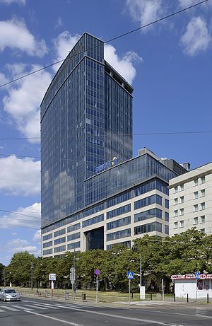
Intraco I is a skyscraper in Warsaw, by Swedish company Byggnadsproduktion AB. The skyscraper is located at Stawki street, at the border of two districts Śródmieście and Żoliborz, close to the Dworzec Gdański metro and train station. The total height of the building, including its antenna is 138 metres. The building has 39 stories with a total area 31500 square metres.

Church of John of God, Warsaw
Church in Warsaw, Poland
Distance: Approx. 218 meters
Latitude and longitude: 52.253611,21.000556
The Church of John of God is a Roman Catholic church belonging to the Brothers Hospitallers of St. John of God (the Bonifratrzy). It is located at 12 Bonifraterska Street in Warsaw.
Monument to the Fallen and Murdered in the East
Monument in Warsaw
Distance: Approx. 258 meters
Latitude and longitude: 52.25376389,20.99888889
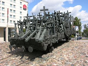
The Monument to the Fallen and Murdered in the East is a monument in Warsaw, Poland which commemorates the victims of the Soviet invasion of Poland during World War II and subsequent repressions. It was unveiled on 17 September 1995, on the 56th anniversary of the Soviet invasion of 1939.
Samborska Street
Street in Warsaw, Poland
Distance: Approx. 473 meters
Latitude and longitude: 52.25506,21.00831
Samborska Street (Polish: ulica Samborska) is the shortest street in Warsaw and possibly in Poland. Approximately 22 metres (72 ft) long, it is located in Warsaw's New Town, just off Przyrynek Street near the Polish Security Printing Works building. It was laid out in 1770 or 1771.

Church of St. Francis, Warsaw
Church in Warsaw, Poland
Distance: Approx. 416 meters
Latitude and longitude: 52.25361111,21.00666667
The Church of St. Francis (Polish: Kościół pw. Stygmatów św.
List of ambassadors of China to Poland
Distance: Approx. 536 meters
Latitude and longitude: 52.250724,21.0024
The Chinese ambassador to Poland is the official representative of the People's Republic of China to the Republic of Poland.

North Gate (Warsaw)
Building in Warsaw, Poland
Distance: Approx. 237 meters
Latitude and longitude: 52.25444444,20.99837778
North Gate (formerly Centrum Belvedere) is a high-rise office building in Warsaw, Poland.
Weather in this IP's area
clear sky
8 Celsius
5 Celsius
8 Celsius
9 Celsius
1025 hPa
46 %
1025 hPa
1013 hPa
10000 meters
7.15 m/s
270 degree
06:35:35
16:03:27


