Country:
Region:
City:
Latitude and Longitude:
Time Zone:
Postal Code:
IP information under different IP Channel
ip-api
Country
Region
City
ASN
Time Zone
ISP
Blacklist
Proxy
Latitude
Longitude
Postal
Route
Luminati
Country
Region
14
City
warsaw
ASN
Time Zone
Europe/Warsaw
ISP
Liberty Global B.V.
Latitude
Longitude
Postal
IPinfo
Country
Region
City
ASN
Time Zone
ISP
Blacklist
Proxy
Latitude
Longitude
Postal
Route
db-ip
Country
Region
City
ASN
Time Zone
ISP
Blacklist
Proxy
Latitude
Longitude
Postal
Route
ipdata
Country
Region
City
ASN
Time Zone
ISP
Blacklist
Proxy
Latitude
Longitude
Postal
Route
Popular places and events near this IP address

Białołęka
Dzielnica of Warsaw in Masovian Voivodeship, Poland
Distance: Approx. 3573 meters
Latitude and longitude: 52.321,20.9705
Białołęka (Polish pronunciation: [bʲawɔˈwɛŋka] , lit. White Meadow) is one of 18 districts of Warsaw, located in the northern part of the city. Until October 27, 2002 Białołęka was a gmina.

Gmina Jabłonna, Masovian Voivodeship
Gmina in Masovian Voivodeship, Poland
Distance: Approx. 3853 meters
Latitude and longitude: 52.37777778,20.91638889
Gmina Jabłonna is a semi-rural gmina (administrative district) in Legionowo County, Masovian Voivodeship, in east-central Poland. Its seat is the village of Jabłonna, which lies approximately 3 kilometres (2 mi) south of Legionowo and 19 km (12 mi) north of Warsaw. The gmina covers an area of 64.55 square kilometres (24.9 sq mi), and as of 2006 its total population is 13,172 (17,531 in 2013).

Jabłonna, Legionowo County
Village in Masovian Voivodeship, Poland
Distance: Approx. 3877 meters
Latitude and longitude: 52.37805556,20.91638889
Jabłonna [jaˈbwɔnna] is a village in Legionowo County, Masovian Voivodeship, in east-central Poland. It is the seat of the Gmina Jabłonna (administrative district). It is located approximately 4 kilometres (2 mi) south of Legionowo and 18 km (11 mi) north of Warsaw.

Łomianki Dolne
Village in Masovian Voivodeship, Poland
Distance: Approx. 3975 meters
Latitude and longitude: 52.36666667,20.9
Łomianki Dolne [wɔˈmjaŋki ˈdɔlnɛ] is a village in the administrative district of Gmina Łomianki, within Warsaw West County, Masovian Voivodeship, in east-central Poland. It lies approximately 4 kilometres (2 mi) north of Łomianki, 18 km (11 mi) north of Ożarów Mazowiecki, and 18 km (11 mi) north of Warsaw.

Jabłonna Palace
Building in Jabłonna, Poland
Distance: Approx. 3704 meters
Latitude and longitude: 52.37472222,20.91416667
Jabłonna Palace (Polish: Pałac w Jabłonnie) is a palace, hotel and publicly accessible park-complex in Jabłonna near Warsaw in Poland whose uses include conferences and weddings.
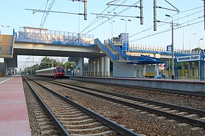
Warszawa Płudy railway station
Railway station in Warsaw, Poland
Distance: Approx. 2857 meters
Latitude and longitude: 52.335,20.98527778
Warszawa Płudy railway station is a railway station in the Białołęka district of Warsaw, Poland. As of 2012, the 2 platform, 2 track station is used by Koleje Mazowieckie, who run the KM9 services from Warszawa Wola or Warszawa Zachodnia through the north of the Masovian Voivodeship to Działdowo, in the Warmian-Masurian Voivodeship via Legionowo, Nasielsk, Modlin, Ciechanów and Mława, at all of which some trains terminate, and by Szybka Kolej Miejska, who run S9 services to Wieliszew, with some trains terminating at Legionowo or Legionowo Piaski.
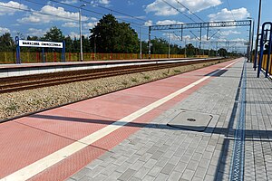
Warszawa Choszczówka railway station
Railway station in Warsaw, Poland
Distance: Approx. 1532 meters
Latitude and longitude: 52.35777778,20.9725
Warszawa Choszczówka railway station is a railway station in the Białołęka district of Warsaw, Poland. As of 2012, it is used by Koleje Mazowieckie, who run the KM9 services from Warszawa Wola or Warszawa Zachodnia through the north of the Masovian Voivodeship to Działdowo, in the Warmian-Masurian Voivodeship via Legionowo, Nasielsk, Modlin, Ciechanów and Mława, at all of which some trains terminate, and by Szybka Kolej Miejska, who run S9 services to Wieliszew, with some trains terminating at Legionowo or Legionowo Piaski.

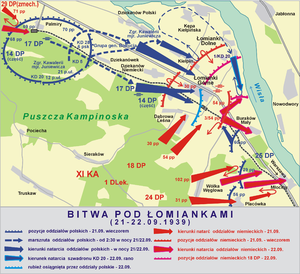
Battle of Łomianki
Distance: Approx. 4268 meters
Latitude and longitude: 52.3357,20.8953
The Battle of Łomianki was a part of the opening campaign of World War II during the 1939 German invasion of Poland, fought between Polish and German forces. It was a failed counter-offensive attempt by the Polish forces.

Tarchomin
Distance: Approx. 3743 meters
Latitude and longitude: 52.31805556,20.96194444
Tarchomin is a neighborhood of Białołęka district, in northern Warsaw, Poland.

Henryków, Białołęka
Distance: Approx. 2357 meters
Latitude and longitude: 52.33222222,20.96805556
Henryków is a neighborhood of the Białołęka district of northern Warsaw, Poland. The estate is located east of Modlińska Street.

Dąbrówka Szlachecka
Neighbourhood of Warsaw, Poland
Distance: Approx. 635 meters
Latitude and longitude: 52.34641944,20.95780556
Dąbrówka Szlachecka is a neighbourhood, and an area of the Municipal Information System, in the city of Warsaw, Poland, located within the district of Białołęka.

Dąbrówka Grzybowska
Neighbourhood of Warsaw, Poland
Distance: Approx. 3502 meters
Latitude and longitude: 52.32916667,20.98944444
Dąbrówka Grzybowska is a neighbourhood in the city of Warsaw, Poland, located within the district of Białołęka, in the Municipal Information System area of Białołęka Dworska.
Weather in this IP's area
light rain
3 Celsius
2 Celsius
3 Celsius
4 Celsius
1032 hPa
84 %
1032 hPa
1022 hPa
10000 meters
1.52 m/s
1.6 m/s
236 degree
9 %
06:37:54
16:01:34

