Country:
Region:
City:
Latitude and Longitude:
Time Zone:
Postal Code:
IP information under different IP Channel
ip-api
Country
Region
City
ASN
Time Zone
ISP
Blacklist
Proxy
Latitude
Longitude
Postal
Route
Luminati
Country
ASN
Time Zone
Europe/Berlin
ISP
meerfarbig GmbH & Co. KG
Latitude
Longitude
Postal
IPinfo
Country
Region
City
ASN
Time Zone
ISP
Blacklist
Proxy
Latitude
Longitude
Postal
Route
db-ip
Country
Region
City
ASN
Time Zone
ISP
Blacklist
Proxy
Latitude
Longitude
Postal
Route
ipdata
Country
Region
City
ASN
Time Zone
ISP
Blacklist
Proxy
Latitude
Longitude
Postal
Route
Popular places and events near this IP address

Riederwald
Quarter of Frankfurt am Main in Germany
Distance: Approx. 1259 meters
Latitude and longitude: 50.13,8.73361111
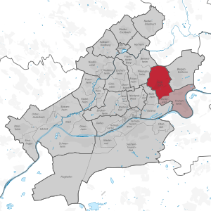
Riederwald is a quarter of Frankfurt am Main, Germany. It is part of the Ortsbezirk Ost. Riederwald is one of the smallest districts in Frankfurt.

Seckbach (Frankfurt am Main)
Quarter of Frankfurt am Main in Hesse, Germany
Distance: Approx. 1276 meters
Latitude and longitude: 50.14472222,8.72694444
Seckbach is a quarter of Frankfurt am Main, Germany. It is part of the Ortsbezirk Ost.

Battle of Bergen (1759)
1759 battle in the Seven Years' War
Distance: Approx. 1860 meters
Latitude and longitude: 50.155,8.75305556
The Battle of Bergen on 13 April 1759 saw the French army under de Broglie withstand an allied British, Hanoverian, Hessian, Brunswick army under Prince Ferdinand of Brunswick near Frankfurt-am-Main during the Seven Years' War.

Bergen, Hesse
Village of Frankfurt in Hesse, Germany
Distance: Approx. 1777 meters
Latitude and longitude: 50.155,8.7495
Bergen is a former municipality in Hesse, Germany. Presently, it is part of Bergen-Enkheim, a borough of Frankfurt. It was the location of the Battle of Bergen (Seven Years' War).

Eissporthalle Frankfurt
Indoor ice hockey venue in Germany
Distance: Approx. 2215 meters
Latitude and longitude: 50.12527778,8.72138889
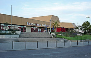
Eissporthalle Frankfurt or Eissporthalle am Ratsweg is an arena in the Bornheim district of Frankfurt, Germany. It is used for ice hockey and is the home arena of Löwen Frankfurt. It is also used as an ice skating rink.

PSD Bank Arena
Multi-use stadium in Frankfurt am Main, Hesse, Germany
Distance: Approx. 1900 meters
Latitude and longitude: 50.12805556,8.72333333
The PSD Bank Arena (formerly known as Stadion am Bornheimer Hang) is a multi-use stadium in Bornheim, a district of Frankfurt am Main, Germany, and is best accessed by the Johanna-Tesch-Platz U-Bahn station (which is located on territory of the district Riederwald), or (for away fans) the Eissporthalle/Festplatz station. It is currently used mostly for football matches and is the home stadium of FSV Frankfurt and occasionally used to host 1. FFC Frankfurt (now Eintracht Frankfurt).

Riederwaldstadion
Football stadium in Frankfurt, Germany
Distance: Approx. 1161 meters
Latitude and longitude: 50.13305556,8.73027778
Riederwaldstadion is a stadium in Seckbach district of Frankfurt am Main in Germany. It was home pitch for Eintracht Frankfurt U23 until 2008, when Eintracht Frankfurt U23 moved. The stadium was destroyed during World War II in 1943 and was rebuilt in 1952.

Bergen-Enkheim
Borough of Frankfurt am Main in Hesse, Germany
Distance: Approx. 1860 meters
Latitude and longitude: 50.155,8.75305556
Bergen-Enkheim is a borough (Ortsbezirk) of Frankfurt am Main, Germany. Bergen-Enkheim is a popular residential area with families and sports enthusiasts for its small-town character, excellent infrastructure, and the highest number of clubs (Vereine) in Frankfurt, many of them sports clubs. Its athletic facilities include a modern track and field complex, a tennis club, an extensive, recently modernized indoor and outdoor public swimming and sports center, and a nature preserve with small lakes and many kilometers of forested walking, running and biking paths (Enkheimer Ried).
Frankfurt-Mainkur station
Railway station in Frankfurt, Germany
Distance: Approx. 1835 meters
Latitude and longitude: 50.13416667,8.76722222
Frankfurt-Mainkur station is located on the Frankfurt Süd–Aschaffenburg railway between Frankfurt East station and Hanau Hauptbahnhof in the Frankfurt district of Fechenheim in the German state of Hesse. The station is classified by Deutsche Bahn (DB) as a category 5 station.

Batschkapp
Rock and pop concert venue in Frankfurt am Main
Distance: Approx. 548 meters
Latitude and longitude: 50.1353,8.7392
Batschkapp (Hessian dialect for 'flat cap') is a rock and pop concert venue in Frankfurt am Main. It is located in the warehouse district of the neighborhood of Seckbach, on Gwinnerstraße.
Maria Rosenkranz, Frankfurt
Church in Hesse, Germany
Distance: Approx. 1533 meters
Latitude and longitude: 50.1412,8.7216
Maria Rosenkranz (Mary Rosary) is a Catholic church in Frankfurt-Seckbach, part of Frankfurt am Main. It was completed in 1953. On 1 January 2015 the parish became a Kirchort (church location), part of the parish St.

Heilig Geist, Frankfurt
Church in Frankfurt am Main, Germany
Distance: Approx. 1319 meters
Latitude and longitude: 50.12916667,8.73416667
Heilig Geist (Holy Spirit) is the name of a Catholic church in the suburb Riederwald of Frankfurt am Main, Hesse, Germany. The parish church of the Riederwald congregation is part of the Roman Catholic Diocese of Limburg. On 1 January 2015 the parish became a Kirchort (church location), part of the parish St.
Weather in this IP's area
clear sky
12 Celsius
11 Celsius
11 Celsius
13 Celsius
1029 hPa
76 %
1029 hPa
1016 hPa
10000 meters
3.09 m/s
80 degree
07:18:47
16:58:19

