178.22.18.61 - IP Lookup: Free IP Address Lookup, Postal Code Lookup, IP Location Lookup, IP ASN, Public IP
Country:
Region:
City:
Location:
Time Zone:
Postal Code:
ISP:
ASN:
language:
User-Agent:
Proxy IP:
Blacklist:
IP information under different IP Channel
ip-api
Country
Region
City
ASN
Time Zone
ISP
Blacklist
Proxy
Latitude
Longitude
Postal
Route
db-ip
Country
Region
City
ASN
Time Zone
ISP
Blacklist
Proxy
Latitude
Longitude
Postal
Route
IPinfo
Country
Region
City
ASN
Time Zone
ISP
Blacklist
Proxy
Latitude
Longitude
Postal
Route
IP2Location
178.22.18.61Country
Region
uusimaa
City
mantsala
Time Zone
Europe/Helsinki
ISP
Language
User-Agent
Latitude
Longitude
Postal
ipdata
Country
Region
City
ASN
Time Zone
ISP
Blacklist
Proxy
Latitude
Longitude
Postal
Route
Popular places and events near this IP address

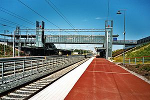
Mäntsälä railway station
Railway station in Mäntsälä, Finland
Distance: Approx. 1659 meters
Latitude and longitude: 60.6475,25.3075
Mäntsälä railway station (Finnish: Mäntsälän rautatieasema, Swedish: Mäntsälä järnvägsstation) is located in the town of Mäntsälä, Finland, approximately 60 kilometres (40 mi) from Helsinki Central railway station. The station was opened on 3 September 2006 as part of the new Kerava-Lahti railway line, and is served by the Z-trains which run on this route.

Mäntsälä (village)
Municipal center in Uusimaa, Finland
Distance: Approx. 154 meters
Latitude and longitude: 60.63333333,25.31388889
Mäntsälän kirkonkylä (lit. 'Mäntsälä church village') is the largest urban area and the municipal center of Mäntsälä in Uusimaa, Finland, with about 11,000 inhabitants. It is located 24 kilometres (15 mi) from Järvenpää, 28 kilometres (17 mi) from Hyvinkää, 38 kilometres (24 mi) from Porvoo and 43 kilometres (27 mi) from Lahti. The Mäntsälänjoki River flows through the area and joins the Mustijoki River further south, which runs all the way to the Gulf of Finland.

Sälinkää
Village in Uusimaa, Finland
Distance: Approx. 9894 meters
Latitude and longitude: 60.71166667,25.23111111
Sälinkää (Finnish: [ˈsæliŋkæː]; Swedish: Sellinge, Finland Swedish: [ˈselːiŋe]) is a village in the Mäntsälä municipality in Uusimaa, Finland, with over 200 inhabitants. It is located 11 kilometres (6.8 mi) northwest of the Mäntsälä's municipal centre and 17 kilometres (11 mi) southeast of Oitti, the municipal centre of Hausjärvi. The north-south road 1471 from Hausjärvi to Mäntsälä passes through the village.

Numminen, Mäntsälä
Village in Finland
Distance: Approx. 8391 meters
Latitude and longitude: 60.55972222,25.28333333
Numminen is a village in the southern part of the Mäntsälä municipality near the border of Pornainen in Uusimaa, Finland. More than 300 inhabitants live in the village. It is located along the Mustijoki River, about 10 kilometres (6.2 mi) south of the Mäntsälä's municipal centre and about 12 kilometres (7.5 mi) northwest of Kirveskoski, the municipal centre of Pornainen.
Weather in this IP's area
broken clouds
0 Celsius
0 Celsius
0 Celsius
0 Celsius
1023 hPa
95 %
1023 hPa
1014 hPa
10000 meters
0.97 m/s
1.46 m/s
200 degree
54 %