178.21.2.67 - IP Lookup: Free IP Address Lookup, Postal Code Lookup, IP Location Lookup, IP ASN, Public IP
Country:
Region:
City:
Location:
Time Zone:
Postal Code:
ISP:
ASN:
language:
User-Agent:
Proxy IP:
Blacklist:
IP information under different IP Channel
ip-api
Country
Region
City
ASN
Time Zone
ISP
Blacklist
Proxy
Latitude
Longitude
Postal
Route
db-ip
Country
Region
City
ASN
Time Zone
ISP
Blacklist
Proxy
Latitude
Longitude
Postal
Route
IPinfo
Country
Region
City
ASN
Time Zone
ISP
Blacklist
Proxy
Latitude
Longitude
Postal
Route
IP2Location
178.21.2.67Country
Region
thuringen
City
martinroda
Time Zone
Europe/Berlin
ISP
Language
User-Agent
Latitude
Longitude
Postal
ipdata
Country
Region
City
ASN
Time Zone
ISP
Blacklist
Proxy
Latitude
Longitude
Postal
Route
Popular places and events near this IP address

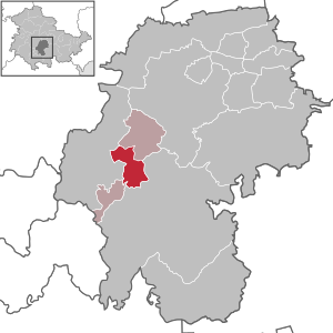
Martinroda, Ilm-Kreis
Municipality in Thuringia, Germany
Distance: Approx. 976 meters
Latitude and longitude: 50.725,10.88777778
Martinroda is a municipality in the district Ilm-Kreis, in Thuringia, Germany. The former municipality Angelroda was merged into Martinroda in December 2019.
Angelroda
Ortsteil of Martinroda in Thuringia, Germany
Distance: Approx. 3312 meters
Latitude and longitude: 50.74472222,10.8675
Angelroda is a village and a former municipality in the district Ilm-Kreis, in Thuringia, Germany founded in 958. Since December 2019, it is part of the municipality Martinroda.
Elgersburg
Municipality in Thuringia, Germany
Distance: Approx. 2498 meters
Latitude and longitude: 50.70444444,10.85361111
Elgersburg is a municipality situated in the district of Ilm-Kreis, Thuringia, Germany.
Geraberg
Ortsteil of Geratal in Thuringia, Germany
Distance: Approx. 2645 meters
Latitude and longitude: 50.71805556,10.84583333
Geraberg is a village and a former municipality located at the northern edge of the Thuringian Forest in the district Ilm-Kreis, in Thuringia, Germany. Since 1 January 2019, it is part of the municipality Geratal.
Neusiß
Ortsteil of Plaue in Thuringia, Germany
Distance: Approx. 3230 meters
Latitude and longitude: 50.74555556,10.88805556
Neusiß is a village and a former municipality in the district Ilm-Kreis, in Thuringia, Germany. Since 1 January 2019, it is part of the town Plaue.
Geratal/Plaue
Distance: Approx. 1554 meters
Latitude and longitude: 50.73,10.89
Geratal/Plaue (before 2019: Geratal) is a Verwaltungsgemeinschaft ("collective municipality") in the district Ilm-Kreis, in Thuringia, Germany. The seat of the Verwaltungsgemeinschaft is in Geraberg, itself not part of the Verwaltungsgemeinschaft.
Gabelbach (Ilm)
River in Thuringia, Germany
Distance: Approx. 4331 meters
Latitude and longitude: 50.68166667,10.91
Gabelbach is a small river of Thuringia, Germany. It joins the Ilm in Ilmenau.
Körnbach
River in Thuringia, Germany
Distance: Approx. 2759 meters
Latitude and longitude: 50.7178,10.8442
Körnbach is a river of Thuringia, Germany. It flows into the Zahme Gera in Geraberg.
Wirrbach
River in Thuringia, Germany
Distance: Approx. 3290 meters
Latitude and longitude: 50.7443,10.8666
Wirrbach is a river of Thuringia, Germany. It flows into the Zahme Gera in Angelroda.
Gehrener Formation
Geologic formation in Germany
Distance: Approx. 2200 meters
Latitude and longitude: 50.7,10.9
The Gehrener Schichten (German for Gehren Formation) is a geologic formation in Germany. The fluvial to lacustrine shales preserve fossils dating back to the Late Carboniferous period (Stephanian C in European stratigraphy or Gzhelian in international stratigraphy).
Wirrbachtalbrücke
Arch bridge in Germany
Distance: Approx. 4020 meters
Latitude and longitude: 50.7367,10.8358
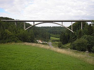
The Wirrbachtalbrücke is an arch bridge in Geschwenda, Thuringia, Germany. The bridge is located on the Bundesstraße 88 (Ohrdruf–Ilmenau), above the Wirrbach river of the Thuringian Forest. It is 235 metres (771 ft) long and 40 metres (130 ft) in height.
St.-Jakobus-Kirche, Ilmenau
Church in Thuringia, Germany
Distance: Approx. 4136 meters
Latitude and longitude: 50.68555556,10.91527778
The St.-Jakobus-Kirche (pronounced [zaŋkt jaˈkoːbʊsˌkɪʁçə], "St James Church") in the historical centre of Ilmenau, Thuringia, Germany, is a Lutheran parish church. The Ilmenau parish belongs to the Arnstadt-Ilmenau district of the Protestant Church in Central Germany. Colloquially, the St.-Jakobus-Kirche is called the Stadtkirche ("Town Church") for short.
Weather in this IP's area
clear sky
6 Celsius
5 Celsius
6 Celsius
6 Celsius
1032 hPa
53 %
1032 hPa
967 hPa
10000 meters
1.53 m/s
2.14 m/s
64 degree
1 %


