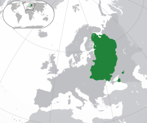
Country:
 Ukraine
Region:
City:
Latitude and Longitude:
Time Zone:
Postal Code:
IP information under different IP Channel
ip-api
Country
Region
City
ASN
Time Zone
ISP
Blacklist
Proxy
Latitude
Longitude
Postal
Route
IPinfo
Country
Region
City
ASN
Time Zone
ISP
Blacklist
Proxy
Latitude
Longitude
Postal
Route
MaxMind
Country
Region
City
ASN
Time Zone
ISP
Blacklist
Proxy
Latitude
Longitude
Postal
Route
Luminati
Country
UAASN
Time Zone
Europe/Kyiv
ISP
LLC ott Ukraine
Latitude
Longitude
Postal
db-ip
Country
Region
City
ASN
Time Zone
ISP
Blacklist
Proxy
Latitude
Longitude
Postal
Route
ipdata
Country
Region
City
ASN
Time Zone
ISP
Blacklist
Proxy
Latitude
Longitude
Postal
Route
Popular places and events near this IP address

Kyiv
Capital of Ukraine
Distance: Approx. 94 meters
Latitude and longitude: 50.45,30.52333333
Kyiv (also Kiev) is the capital and most populous city of Ukraine. It is in north-central Ukraine along the Dnieper River. As of 1 January 2022, its population was 2,952,301, making Kyiv the seventh-most populous city in Europe.
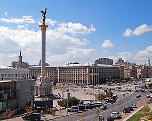
Maidan Nezalezhnosti
Central Square in Kyiv, Ukraine
Distance: Approx. 50 meters
Latitude and longitude: 50.45,30.52416667
Maidan Nezalezhnosti (Ukrainian: Майдан Незалежності [mɐjˈdɑn nezɐˈlɛʒnosʲtʲi], lit. 'Independence Square') is the central square of Kyiv, the capital city of Ukraine. One of the city's main squares, it is located on Khreshchatyk Street in the Shevchenko Raion. The square has been known under many different names, but often it is called by people simply Maidan ("square").
Siege of Kiev (968)
Distance: Approx. 77 meters
Latitude and longitude: 50.45,30.52361111
The siege of Kiev by the Pechenegs in 968 (sub anno 6476) is narrated in pages 65.19–67.20 of the Primary Chronicle, its an account that freely mixes historical details with folklore. Sviatoslav ultimately repelled the Pecheneg invasion and the Siege was a failure for the Pechenegs.

Dniprovskyi District, Kyiv
Urban district in Kyiv in Kyiv Municipality, Ukraine
Distance: Approx. 94 meters
Latitude and longitude: 50.45,30.52333333
The Dniprovskyi District (Ukrainian: Дніпровський район, romanized: Dniprovskyi raion) is an urban district of the city of Kyiv, the capital of Ukraine. It is named after the Dnipro River and is located on its left-bank.

Maidan Nezalezhnosti (Kyiv Metro)
Kyiv Metro Station
Distance: Approx. 45 meters
Latitude and longitude: 50.45,30.52444444
Maidan Nezalezhnosti (Ukrainian: Майдан Незалежності, ) is a station on Kyiv Metro's Obolonsko–Teremkivska line. The station was opened on 17 December 1976, and is named after Kyiv's Maidan Nezalezhnosti (Independence Square) on the Khreshchatyk street. It was designed by N. Kolomiiets, I. Maslenkov, M. Syrkyn, and F. Zaremba.

Kyiv City Duma building
Destroyed building in Kyiv, Ukraine
Distance: Approx. 50 meters
Latitude and longitude: 50.45,30.52416667
The Kyiv City Duma building (Ukrainian: Будинок Київської думи) housed the Kyiv City Duma before World War II. The building was located on the then Dumskaya Ploschad (now Maidan Nezalezhnosti) of the Khreschatyk street in Kyiv and stood in the centre of it.

Kiev Governorate
1802–1925 unit of Russia
Distance: Approx. 78 meters
Latitude and longitude: 50.45,30.5236
Kiev Governorate was an administrative-territorial unit (guberniya) of the Russian Empire from 1796 to 1919 and the Ukrainian Soviet Socialist Republic from 1919 to 1925. It included the territory of the right-bank Ukraine and was formed after a division of the Kiev Viceroyalty into Kiev and Little Russia Governorates in 1796. Its capital was in Kiev.
Kievan Rus'
State in Europe, c. 880 to 1240
Distance: Approx. 57 meters
Latitude and longitude: 50.45,30.525
Kievan Rus', also known as Kyivan Rus', was the first East Slavic state and later an amalgam of principalities in Eastern Europe from the late 9th to the mid-13th century. Encompassing a variety of polities and peoples, including East Slavic, Norse, and Finnic, it was ruled by the Rurik dynasty, founded by the Varangian prince Rurik. The name was coined by Russian historians in the 19th century to describe the period when Kiev was at the center.

Siege of Kiev (1240)
Mongol siege of a Rus' city
Distance: Approx. 77 meters
Latitude and longitude: 50.45,30.52361111
The siege of Kiev by the Mongols took place between 28 November and 6 December 1240, and resulted in a Mongol victory. It was a heavy morale and military blow to the Principality of Galicia–Volhynia, which was forced to submit to Mongol suzerainty, and allowed Batu Khan to proceed westward into Central Europe.

Viche Maidan, Ivano-Frankivsk
City square in Ivano-Frankivsk, Ukraine
Distance: Approx. 50 meters
Latitude and longitude: 50.45,30.52416667
Viche Maidan (Ukrainian: Вічевий майдан) is a city square located in the center of Ivano-Frankivsk.

Embassy of Pakistan, Kyiv
Diplomatic mission of Pakistan in Ukraine
Distance: Approx. 77 meters
Latitude and longitude: 50.45,30.52361111
The Embassy of the Islamic Republic of Pakistan in Kyiv is the diplomatic mission of Pakistan in Ukraine.

Trade Unions Building (Kyiv)
Office building in Kyiv, Ukraine
Distance: Approx. 45 meters
Latitude and longitude: 50.4508,30.5245
The Trade Unions Building, or Budynok Profspilok (officially in Ukrainian: Будинок спілок Федерації професійних спілок України, Union house of the Federation of Trade Unions of Ukraine), is a large office building in Kyiv, Ukraine. Located on the city's main Khreshchatyk Street, its façade faces the central Maidan Nezalezhnosti square and contains the city's main clock tower. The building was built in place of the Noble Assembly building that stood in its place during 1851–1976 and even survived World War II. It was burned down on February 18, 2014 during the Revolution of Dignity.
Weather in this IP's area
clear sky
27 Celsius
26 Celsius
23 Celsius
27 Celsius
1022 hPa
30 %
1022 hPa
1004 hPa
10000 meters
0.89 m/s
2.24 m/s
349 degree
06:23:20
19:28:04