Country:
 Slovakia
Region:
City:
Latitude and Longitude:
Time Zone:
Postal Code:
IP information under different IP Channel
ip-api
Country
Region
City
ASN
Time Zone
ISP
Blacklist
Proxy
Latitude
Longitude
Postal
Route
IPinfo
Country
Region
City
ASN
Time Zone
ISP
Blacklist
Proxy
Latitude
Longitude
Postal
Route
MaxMind
Country
Region
City
ASN
Time Zone
ISP
Blacklist
Proxy
Latitude
Longitude
Postal
Route
Luminati
Country
SKRegion
pv
City
svidnik
ASN
Time Zone
Europe/Bratislava
ISP
PRESNET s.r.o.
Latitude
Longitude
Postal
db-ip
Country
Region
City
ASN
Time Zone
ISP
Blacklist
Proxy
Latitude
Longitude
Postal
Route
ipdata
Country
Region
City
ASN
Time Zone
ISP
Blacklist
Proxy
Latitude
Longitude
Postal
Route
Popular places and events near this IP address

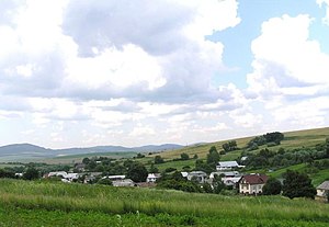
Svidník
Town in Slovakia
Distance: Approx. 719 meters
Latitude and longitude: 49.30555556,21.56777778
Svidník (Hungarian: Felsővízköz, German: Oberswidnik, Rusyn: Свідник, Ukrainian: Свидник) is a town in eastern Slovakia, the capital of the Svidník District in the Prešov Region. It has a population of around 11,000. There is a monumental Soviet Army Memorial in the city, in memory of Battle of the Dukla Pass.
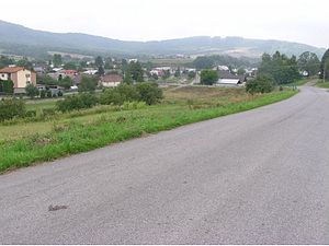
Svidník District
District in Prešov Region, Slovakia
Distance: Approx. 649 meters
Latitude and longitude: 49.30611111,21.56833333
Svidník District (okres Svidník) is a district in the Prešov Region of eastern Slovakia. Until 1918, the district was part of the Hungarian county of Šariš (Sáros).

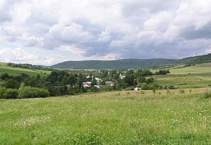
Ladomirová
Municipality in Slovakia
Distance: Approx. 3982 meters
Latitude and longitude: 49.333,21.617
Ladomirová (Hungarian: Ladomérvágása; Rusyn: Ладомирова) is a village and municipality in Svidník District in the Prešov Region of north-eastern Slovakia. The Church of Saint Michael the Archangel of Ladomirová, a wooden Greek Catholic church built in 1742, is part of the Carpathian Wooden Churches UNESCO World Heritage Site. In historical records the village was first mentioned in 1414.
Vagrinec
Municipality in Slovakia
Distance: Approx. 4270 meters
Latitude and longitude: 49.31666667,21.63333333
Vagrinec (Hungarian: Felsővargony, until 1899: Vagrinyecz) is a village and municipality in Svidník District in the Prešov Region of north-eastern Slovakia.

Nová Polianka
Municipality in Slovakia
Distance: Approx. 4181 meters
Latitude and longitude: 49.28333333,21.61666667
Nová Polianka (Rusyn: Нова Полянка; Hungarian: Mérgesvágása, until 1899: Mergeska) is a village and municipality in Svidník District in the Prešov Region of north-eastern Slovakia.
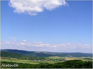
Hrabovčík
Municipality in Slovakia
Distance: Approx. 2993 meters
Latitude and longitude: 49.28333333,21.56666667
Hrabovčík (Hungarian: Gyertyánpatak, until 1899: Hrabovcsik; Rusyn: Грабівчік) is a village and municipality in Svidník District in the Prešov Region of north-eastern Slovakia.

Jurkova Voľa
Municipality in Prešov, Slovakia
Distance: Approx. 4342 meters
Latitude and longitude: 49.31666667,21.51666667
Jurkova Voľa (Rusyn: Юркова Воля; Hungarian: Györgyfölde, until 1899: Jurko-Volya) is a village and municipality in the Svidník District in the Prešov Region of north-eastern Slovakia.

Kapišová
Municipality in Slovakia
Distance: Approx. 3184 meters
Latitude and longitude: 49.33333333,21.6
Kapišová (Rusyn: Капішова; Hungarian: Kapisó) is a village and municipality in Svidník District in the Prešov Region of north-eastern Slovakia.
Kružlová
Municipality in Slovakia
Distance: Approx. 4533 meters
Latitude and longitude: 49.35,21.58333333
Kružlová (Hungarian: Ruzsoly, until 1899: Kruzslyova; Rusyn: Кружльова) is a village and municipality in Svidník District in the Prešov Region of north-eastern Slovakia.
Nižná Jedľová
Municipality in Slovakia
Distance: Approx. 3426 meters
Latitude and longitude: 49.33805556,21.5575
Nižná Jedľová (Rusyn: Нижня Ядлова; Hungarian: Alsófenyves, until 1899: Alsó-Jedlova) is a village and municipality in Svidník District in the Prešov Region of north-eastern Slovakia.

Nižný Orlík
Municipality in Slovakia
Distance: Approx. 4042 meters
Latitude and longitude: 49.33333333,21.53333333
Nižný Orlík (Rusyn: Нижнїй Верліх; Hungarian: Alsóodor) is a village and municipality in Svidník District in the Prešov Region of north-eastern Slovakia.

Stročín
Municipality in Slovakia
Distance: Approx. 5100 meters
Latitude and longitude: 49.26666667,21.6
Stročín (Hungarian: Szorocsány, until 1899: Sztrocsin) is a village and municipality in Svidník District in the Prešov Region of north-eastern Slovakia.
Weather in this IP's area
scattered clouds
16 Celsius
15 Celsius
16 Celsius
18 Celsius
1013 hPa
64 %
1013 hPa
986 hPa
10000 meters
3.86 m/s
7.19 m/s
196 degree
44 %
06:42:33
18:00:04