Country:
 Slovakia
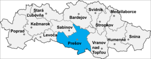
Region:
City:
Latitude and Longitude:
Time Zone:
Postal Code:
IP information under different IP Channel
ip-api
Country
Region
City
ASN
Time Zone
ISP
Blacklist
Proxy
Latitude
Longitude
Postal
Route
IPinfo
Country
Region
City
ASN
Time Zone
ISP
Blacklist
Proxy
Latitude
Longitude
Postal
Route
MaxMind
Country
Region
City
ASN
Time Zone
ISP
Blacklist
Proxy
Latitude
Longitude
Postal
Route
Luminati
Country
SKRegion
pv
City
dulovaves
ASN
Time Zone
Europe/Bratislava
ISP
PRESNET s.r.o.
Latitude
Longitude
Postal
db-ip
Country
Region
City
ASN
Time Zone
ISP
Blacklist
Proxy
Latitude
Longitude
Postal
Route
ipdata
Country
Region
City
ASN
Time Zone
ISP
Blacklist
Proxy
Latitude
Longitude
Postal
Route
Popular places and events near this IP address

Abranovce
Municipality in Prešov Region, Slovakia
Distance: Approx. 4058 meters
Latitude and longitude: 48.93333333,21.35
Abranovce (Hungarian: Ábrány, Rusyn: Абрановце) is a village and municipality in Prešov District in the Prešov Region of eastern Slovakia. The municipality lies at an altitude of 492 metres and covers an area of 9.58 km2 (3.70 sq mi) (2020-06-30/-07-01).
Dulova Ves
Village and municipality in Slovakia
Distance: Approx. 709 meters
Latitude and longitude: 48.95,21.3
Dulova Ves (Hungarian: Sósgyülvész) is a village and municipality in Prešov District in the Prešov Region of eastern Slovakia.
Kendice
Village and municipality in Prešov District in Slovakia
Distance: Approx. 5910 meters
Latitude and longitude: 48.91666667,21.25
Kendice (Hungarian: Kende) is a village and municipality in Prešov District in the Prešov Region of eastern Slovakia.
Kokošovce
Village and municipality in Slovakia
Distance: Approx. 2108 meters
Latitude and longitude: 48.95,21.33333333
Kokošovce (Hungarian: Delnekakasfalva) is a village and municipality in Prešov District in the Prešov Region of eastern Slovakia.
Petrovany
Village and municipality in Slovakia
Distance: Approx. 5148 meters
Latitude and longitude: 48.91666667,21.26666667
Petrovany (Hungarian: Tarcaszentpéter) is a village and municipality in Prešov District in the Prešov Region of eastern Slovakia.

Ruská Nová Ves
Village in Slovakia
Distance: Approx. 3730 meters
Latitude and longitude: 48.98333333,21.33333333
Ruská Nová Ves (Hungarian: Sósújfalu) is a village and municipality in Prešov District in the Prešov Region of eastern Slovakia.
Teriakovce
Village and municipality in Slovakia
Distance: Approx. 3235 meters
Latitude and longitude: 48.98333333,21.31666667
Teriakovce (Hungarian: Terjékfalva) is a village and municipality in Prešov District in the Prešov Region of eastern Slovakia. The village was first mentioned in the historical records in 1385.
Záborské
Distance: Approx. 709 meters
Latitude and longitude: 48.95,21.3
Záborské (Hungarian: Harság) is a village and municipality in Prešov District in the Prešov Region of eastern Slovakia.
Žehňa
Distance: Approx. 5380 meters
Latitude and longitude: 48.91666667,21.35
Žehňa (Hungarian: Zsegnye) is a village and municipality in Prešov District in the Prešov Region of eastern Slovakia.
Haniska, Prešov District
Village and municipality in Slovakia
Distance: Approx. 4824 meters
Latitude and longitude: 48.95777778,21.23972222
Haniska (Hungarian: Eperjesenyicke) is a village and municipality in the Prešov District, Prešov Region in eastern Slovakia.

City Hall Prešov
Distance: Approx. 6142 meters
Latitude and longitude: 48.98577,21.23562806
Tatran Handball Arena, is an indoor sporting arena located in Prešov, Slovakia. The seating capacity of the arena is for 3,870 people. It is currently home to HT Tatran Prešov.
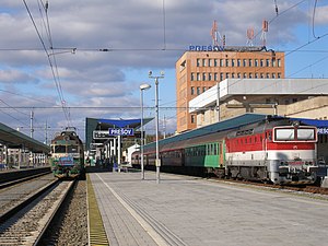
Prešov railway station
Railway station in Prešov, Slovakia
Distance: Approx. 5149 meters
Latitude and longitude: 48.98361111,21.25
Prešov railway station (Slovak Železničná stanica Prešov) is a railway station in the city of Prešov in Prešov Region, third biggest city in Slovakia.
Weather in this IP's area
scattered clouds
15 Celsius
14 Celsius
14 Celsius
15 Celsius
1013 hPa
64 %
1013 hPa
976 hPa
10000 meters
2.97 m/s
5.9 m/s
198 degree
26 %
06:43:20
18:01:27