Country:
 Switzerland
Region:
City:
Latitude and Longitude:
Time Zone:
Postal Code:
IP information under different IP Channel
ip-api
Country
Region
City
ASN
Time Zone
ISP
Blacklist
Proxy
Latitude
Longitude
Postal
Route
IPinfo
Country
Region
City
ASN
Time Zone
ISP
Blacklist
Proxy
Latitude
Longitude
Postal
Route
MaxMind
Country
Region
City
ASN
Time Zone
ISP
Blacklist
Proxy
Latitude
Longitude
Postal
Route
Luminati
Country
CHRegion
zh
City
winterthur
ASN
Time Zone
Europe/Zurich
ISP
Bluewin
Latitude
Longitude
Postal
db-ip
Country
Region
City
ASN
Time Zone
ISP
Blacklist
Proxy
Latitude
Longitude
Postal
Route
ipdata
Country
Region
City
ASN
Time Zone
ISP
Blacklist
Proxy
Latitude
Longitude
Postal
Route
Popular places and events near this IP address

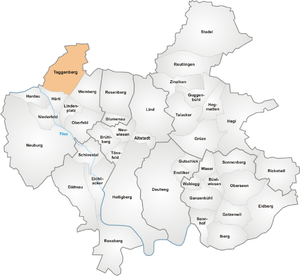
Wülflingen
District in Zürich, Switzerland
Distance: Approx. 278 meters
Latitude and longitude: 47.51,8.683
Wülflingen is a district in the Swiss city of Winterthur, situated in the lower Töss Valley. It is district number six, and comprises the quarters Weinberg, Oberfeld, Lindenplatz, Niederfeld, Neuburg, Hardau, Härti and Taggenberg. Wülflingen was formerly a municipality of its own, but was incorporated into Winterthur in 1922.

Hardau (Winterthur)
Distance: Approx. 740 meters
Latitude and longitude: 47.51388889,8.68027778
Hardau is a quarter in the district 6 of Winterthur. It was formerly a part of Wülflingen municipality, which was incorporated into Winterthur in 1922.

Schlosstal
Distance: Approx. 179 meters
Latitude and longitude: 47.50638889,8.68472222
Schlosstal is a quarter in the district 4 of Winterthur. It was formerly a part of Töss municipality, which was incorporated into Winterthur in 1922.

Oberfeld (Winterthur)
Location within Zürich, Switzerland
Distance: Approx. 1430 meters
Latitude and longitude: 47.508,8.702
Oberfeld is a quarter in the district 6 of Winterthur. Zürich, Switzerland. It was formerly a part of Wülflingen municipality, which was incorporated into Winterthur in 1922.

Lindenplatz
Distance: Approx. 912 meters
Latitude and longitude: 47.51111111,8.69388889
Lindenplatz is a quarter in the district 6 of Winterthur. It was formerly a part of Wülflingen municipality, which was incorporated into Winterthur in 1922.

Niederfeld (Winterthur)
Distance: Approx. 568 meters
Latitude and longitude: 47.51055556,8.67694444
Niederfeld is a quarter in the district 6 of Winterthur. It was formerly a part of Wülflingen municipality, which was incorporated into Winterthur in 1922.

Neuburg (Winterthur)
Distance: Approx. 1304 meters
Latitude and longitude: 47.49666667,8.67638889
Neuburg is a quarter in the district 6 of Winterthur, Switzerland. It was formerly a part of Wülflingen municipality, which was incorporated into Winterthur in 1922. The name of the quarter comes from a former castle called "Neuburg" (engl.

Härti
Distance: Approx. 818 meters
Latitude and longitude: 47.51472222,8.685
Härti is a quarter in the district 6 of Winterthur, in the canton of Zurich in northern Switzerland. It was formerly a part of Wülflingen municipality, which was incorporated into Winterthur in 1922.
Taggenberg
Distance: Approx. 1389 meters
Latitude and longitude: 47.51996,8.68391
Taggenberg is a quarter in the district 6 of Winterthur, Switzerland. It was formerly a part of Wülflingen municipality, which was incorporated into Winterthur in 1922.

Weinberg (Winterthur)
Distance: Approx. 1415 meters
Latitude and longitude: 47.51333333,8.69972222
Weinberg is a quarter in the district 6 of Winterthur, Switzerland. It was part of Wülflingen municipality that was amalgamated into Winterthur in 1922.

Alt-Wülflingen Castle
Distance: Approx. 936 meters
Latitude and longitude: 47.49983,8.68811
Alt-Wülflingen Castle (‹See Tfd›German: Burgruine Alt-Wülflingen) is a castle in the city of Winterthur of the canton of Zurich in Switzerland. It is a Swiss heritage site of national significance.

Wülflingen Castle
Distance: Approx. 1294 meters
Latitude and longitude: 47.511224,8.699298
Wülflingen Castle (‹See Tfd›German: Schloss Wülflingen) is a castle in the city of Winterthur and the canton of Zurich in Switzerland. It is a Swiss heritage site of national significance. The Gottfried Keller Foundation aims the acquisition of major works from Switzerland and abroad, to entrust them as loans to Swiss museums or to return them to their original locations, such as the interior of Schloss Wülflingen.
Weather in this IP's area
broken clouds
8 Celsius
8 Celsius
7 Celsius
9 Celsius
1018 hPa
93 %
1018 hPa
968 hPa
10000 meters
0.51 m/s
10 degree
75 %
07:29:57
18:57:00