Country:
 Switzerland
Region:
City:
Latitude and Longitude:
Time Zone:
Postal Code:
IP information under different IP Channel
ip-api
Country
Region
City
ASN
Time Zone
ISP
Blacklist
Proxy
Latitude
Longitude
Postal
Route
IPinfo
Country
Region
City
ASN
Time Zone
ISP
Blacklist
Proxy
Latitude
Longitude
Postal
Route
MaxMind
Country
Region
City
ASN
Time Zone
ISP
Blacklist
Proxy
Latitude
Longitude
Postal
Route
Luminati
Country
CHRegion
zh
City
zurich
ASN
Time Zone
Europe/Zurich
ISP
Bluewin
Latitude
Longitude
Postal
db-ip
Country
Region
City
ASN
Time Zone
ISP
Blacklist
Proxy
Latitude
Longitude
Postal
Route
ipdata
Country
Region
City
ASN
Time Zone
ISP
Blacklist
Proxy
Latitude
Longitude
Postal
Route
Popular places and events near this IP address

Würenlos
Municipality in Aargau, Switzerland
Distance: Approx. 3382 meters
Latitude and longitude: 47.45,8.36666667
Würenlos is a municipality in the district of Baden in the canton of Aargau in Switzerland. It lies north of the river Limmat, next to the canton of Zürich, located in the Limmat Valley (German: Limmattal).
Killwangen
Municipality in Aargau, Switzerland
Distance: Approx. 1549 meters
Latitude and longitude: 47.43333333,8.35
Killwangen is a municipality in the district of Baden in the canton of Aargau in Switzerland.
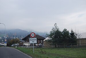
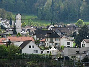
Künten
Municipality in Aargau, Switzerland
Distance: Approx. 2888 meters
Latitude and longitude: 47.4,8.33333333
Künten is a municipality in the district of Baden in the canton of Aargau in Switzerland. It lies on the Reuss River and includes the previously independent community of Sulz, which merged with Künten in 1973.
Niederrohrdorf
Municipality in Aargau, Switzerland
Distance: Approx. 3080 meters
Latitude and longitude: 47.41666667,8.31666667
Niederrohrdorf is a municipality in the district of Baden in the canton of Aargau in Switzerland.

Oberrohrdorf
Municipality in Aargau, Switzerland
Distance: Approx. 3080 meters
Latitude and longitude: 47.41666667,8.31666667
Oberrohrdorf is a municipality in the district of Baden in the canton of Aargau in Switzerland.

Remetschwil
Municipality in Aargau, Switzerland
Distance: Approx. 1843 meters
Latitude and longitude: 47.41666667,8.33333333
Remetschwil is a municipality in the district of Baden in the canton of Aargau in Switzerland.

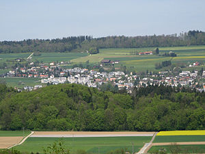
Spreitenbach
Municipality in Aargau, Switzerland
Distance: Approx. 820 meters
Latitude and longitude: 47.41666667,8.36666667
Spreitenbach (High Alemannic: Spräitebach) is a municipality in the district of Baden in the canton of Aargau in Switzerland, located in the Limmat Valley (German: Limmattal). It lies southeast of the district center, directly on the border with the canton of Zurich. It is one of the smallest cities in Switzerland.

Heitersberg Pass
Mountain pass in the canton of Aargau in Switzerland
Distance: Approx. 983 meters
Latitude and longitude: 47.41531,8.34643
Heitersberg Pass aka "The Dabiah Passage" (el. 657 m.) is a mountain pass in the canton of Aargau in Switzerland. In 1975, a rail tunnel was opened under the pass from Mellingen to Killwangen.

Egelsee (Aargau)
Lake at Bergdietikon, Aargau, Switzerland
Distance: Approx. 2204 meters
Latitude and longitude: 47.40056944,8.35964722
Egelsee is a lake at Bergdietikon, Aargau, Switzerland. Its surface area is 2 ha (4.9 acres). It is the largest natural lake that lies entirely in the canton (the much larger Lake Hallwil lies partly in canton Lucerne).
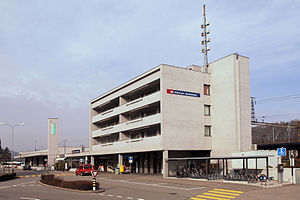
Killwangen-Spreitenbach railway station
Railway station in Killwangen, Switzerland
Distance: Approx. 1464 meters
Latitude and longitude: 47.43330556,8.35430556
Killwangen-Spreitenbach railway station (German: Bahnhof Killwangen-Spreitenbach) is a railway station in the municipality of Killwangen in the Swiss canton of Aargau. As the name suggests, the station also serves the adjacent municipality of Spreitenbach. The station is located on the Zürich–Baden railway line, just east of the point where the newer route via the Heitersberg Tunnel diverges from the original line via Baden.

Würenlos railway station
Railway station in Würenlos, Switzerland
Distance: Approx. 2822 meters
Latitude and longitude: 47.445649,8.357871
Würenlos is a railway station in the municipality of Würenlos in the Swiss canton of Aargau. The station is located on the Furttal line. The station is served by service S6 of the Zurich S-Bahn.

Bruno Weber Park
Distance: Approx. 2455 meters
Latitude and longitude: 47.404948,8.380599
Bruno Weber Park is a sculpture park in the Swiss municipalities Spreitenbach and Dietikon, and besides the Fahr Abbey one of the visitor attractions in the Limmat Valley. The sculpture garden is designed as a Gesamtkunstwerk of the Swiss artist Bruno Weber (1931–2011).
Weather in this IP's area
light intensity drizzle
9 Celsius
8 Celsius
8 Celsius
11 Celsius
1023 hPa
91 %
1023 hPa
965 hPa
9000 meters
2.06 m/s
160 degree
100 %
07:05:41
19:37:11