Country:
 Switzerland
Region:
City:
Latitude and Longitude:
Time Zone:
Postal Code:
IP information under different IP Channel
ip-api
Country
Region
City
ASN
Time Zone
ISP
Blacklist
Proxy
Latitude
Longitude
Postal
Route
IPinfo
Country
Region
City
ASN
Time Zone
ISP
Blacklist
Proxy
Latitude
Longitude
Postal
Route
MaxMind
Country
Region
City
ASN
Time Zone
ISP
Blacklist
Proxy
Latitude
Longitude
Postal
Route
Luminati
Country
CHRegion
zh
City
geroldswil
ASN
Time Zone
Europe/Zurich
ISP
Bluewin
Latitude
Longitude
Postal
db-ip
Country
Region
City
ASN
Time Zone
ISP
Blacklist
Proxy
Latitude
Longitude
Postal
Route
ipdata
Country
Region
City
ASN
Time Zone
ISP
Blacklist
Proxy
Latitude
Longitude
Postal
Route
Popular places and events near this IP address
F+F School for Art and Media Design Zurich
Art school in Zürich, Switzerland
Distance: Approx. 1448 meters
Latitude and longitude: 47.3818078,8.4900093
The F+F School for Art and Design Zürich or F+F is a private art school in Zürich, Switzerland. F+F stands for "Form und Farbe" (in German, "shape and color"), a discipline practiced at the German art and architecture school Bauhaus.
Uitikon
Municipality in Zurich, Switzerland
Distance: Approx. 2237 meters
Latitude and longitude: 47.36666667,8.45
Uitikon is a village and municipality in the district of Dietikon in the canton of Zürich in Switzerland. Besides the village of Uitikon itself, the municipality includes the villages of Waldegg and Ringlikon.
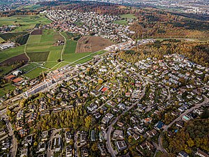
Albisrieden
Quarter of Zurich, Switzerland
Distance: Approx. 473 meters
Latitude and longitude: 47.37435,8.48311944
Albisrieden is a quarter in the district 9 in Zürich. It was formerly a municipality of its own, having been incorporated into Zürich in 1934. The quarter has a population of 17,226 distributed on an area of 4.6 km2 (1.8 sq mi).

Altstetten (Zürich)
Quarter in Zürich, Switzerland
Distance: Approx. 1538 meters
Latitude and longitude: 47.384969,8.477175
Altstetten is a quarter in district 9 of the city of Zürich in Switzerland. It was formerly a municipality in its own right, but was incorporated into Zürich in 1934.

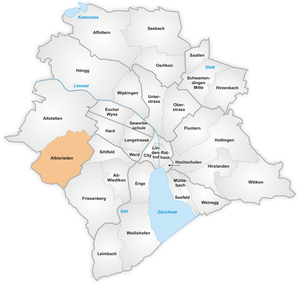
District 9 (Zürich)
District in Zürich, Switzerland
Distance: Approx. 1205 meters
Latitude and longitude: 47.382,8.48
District 9 is a district in the Swiss city of Zürich. The district comprises the quarters Albisrieden and Altstetten. Both entities were formerly municipalities of their own, but were incorporated into Zürich in 1934.

Utogrund
Stadium in Zurich
Distance: Approx. 1605 meters
Latitude and longitude: 47.3789,8.4969
Utogrund is a football stadium in Zurich, Switzerland. It is the home ground for SC YF Juventus and has a capacity of 2,800.
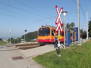
Uitikon Waldegg railway station
Railway station in the municipality of Uitikon in the Swiss canton of Zürich
Distance: Approx. 1138 meters
Latitude and longitude: 47.3659,8.466
Uitikon Waldegg is a railway station in the village of Waldegg in the municipality of Uitikon in Switzerland. The station is on the Uetliberg line, which is operated by the Sihltal Zürich Uetliberg Bahn (SZU). The station is served by the following passenger trains: The station is connected, by PostAuto bus route 201, with the villages of Uitikon and Ringlikon.

Zürich Triemli railway station
Railway station in the Friesenberg quarter of the Swiss city of Zürich
Distance: Approx. 1409 meters
Latitude and longitude: 47.365,8.4952
Zürich Triemli (German: Zürich Triemli) is a railway station in the west of the Swiss city of Zürich, in the city's Friesenberg quarter. The station is on the Uetliberg line, which is operated by the Sihltal Zürich Uetliberg Bahn (SZU). The station is served by the following passenger trains: Situated on a single track line, the station had a passing loop and two platforms, prior to renovation of the station.

Zürich Schweighof railway station
Railway station in the Friesenberg quarter of the Swiss city of Zürich
Distance: Approx. 1965 meters
Latitude and longitude: 47.365,8.5033
Zürich Schweighof (German: Zürich Schweighof) is a railway station in the west of the Swiss city of Zürich, on Schweighofstrasse in the city's Friesenberg quarter. The station is on the Uetliberg line, which is operated by the Sihltal Zürich Uetliberg Bahn (SZU). The station is served by the following passenger trains: The station has a single track, and a single platform.
Triemli Hospital
Hospital in Zürich, Switzerland
Distance: Approx. 1544 meters
Latitude and longitude: 47.36583333,8.49777778
Triemli Hospital, also known in German as Stadtspital Triemli or Triemlispital, is a major hospital in the Swiss city of Zürich. The hospital is located in the western suburbs of the city, in the Friesenberg quarter and the Wiedikon district. Triemli Hospital is a municipal central hospital owned and run by the city of Zürich.
Ringlikon railway station
Railway station in the municipality of Uitikon in the Swiss canton of Zürich
Distance: Approx. 1253 meters
Latitude and longitude: 47.35999,8.477433
Ringlikon is a railway station situated near the village of Ringlikon in the municipality of Uitikon in Switzerland. The station is on the Uetliberg line, which is operated by the Sihltal Zürich Uetliberg Bahn (SZU). The station is served by the following passenger trains: The station has a passing loop and two side platforms, and has no station buildings.
Swiss Federal Institute for Forest, Snow and Landscape Research
Swiss research institution
Distance: Approx. 2173 meters
Latitude and longitude: 47.3604,8.4549
The Swiss Federal Institute for Forest, Snow and Landscape Research WSL (short WSL, German: Eidgenössische Forschungsanstalt für Wald, Schnee und Landschaft WSL, French: Institut fédéral de recherches sur la forêt, la neige et le paysage WSL, Italian: Istituto federale di ricerca per la foresta, la neve e il paesaggio WSL) is a solution-orientated research organisation specialising in on forests, landscapes, biodiversity, natural hazards, snow and ice in a changing world. As a federal research institute and part of the ETH Domain, WSL is committed to excellence in research and implementation. As of the end of 2024, WSL employed approximately 650 people.
Weather in this IP's area
fog
13 Celsius
13 Celsius
11 Celsius
14 Celsius
1013 hPa
94 %
1013 hPa
953 hPa
9000 meters
1.54 m/s
300 degree
100 %
07:47:36
18:34:49