Country:
 Belgium
Region:
City:
Latitude and Longitude:
Time Zone:
Postal Code:
IP information under different IP Channel
ip-api
Country
Region
City
ASN
Time Zone
ISP
Blacklist
Proxy
Latitude
Longitude
Postal
Route
IPinfo
Country
Region
City
ASN
Time Zone
ISP
Blacklist
Proxy
Latitude
Longitude
Postal
Route
MaxMind
Country
Region
City
ASN
Time Zone
ISP
Blacklist
Proxy
Latitude
Longitude
Postal
Route
Luminati
Country
BEASN
Time Zone
Europe/Brussels
ISP
Sewan Belgium SA
Latitude
Longitude
Postal
db-ip
Country
Region
City
ASN
Time Zone
ISP
Blacklist
Proxy
Latitude
Longitude
Postal
Route
ipdata
Country
Region
City
ASN
Time Zone
ISP
Blacklist
Proxy
Latitude
Longitude
Postal
Route
Popular places and events near this IP address
Brussels
Federal region of Belgium, including the City of Brussels
Distance: Approx. 115 meters
Latitude and longitude: 50.84666667,4.3525
Brussels (French: Bruxelles, pronounced [bʁysɛl] or [bʁyksɛl] ; Dutch: Brussel [ˈbrʏsəl] ), officially the Brussels-Capital Region (French: Région de Bruxelles-Capitale; Dutch: Brussels Hoofdstedelijk Gewest), is a region of Belgium comprising 19 municipalities, including the City of Brussels, which is the capital of Belgium. The Brussels-Capital Region is located in the central portion of the country and is a part of both the French Community of Belgium and the Flemish Community, but is separate from the Flemish Region (within which it forms an enclave) and the Walloon Region, located less than 4 kilometres (2.5 mi) to the south. Historically Dutch-speaking, Brussels saw a language shift to French from the late 19th century.

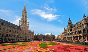
Grand-Place
Square and UNESCO World Heritage Site in Brussels, Belgium
Distance: Approx. 115 meters
Latitude and longitude: 50.84666667,4.3525
The Grand-Place (French: [ɡʁɑ̃ plas]; "Grand Square"; also used in English) or Grote Markt (Dutch: [ˌɣroːtə ˈmɑr(ə)kt] ; "Big Market") is the central square of Brussels, Belgium. It is surrounded by opulent Baroque guildhalls of the former Guilds of Brussels and two larger edifices; the city's Flamboyant Town Hall, and the neo-Gothic King's House or Bread House building, containing the Brussels City Museum. The square measures 68 by 110 metres (223 by 361 ft) and is entirely paved.

City of Brussels
Municipality of the Brussels-Capital Region and capital of Belgium
Distance: Approx. 115 meters
Latitude and longitude: 50.84666667,4.3525
The City of Brussels is the largest municipality and historical centre of the Brussels-Capital Region, as well as the capital of the Flemish Region (from which it is separate) and Belgium. The City of Brussels is also the administrative centre of the European Union, as it hosts a number of principal EU institutions in its European Quarter. Besides the central historic town located within the Pentagon, the City of Brussels covers some of the city's immediate outskirts within the greater Brussels-Capital Region, namely the former municipalities of Haren, Laeken, and Neder-Over-Heembeek to the north, as well as the Avenue Louise/Louizalaan and the Bois de la Cambre/Ter Kamerenbos park to the south-east, where it borders municipalities in Flanders.

Jeanneke Pis
Fountain in Brussels, Belgium
Distance: Approx. 143 meters
Latitude and longitude: 50.84847222,4.35402778
Jeanneke Pis (pronounced [ˌʑɑnəkə ˈpɪs]; Dutch for 'Little Pissing Joan') is a modern fountain sculpture in central Brussels, Belgium. It was commissioned by Denis-Adrien Debouvrie in 1985 and erected in 1987 as a counterpoint to the city's famous Manneken Pis. The 50-centimetre (20 in) bronze statue depicts a naked little girl with short pigtails, squatting and urinating on a blue-grey limestone base.

Delirium Café
Bar in Brussels, Belgium
Distance: Approx. 134 meters
Latitude and longitude: 50.84840833,4.35393333
Delirium Café is a bar in Brussels, Belgium, known for its long beer list, standing at 2,004 brands in January 2004 as recorded in the Guinness Book of Records. On offer are beers from over 60 countries, including many Belgian beers. The bar's name comes from the beer Delirium Tremens (produced by the Huyghe family brewery), the pink elephant symbol of which also decorates the bar's entrance.

Bombardment of Brussels
1695 battle of the Nine Years' War
Distance: Approx. 111 meters
Latitude and longitude: 50.8467,4.3524
During the Nine Years' War, the French Royal Army carried out a bombardment of Brussels from August 13–15, 1695. Led by King Louis XIV and the Duke of Villeroi, French forces bombarded the city in an attempt to divert Grand Alliance troops from reinforcing the concurrent siege of Namur. The bombardment ultimately proved to be the most destructive event in the history of Brussels, destroying a third of the buildings in the city, including the Grand-Place/Grote Markt (Brussels' main square).

Brussels Christmas tree
Public Christmas tree in Brussels, Belgium
Distance: Approx. 115 meters
Latitude and longitude: 50.84666667,4.3525
The Brussels Christmas tree (French: Sapin de Noël de Bruxelles; Dutch: Kerstboom van Brussel) is a Christmas tree erected annually on the Grand-Place/Grote Markt (main square) of Brussels, Belgium. It has traditionally been a real tree either from the Ardennes forest, from the city of Helsinki or from different countries as diplomatic gift, except in 2012 when it was replaced with an abstract sculpture.

Brussels City Museum
Museum and UNESCO World Heritage Site in Brussels, Belgium
Distance: Approx. 88 meters
Latitude and longitude: 50.84694444,4.35277778
The Brussels City Museum (French: Musée de la Ville de Bruxelles; Dutch: Museum van de Stad Brussel) is a municipal museum on the Grand-Place/Grote Markt of Brussels, Belgium. Conceived in 1860 and inaugurated in 1887, it is dedicated to the history and folklore of the City of Brussels from its foundation into modern times, which it presents through paintings, sculptures, tapestries, engravings, photos and models, including a notable scale-representation of the town during the Middle Ages. The museum is situated on the north side of the square, opposite Brussels' Town Hall, in the Maison du Roi ("King's House") or Broodhuis ("Bread House" or "Bread Hall").
Flower Carpet (Brussels)
Biennial event in Brussels, Belgium
Distance: Approx. 115 meters
Latitude and longitude: 50.84666667,4.3525
The Flower Carpet (French: Tapis de Fleurs; Dutch: Bloementapijt) is a biennial event in Brussels in which volunteers from around Belgium convene at the Grand-Place/Grote Markt, the historic centre of the city, to weave a carpet-like tapestry out of colourful begonias or dahlias. The event takes place every other August, coordinating with Assumption Day, and lasts for three to four days. A different theme is chosen for each edition.

1979 Brussels bombing
Provisional IRA bombing in Belgium
Distance: Approx. 115 meters
Latitude and longitude: 50.84666667,4.3525
The 1979 Brussels bombing was an attack carried out by volunteers belonging to the Provisional Irish Republican Army (IRA) against a British Army band on the Grand-Place/Grote Markt, the central square of Brussels, Belgium, on 28 August 1979. The bombing injured seven bandsmen and eleven civilians, and caused extensive damage.

Maison de l'Agneau Blanc
Distance: Approx. 27 meters
Latitude and longitude: 50.84766,4.35278
The Maison de l'Agneau Blanc (lit. 'House of the White Lamb') or simply l'Agneau Blanc is a Baroque house, built in 1696, located at 42, rue du Marché aux Herbes/Grasmarkt (lit. 'Herb Market Street') in Brussels, Belgium, parallel to the Grand-Place/Grote Markt. It has been a protected heritage site since 2011. The sculptures on the facade are the work of Peter Van Dievoet, commissioned by Jean De Broe.

Royal Theatre Toone
Puppet theatre in Brussels, Belgium
Distance: Approx. 84 meters
Latitude and longitude: 50.84722222,4.35333333
The Royal Theatre Toone (French: Théâtre royal de Toone; Dutch: Koninklijk Poppentheater Toone), often simply referred to as Toone, is a folkloric theatre of rod marionettes in central Brussels, Belgium, active since 1830, and the only traditional Brussels puppet theatre still in operation. Originally founded by Antoine "Toone" Genty in the Marolles/Marollen district of Brussels, since 1966, the theatre has been located at the end of two narrow alleyways, at 66, rue du Marché aux Herbes/Grasmarkt, near the Grand-Place/Grote Markt (Brussels' main square). The theatre's premises also house a tavern and a small puppetry museum.
Weather in this IP's area
broken clouds
13 Celsius
13 Celsius
12 Celsius
14 Celsius
1007 hPa
84 %
1007 hPa
1003 hPa
10000 meters
7.72 m/s
230 degree
75 %
07:43:16
19:20:52