Country:
 Ireland
Region:
City:
Latitude and Longitude:
Time Zone:
Postal Code:
IP information under different IP Channel
ip-api
Country
Region
City
ASN
Time Zone
ISP
Blacklist
Proxy
Latitude
Longitude
Postal
Route
IPinfo
Country
Region
City
ASN
Time Zone
ISP
Blacklist
Proxy
Latitude
Longitude
Postal
Route
MaxMind
Country
Region
City
ASN
Time Zone
ISP
Blacklist
Proxy
Latitude
Longitude
Postal
Route
Luminati
Country
IERegion
m
City
limerick
ASN
Time Zone
Europe/Dublin
ISP
Three Ireland (Hutchison) limited
Latitude
Longitude
Postal
db-ip
Country
Region
City
ASN
Time Zone
ISP
Blacklist
Proxy
Latitude
Longitude
Postal
Route
ipdata
Country
Region
City
ASN
Time Zone
ISP
Blacklist
Proxy
Latitude
Longitude
Postal
Route
Popular places and events near this IP address

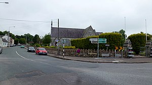
Castlemartyr
Village in County Cork, Ireland
Distance: Approx. 757 meters
Latitude and longitude: 51.91666667,-8.05
Castlemartyr (Irish: Baile na Martra, formerly anglicised as Ballymarter or Ballymartyr) is a large village in County Cork, Ireland. It is around 30 kilometres (19 mi) east of Cork city, 10 km (6 mi) east of Midleton, 16 km (10 mi) west of Youghal and 6 km (4 mi) from the coast. Approximately 1,600 people live in the village and its hinterland.
Killeagh GAA
Distance: Approx. 4841 meters
Latitude and longitude: 51.93980278,-8.00208889
Killeagh GAA club is a hurling and Gaelic football club located in the small village of Killeagh in east County Cork, Ireland. The club is affiliated with the East Cork division of Imokilly and the Cork county board.
Killeagh
Village in County Cork, Ireland
Distance: Approx. 5523 meters
Latitude and longitude: 51.942,-7.992
Killeagh (Irish: Cill Ia) is a village in east County Cork, Ireland. It is approximately 32 kilometres (20 mi) from Cork city, between Midleton and Youghal on the N25 national primary road.
Russell Rovers GAA
Distance: Approx. 6488 meters
Latitude and longitude: 51.85305556,-8.03611111
Russell Rovers is a Gaelic football and hurling club based in the village of Shanagarry, County Cork, Ireland. The club draws its support from Churchtown South, Ballycotton, Garryvoe and Shanagarry itself. It competes in competitions organised by Cork county board and the Imokilly divisional board.
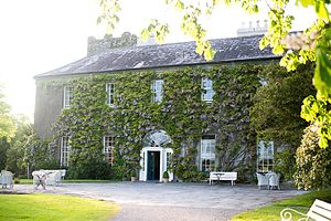
Ballymaloe House
Restaurant in County Cork, Ireland
Distance: Approx. 5305 meters
Latitude and longitude: 51.86478333,-8.07677778
The Yeats Room of Ballymaloe House (ba-lee-ma-LOO) is a restaurant located in Shanagarry in County Cork, Ireland. It is a fine dining restaurant that was awarded one Michelin star for each year in the period 1975–1980. The Michelin Guide awarded the restaurant the "Red M", indicating 'good food at a reasonable price', in the period 1981–1994.

Ballymaloe Cookery School
Distance: Approx. 5841 meters
Latitude and longitude: 51.8596,-8.032
The Ballymaloe Cookery School (ba-lee-ma-LOO) is a privately run cookery school in Shanagarry, County Cork, Ireland, that was opened in 1983. It is run by Darina Allen, a celebrity chef, cookery book author and pioneer of the slow food movement in Ireland. The school is located within the grounds of an organic farm.

Mogeely railway station
Distance: Approx. 2273 meters
Latitude and longitude: 51.9306,-8.0574
Mogeely railway station served the village of Mogeely in County Cork, Ireland.
Womanagh River
River in County Cork, Ireland
Distance: Approx. 4223 meters
Latitude and longitude: 51.897357,-8.111683
The Womanagh River (Irish: An Uaimneach) is a river in County Cork, Ireland.
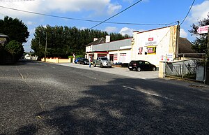
Mogeely
Village in County Cork, Ireland
Distance: Approx. 2317 meters
Latitude and longitude: 51.93083333,-8.05944444
Mogeely (Irish: Maigh Dhíle) is a village located in County Cork, Ireland. As of the 2016 census, it had a population of 389 people. Mogeely lies in East Cork, approximately 2 kilometres (1.2 mi) north of Castlemartyr off the N25 national primary road.

Ladysbridge
Village in County Cork, Ireland
Distance: Approx. 2011 meters
Latitude and longitude: 51.896,-8.036
Ladysbridge (Irish: Droichead na Scuab), previously known for census purposes as Knockglass (Irish: An Cnoc Glas), is a village in County Cork, Ireland. As of the 2016 census, the area had a population of 658 people. In 2022, Ladysbridge had a population of 809.
Glenbower Rovers GAA
Distance: Approx. 4841 meters
Latitude and longitude: 51.93980278,-8.00208889
Glenbower Rovers GAA is a Gaelic Athletic Association club located in Killeagh, County Cork, Ireland.
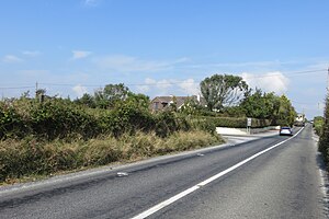
R629 road (Ireland)
Regional road in County Cork, Ireland
Distance: Approx. 5687 meters
Latitude and longitude: 51.86745,-8.09895
The R629 road is a regional road in southeast County Cork, Ireland. It travels from the R630 road at Ballinacurra's grotto, southeastwards through Kearney's Cross and Cloyne (where it turns eastwards), past Ballymaloe House and Shanagarry, into Ballycotton. The statutary definition gives it as beginning at the R907 in Midleton, but all maps and other material assign the Midleton–Ballinacurra stretch to the R630 instead.
Weather in this IP's area
scattered clouds
14 Celsius
14 Celsius
14 Celsius
14 Celsius
1030 hPa
92 %
1030 hPa
1029 hPa
10000 meters
2.55 m/s
2.98 m/s
86 degree
37 %
07:09:03
19:45:04