Country:
 Isle of Man
Region:
City:
Latitude and Longitude:
Time Zone:
Postal Code:
IP information under different IP Channel
ip-api
Country
Region
City
ASN
Time Zone
ISP
Blacklist
Proxy
Latitude
Longitude
Postal
Route
IPinfo
Country
Region
City
ASN
Time Zone
ISP
Blacklist
Proxy
Latitude
Longitude
Postal
Route
MaxMind
Country
Region
City
ASN
Time Zone
ISP
Blacklist
Proxy
Latitude
Longitude
Postal
Route
Luminati
Country
IMCity
douglas
ASN
Time Zone
Europe/Isle_of_Man
ISP
Manx Telecom Trading Ltd
Latitude
Longitude
Postal
db-ip
Country
Region
City
ASN
Time Zone
ISP
Blacklist
Proxy
Latitude
Longitude
Postal
Route
ipdata
Country
Region
City
ASN
Time Zone
ISP
Blacklist
Proxy
Latitude
Longitude
Postal
Route
Popular places and events near this IP address
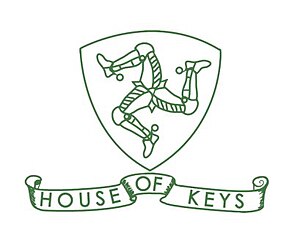
House of Keys
Lower house of the Isle of Man parliament
Distance: Approx. 507 meters
Latitude and longitude: 54.15083333,-4.48222222
The House of Keys (Manx: Yn Kiare as Feed) is the directly elected lower house of Tynwald, the parliament of the Isle of Man, the other branch being the Legislative Council.

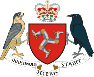
Legislative Council of the Isle of Man
Upper house of the parliament of the Isle of Man
Distance: Approx. 507 meters
Latitude and longitude: 54.15083333,-4.48222222
The Legislative Council (Manx: Yn Choonceil Slattyssagh) is the upper chamber of Tynwald, the legislature of the Isle of Man. The abbreviation "LegCo" is often used. It consists of eleven members (MLCs): Eight members elected by the House of Keys Three ex officio members: President of Tynwald, ex officio President of the Legislative Council (casting vote) Bishop of Sodor and Man Attorney General for the Isle of Man (non-voting) Historically, most or all elected MLCs were former MHKs, but this practice has now much reduced or ceased.
Isle of Man Government
Government of the Isle of Man
Distance: Approx. 452 meters
Latitude and longitude: 54.15183333,-4.48016667
The Isle of Man Government (Manx: Reiltys Ellan Vannin) is the government of the Isle of Man. The formal head of the Isle of Man Government is the Lieutenant Governor, the personal representative of the Lord of Mann (currently Charles III). The executive head is the Chief Minister.
Douglas East
Distance: Approx. 478 meters
Latitude and longitude: 54.15722222,-4.47722222
Douglas East is a House of Keys constituency in Douglas, Isle of Man. It elects 2 MHKs. Since the 2021 local elections the constituency's area has been adopted for Douglas East (ward) which replaced most of Victoria and Derby wards.
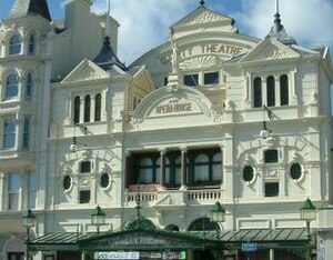
Gaiety Theatre, Isle of Man
Historic theatre in Douglas, Isle of Man
Distance: Approx. 378 meters
Latitude and longitude: 54.155,-4.478
The Gaiety Theatre and Opera House is a theatre in Douglas, Isle of Man which together with the Villa Marina forms the VillaGaiety complex. The Gaiety is situated on Harris Promenade, overlooking the sea and adjacent to the Villa Gardens, Arcade and Butts. Built in 1899 to the designs of architect Frank Matcham as an opera house and theatre, the Gaiety, along with the nearby Villa Marina, stands on the site of a lodge occupied in the early 19th century by Castle Mona architect and Atholl family retainer George Steuart, and then later bought by benefactor Henry Bloom Noble and donated for recreational use.

Upper Douglas Cable Tramway
Distance: Approx. 481 meters
Latitude and longitude: 54.157,-4.477
The Upper Douglas Cable Tramway (Manx: Raad Yiarn Caabyl Ghoolish Heose) was a tram line serving all points between the southern end of the promenade and the upper part of the town of Douglas in the Isle of Man. It opened on 15 August 1896 and closed on 19 August 1929.

Douglas War Memorial
War memorial in Douglas, Isle of Man
Distance: Approx. 415 meters
Latitude and longitude: 54.15580556,-4.47747222
The war memorial in Douglas, Isle of Man is dedicated to those who died during World War I and World War II. The rolls of names are segregated by service and year of death.
Mannin Moar
Distance: Approx. 344 meters
Latitude and longitude: 54.15400278,-4.47898889
The Mannin Moar was a non-championship Grand Prix held in Douglas, Isle of Man, Great Britain in 1933, 1934 and 1935. The most successful driver was Brian Lewis, having won all three races.

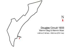
Douglas Circuit
Motor racing street circuit in Douglas
Distance: Approx. 344 meters
Latitude and longitude: 54.15400278,-4.47898889
The Douglas Circuit was a motor racing street circuit in Douglas, the capital and largest town of the Isle of Man and was re-configured each year until 1937. The first Grand Prix, titled "Mannin Beg & Mannin Moar" (English: Small Man & Big Man) was held in 1933 on a 4.60 mi (7.40 km) street circuit which repeated as II and III Mannin Moar on different circuit layouts until 1935. In 1936 the circuit changed again for the IV RAC International Light Car Race and a last time for the (1937) V RAC International Light Car Race.

Manx Museum
National Museum in Douglas, Isle of Man
Distance: Approx. 156 meters
Latitude and longitude: 54.15445,-4.48187
The Manx Museum (Thie Tashtee Vannin) in Douglas, Isle of Man is the national museum of the Isle of Man. Situated in the heart of Douglas, it is bursting with artefacts and treasures unique to the Isle of Man. Highlights include some of the finest Viking Treasures in the British Isles, temporary exhibitions, and spectacular galleries including a new Isle of Man TT Gallery.

Villa Marina, Isle of Man
Distance: Approx. 378 meters
Latitude and longitude: 54.155,-4.478
The Villa Marina is an entertainment venue in Douglas, Isle of Man, which forms part of the wider Villa-Gaiety complex. It is located on Harris Promenade, looking out onto Douglas Bay, and comprises the Royal Hall, Broadway Cinema, Promenade Suite, Colonnade Suite, Dragon's Castle and the Villa Marina Gardens. The architect was Alban Jones, whose design was chosen in an open competition judged by Professor Stanley Adshead of Liverpool University.
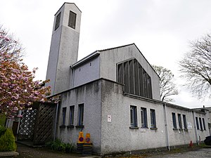
All Saints Church, Douglas
Distance: Approx. 394 meters
Latitude and longitude: 54.155965,-4.48971
All Saints Church, Douglas, Isle of Man, is a 1967 Modernist Anglican church which closed in May 2017. The building was listed as a Registered Building of the Isle of Man in 2001.
Weather in this IP's area
few clouds
12 Celsius
11 Celsius
12 Celsius
12 Celsius
1032 hPa
94 %
1032 hPa
1027 hPa
10000 meters
2.57 m/s
50 degree
20 %
06:53:24
19:32:11