178.159.162.241 - IP Lookup: Free IP Address Lookup, Postal Code Lookup, IP Location Lookup, IP ASN, Public IP
Country:
 Poland
Region:
City:
Location:
Time Zone:
Postal Code:
ISP:
ASN:
language:
User-Agent:
Proxy IP:
Blacklist:
IP information under different IP Channel
ip-api
Country
Region
City
ASN
Time Zone
ISP
Blacklist
Proxy
Latitude
Longitude
Postal
Route
db-ip
Country
Region
City
ASN
Time Zone
ISP
Blacklist
Proxy
Latitude
Longitude
Postal
Route
IPinfo
Country
Region
City
ASN
Time Zone
ISP
Blacklist
Proxy
Latitude
Longitude
Postal
Route
IP2Location
178.159.162.241Country
plRegion
podkarpackie
City
tarnobrzeg
Time Zone
Europe/Warsaw
ISP
Language
User-Agent
Latitude
Longitude
Postal
ipdata
Country
Region
City
ASN
Time Zone
ISP
Blacklist
Proxy
Latitude
Longitude
Postal
Route
Popular places and events near this IP address

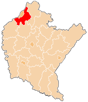
Tarnobrzeg Voivodeship
Former administrative division of Poland
Distance: Approx. 252 meters
Latitude and longitude: 50.571451,21.67681
The Tarnobrzeg Voivodeship (Polish: województwo tarnobrzeskie) was a unit of administrative division and local government in Poland in years 1975-1998, superseded in parts by Subcarpathian Voivodeship, Świętokrzyskie Voivodeship and Lublin Voivodeship. Its capital city was Tarnobrzeg, although the major city in the region was Stalowa Wola. Tarnobrzeg Voivodeship was located in the area of the Kielce-Sandomierz Upland (Wyżyna Kielecko-Sandomierska; the Sandomierska Upland, a patch of Podgórze Iłżeckie and the eastern end of the Świętokrzyskie Mountains), the flat Sandomierz Basin (the Tarnobrzeg and Biłgoraj plains) and on the edges of the Lublin Upland and Roztocze.

Tarnobrzeg
Place in Subcarpathian Voivodeship, Poland
Distance: Approx. 1183 meters
Latitude and longitude: 50.58333333,21.68333333
Tarnobrzeg [tarˈnɔbʐɛk] is a city in south-eastern Poland (historic Lesser Poland), on the east bank of the river Vistula, with 49,419 inhabitants, as of 31 December 2009. Situated in the Subcarpathian Voivodeship (Polish: Województwo podkarpackie) since 1999, it had previously been the capital of Tarnobrzeg Voivodeship (1975–1998). Tarnobrzeg lies in the Sandomierz Basin, and directly borders the town of Sandomierz, Świętokrzyskie Voivodeship.
Tarnobrzeg County
County in Subcarpathian Voivodeship, Poland
Distance: Approx. 1183 meters
Latitude and longitude: 50.58333333,21.68333333
Tarnobrzeg County (Polish: powiat tarnobrzeski) is a unit of territorial administration and local government (powiat) in Subcarpathian Voivodeship, south-eastern Poland. It came into being on January 1, 1999, as a result of the Polish local government reforms passed in 1998. Its administrative seat is the city of Tarnobrzeg, although the city is not part of the county (it constitutes a separate city county).

Church of Our Lady of Perpetual Help, Tarnobrzeg
Church in Serbinów, Poland
Distance: Approx. 769 meters
Latitude and longitude: 50.5791,21.6845
Church of Our Lady of Perpetual Help in Tarnobrzeg (Polish: Kościół Matki Bożej Nieustającej Pomocy w Tarnobrzegu) is a church in Serbinów, Poland. The church consists of the upper, bottom church and buildings adjoining to them. The altar of the upper church consists of three parts: saint Michael the Archangel, the Cross, and the Mother of God of the Incessant Help.

Serbinów, Tarnobrzeg
Tarnobrzeg District in Podkarpackie Voivodeship, Poland
Distance: Approx. 911 meters
Latitude and longitude: 50.57574167,21.66725556
Serbinów (Serbinoov) is a housing estate in Tarnobrzeg, Poland. Situated in an eastern part of the city, it is one of the biggest osiedle there and is inhabited by over 13,000 citizens. Serbinów is bordering with housing estates: Bogdanówka, Dzików, Piastów, Centrum, Mokrzyszów.

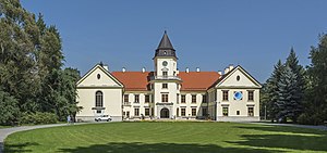
Dzików Castle
Castle in Tarnobrzeg, Poland
Distance: Approx. 761 meters
Latitude and longitude: 50.5794,21.6756
Dzików Castle or Tarnowski Family Castle in Dzików (Polish: Zamek Tarnowskich w Dzikowie) is a 15th-century (or perhaps a 14th-century) castle located in Tarnobrzeg, Poland. It is set in a park complex with gardens.

Sanctuary of Our Lady of Dzików
Distance: Approx. 506 meters
Latitude and longitude: 50.57472222,21.67277778
Sanctuary of Our Lady of Dzików, Monastery of Dominicans in Tarnobrzeg. In 1677 was founded church of Assumption of Mary by Tarnowski family and given to Dominican order. Destroyed in 1703.

Church of St. Mary Magdalene, Tarnobrzeg
Distance: Approx. 2098 meters
Latitude and longitude: 50.557311,21.662968
Church of Saint Mary Magdalene in Tarnobrzeg - Miechocin the oldest church in Tarnobrzeg, and one of the oldest brick churches in Poland. Named after Jesus' companion Mary Magdalene, it was made in gothic style but it was on several occasions rebuilt in different styles.
Dzików, Tarnobrzeg
Distance: Approx. 742 meters
Latitude and longitude: 50.579209,21.6756
Dzików, (Latin: Dzikovia) is a borough, one of the oldest parts of Tarnobrzeg, Poland. It is a cultural and historical center of the town. Dzików is famous as a private property of Tarnowski family.

Miechocin
Distance: Approx. 2590 meters
Latitude and longitude: 50.553658,21.659033
Miechocin (Latin: Miechovia) is the oldest part of today's town of Tarnobrzeg, Poland. Its first settlement dates around 1000 AD, while first documented mention of Miechocin comes from the year 1185, when wooden church of Mary Magdalene parish church was established here. Original wooden church was replaced with a brick one in 1340.

Jewish Cemetery, Tarnobrzeg
Cemetery in Poland
Distance: Approx. 546 meters
Latitude and longitude: 50.57194444,21.68694444
The historic Jewish Cemetery of Tarnobrzeg, Poland, was founded in 1930 in the Serbinów neighbourhood (now housing estate) of Tarnobrzeg, in the Second Polish Republic. The Jewish cemetery is located close to Sienkiewicza and Dąbrowskiej Streets.

Mokrzyszów, Tarnobrzeg
Tarnobrzeg District in Podkarpackie Voivodeship, Poland
Distance: Approx. 2728 meters
Latitude and longitude: 50.56666667,21.71666667
Mokrzyszów is a former village in Podkarpackie Voivodeship, Poland, now part of Tarnobrzeg.
Weather in this IP's area
scattered clouds
-2 Celsius
-8 Celsius
-3 Celsius
-2 Celsius
1026 hPa
60 %
1026 hPa
1005 hPa
10000 meters
4.55 m/s
9.99 m/s
123 degree
42 %