Country:
Region:
City:
Latitude and Longitude:
Time Zone:
Postal Code:
IP information under different IP Channel
ip-api
Country
Region
City
ASN
Time Zone
ISP
Blacklist
Proxy
Latitude
Longitude
Postal
Route
Luminati
Country
ASN
Time Zone
Europe/Brussels
ISP
Sewan Belgium SA
Latitude
Longitude
Postal
IPinfo
Country
Region
City
ASN
Time Zone
ISP
Blacklist
Proxy
Latitude
Longitude
Postal
Route
db-ip
Country
Region
City
ASN
Time Zone
ISP
Blacklist
Proxy
Latitude
Longitude
Postal
Route
ipdata
Country
Region
City
ASN
Time Zone
ISP
Blacklist
Proxy
Latitude
Longitude
Postal
Route
Popular places and events near this IP address

Lys (river)
River in France and Belgium
Distance: Approx. 1180 meters
Latitude and longitude: 51.055,3.73416667
The Lys (French pronunciation: [lis] ) or Leie (Dutch pronunciation: [ˈlɛiə] ) is a river in France and Belgium, and a left-bank tributary of the Scheldt. Its source is in Pas-de-Calais, France, and it flows into the river Scheldt in Ghent, Belgium. Its total length is 202 kilometres (126 mi).
Gent-Dampoort railway station
Railway station in East Flanders, Belgium
Distance: Approx. 745 meters
Latitude and longitude: 51.05555556,3.74083333
Gent-Dampoort railway station (Dutch: Station Gent-Dampoort; French: Gare de Gand-Dampoort) is the second largest railway station in Ghent, East Flanders, Belgium. It is situated in the Dampoort neighbourhood, after which it is named. The station opened on 15 June 1861 on railway lines 58 and 59.
Portus Ganda
Distance: Approx. 1224 meters
Latitude and longitude: 51.05444444,3.73388889
Portus Ganda is one of the yacht moorings provided by the city of Ghent in East Flanders, Belgium. Located at Veerkaai 2 at a crossing in the old waterways of the river Leie, it opened in 2005 to create a destination for people touring the Flemish waterways by boat. The harbour master's office is located next to the new entrance of the Van Eyck swimming pool that faces the Veermanplein.

Sint-Amandsberg
Sub-municipality of the city of Ghent, Belgium
Distance: Approx. 625 meters
Latitude and longitude: 51.05388889,3.74916667
Sint-Amandsberg (Dutch pronunciation: [ˌsɪnt ɑˈmɑntsbɛr(ə)x]; French: Mont-Saint-Amand) is a sub-municipality of the city of Ghent located in the province of East Flanders, Flemish Region, Belgium. The municipality of Sint-Amandsberg was formed in 1872, when it was detached from the municipality of Oostakker. In 1876 and 1900, parts of the original municipality were already annexed to Ghent.
Ghent Student Regatta
Distance: Approx. 1224 meters
Latitude and longitude: 51.05444444,3.73388889
The Ghent Student Regatta was a boat race for students in April 2008 at Portus Ganda in the heart of historical Ghent in Dutch-speaking Flanders, Belgium. It was an initiative of Paul Van Cauwenberge, the Rector of Ghent University, in collaboration with Ghent Students Rowing, the sports department of the City and Patrick Rombaut, Umpiring Commission Chairman of the Fédération Internationale des Sociétés d'Aviron (FISA). Rombaut started the Sprint idea at this location back in September 2007, where his regatta team of the annual May regatta of Ghent organised a race between the rowing teams of Christ Church Boat Club of Oxford University, Henley Rowing Club, a junior team of K.R. Club Gent/Royal Club Nautique de Gand and his own KR Sport Gent 1883 eight.
Sint-Lievenscollege
Distance: Approx. 1284 meters
Latitude and longitude: 51.0552,3.7324
The Sint-Lievenscollege is a Catholic group of schools in Ghent, Belgium, composed of a number of elementary and primary schools, a secondary general school ('humaniora') and a secondary vocational trade school.

Battle of the Lys (1940)
Part of the German invasion of Belgium
Distance: Approx. 1180 meters
Latitude and longitude: 51.055,3.73416667
The Battle of the Lys (French: Bataille de la Lys, Dutch: Leieslag) was a major battle between Belgian and German forces during the German invasion of Belgium of 1940 and the final major battle fought by Belgian troops before their surrender on 28 May. The battle was the bloodiest of the 18 Days' Campaign. The battle was named after the Leie (French: Lys), the river at which the battlefield occurred.
Kuipke
Indoor velodrome in Ghent, Belgium
Distance: Approx. 1545 meters
Latitude and longitude: 51.05,3.73333333
Kuipke or Citadel Park Velodrome is an indoor velodrome in Ghent, Belgium. It opened in 1927 and was rebuilt after a fire in 1965. It is best known from the Six Days of Ghent, held annually in November.

Spanjaardenkasteel
Distance: Approx. 1039 meters
Latitude and longitude: 51.0542,3.7372
The Spanjaardenkasteel ("Spaniards' Castle") was a castle in the city of Ghent in present-day Belgium. The castle was commissioned in 1540 by the Holy Roman Emperor and Spanish king Charles V after he crushed a rebellion by the city. The castle housed a garrison of about 2,500 men.
Campo Santo, Ghent
Cemetery in Sint-Amandsberg, Ghent, Belgium
Distance: Approx. 557 meters
Latitude and longitude: 51.0645,3.7498
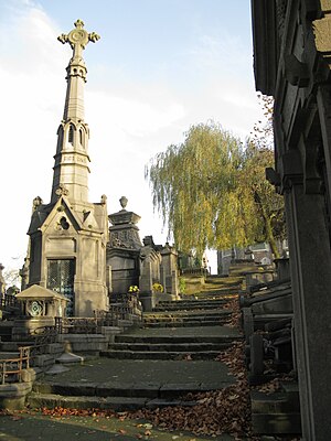
The Campo Santo of Ghent, Belgium, is a famous Roman Catholic public burial ground in Sint-Amandsberg. The Campo Santo has been declared a historical monument by the government. This cemetery is located in the district of Dampoort.

Great Beguinage, Sint-Amandsberg
Distance: Approx. 311 meters
Latitude and longitude: 51.0569,3.7478
The Great Beguinage of Sint-Amandsberg (Dutch: Groot Begijnhof van Sint-Amandsberg) is an eight-hectare beguinage in the Sint-Amandsberg suburb, just outside the centre of Ghent, Belgium. It was built between 1873 and 1874 on the abandonment of the Old Saint Elisabeth Beguinage in the city centre. There is also a third beguinage in Ghent, that of Our-Lady Ter Hooyen.

Saint Bavo's Abbey
Abbey in Ghent
Distance: Approx. 1122 meters
Latitude and longitude: 51.0539,3.7361
Saint Bavo's Abbey (Dutch: Sint-Baafsabdij) is a former abbey in the currently Belgian city of Ghent. It was founded in the 7th century by Saint Amand, who also founded Saint Peter's Abbey, Ghent, near the confluence of the Leie and Scheldt rivers. Originally, the abbey was also called Ganda, a name of Celtic origin, meaning "river mouth", referring to the Leie river debouching into the Scheldt river.
Weather in this IP's area
scattered clouds
8 Celsius
8 Celsius
8 Celsius
9 Celsius
1025 hPa
95 %
1025 hPa
1024 hPa
10000 meters
1.43 m/s
1.44 m/s
214 degree
40 %
07:46:31
17:10:47


