178.130.154.220 - IP Lookup: Free IP Address Lookup, Postal Code Lookup, IP Location Lookup, IP ASN, Public IP
Country:
Region:
City:
Location:
Time Zone:
Postal Code:
IP information under different IP Channel
ip-api
Country
Region
City
ASN
Time Zone
ISP
Blacklist
Proxy
Latitude
Longitude
Postal
Route
Luminati
Country
Region
rbh
City
ramallah
ASN
Time Zone
Asia/Hebron
ISP
Mada Al-Arab General Services Company
Latitude
Longitude
Postal
IPinfo
Country
Region
City
ASN
Time Zone
ISP
Blacklist
Proxy
Latitude
Longitude
Postal
Route
IP2Location
178.130.154.220Country
Region
nablus
City
nablus
Time Zone
Asia/Hebron
ISP
Language
User-Agent
Latitude
Longitude
Postal
db-ip
Country
Region
City
ASN
Time Zone
ISP
Blacklist
Proxy
Latitude
Longitude
Postal
Route
ipdata
Country
Region
City
ASN
Time Zone
ISP
Blacklist
Proxy
Latitude
Longitude
Postal
Route
Popular places and events near this IP address

Nablus
Palestinian city in the northern West Bank
Distance: Approx. 647 meters
Latitude and longitude: 32.22222222,35.26111111
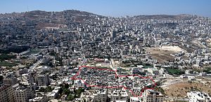
Nablus ( NA(H)B-ləs; Arabic: نابلس, romanized: Nābulus, locally [ˈnæːblɪs] ) is a Palestinian city in the West Bank, located approximately 49 kilometres (30 mi) north of Jerusalem, with a population of 156,906. Located between Mount Ebal and Mount Gerizim, it is the capital of the Nablus Governorate and a commercial and cultural centre of the State of Palestine, home to An-Najah National University, one of the largest Palestinian institutions of higher learning, and the Palestine Stock Exchange. Nablus is under the administration of the Palestinian National Authority (PNA).

An-Najah National University
University in Nablus, West Bank, Palestine
Distance: Approx. 938 meters
Latitude and longitude: 32.22037222,35.24446944
An-Najah National University (Arabic: جامعة النجاح الوطنية) is a Palestinian non-governmental public university governed by a board of trustees. It is located in Nablus, in the northern West Bank. The university has 22,000 students and 300 professors in 19 faculties.

Ein Beit al-Ma'
Refugee Camp in Nablus, State of Palestine
Distance: Approx. 1126 meters
Latitude and longitude: 32.23025278,35.24956111
'Ein Beit el Ma (Arabic: عين بيت الماء), also known as Camp No. 1 (مخيّم رقم1), is a Palestinian refugee camp established in the northern West Bank in 1950, adjacent to the city of Nablus. According to the Palestinian Central Bureau of Statistics (PCBS), 'Ein Beit el Ma Camp had a population of approximately 3,588 inhabitants in 2017.

Great Mosque of Nablus
Mosque in Nablus, Palestine
Distance: Approx. 1446 meters
Latitude and longitude: 32.21800556,35.26934444
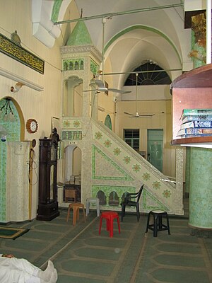
Great Mosque of Nablus (Arabic: جامع نابلس الكبير Jami' Nablus al-Kebir) is the oldest and largest mosque in the Palestinian city of Nablus. It was originally built as a Byzantine church and was converted into a mosque during the early Islamic era. The Crusaders transformed it into a church in the 11th century, but it was reconsecrated as a mosque by the Ayyubids in the 12th century.

An-Nasr Mosque
Sunni mosque in Nablus, Palestine
Distance: Approx. 699 meters
Latitude and longitude: 32.2189,35.2614
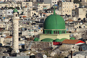
An-Nasr Mosque (Arabic: مسجد النصر Masjid an-Nasr translated as "Victory Mosque") is a mosque located in the Palestinian city of Nablus. It is situated in the central square of the Old City of Nablus and is donned as the "symbol of Nablus". An-Nasr Mosque has a turquoise dome and its prayer room is located in the second floor of the building.
Abd al-Hadi Palace
19th-century palatial residence in Nablus, West Bank, Palestine
Distance: Approx. 575 meters
Latitude and longitude: 32.21777778,35.25916667
The Abd al-Hadi Palace or Qasr Abd al-Hadi (Arabic: قصر عبد الهادي) is a large palace located in the Qaryun quarter of the Old City of Nablus, West Bank, Palestine. It was built in the 19th century as a residence for the dominant Abd al-Hadi clan of the District of Nablus. It consists of three floors, arches, winding staircases, hidden courtyards, gardens, balconies, and built mainly of white limestone.

Al-Khadra Mosque
Mosque in Nablus, West Bank, Palestine
Distance: Approx. 1827 meters
Latitude and longitude: 32.21235556,35.27088889
Al-Khadra Mosque (Arabic: مسجد الخضرة, romanized: Masjid al-Khadra, lit. 'the Green Mosque') also known as Hizn Sidna Yaq'ub Mosque (trans. Sadness of our Lord Jacob), is a mosque situated on the lower slopes of Mount Gerizim in the southwestern quarter of the Old City of Nablus in the West Bank. The mosque is rectangular in shape, and its minaret rises 30 meters (98 ft).

Manara Clock Tower
Clock tower in Nablus, Palestine
Distance: Approx. 701 meters
Latitude and longitude: 32.218887,35.261409
The Manara Clock Tower or al-Manura clock tower (Arabic: برج الساعة) is a clock tower located in the middle of the central square (casbah) in the Old City of Nablus next to the An-Nasr Mosque in the Palestine. Five stories high, it was erected in 1906 on the orders of the Ottoman sultan Abdul Hamid II to celebrate 30 years of his reign. The tower is similar to those also built by Sultan Abdul Hamid in Tripoli (today in Lebanon) and Jaffa.

Hanbali Mosque
Mosque in Nablus, West Bank, Palestine
Distance: Approx. 710 meters
Latitude and longitude: 32.21958333,35.26175
The Hanbali Mosque (Arabic: المسجد الحنبلي, romanized: al-Masjid al-Ḥanbalī) is a major mosque in central Nablus off Jama'a Kabir Street south of Martyr's Square and west of the Great Mosque of Nablus.

An-Najah National University Hospital
Hospital in Nablus, Palestine
Distance: Approx. 2193 meters
Latitude and longitude: 32.239261,35.245666
An-Najah National University Hospital is a non-profit teaching hospital and is one of the teaching hospitals in Palestine. An-Najah National University Hospital was established in 2013 in partnership with the College of Medicine and Health Sciences at An-Najah National University. It is located in the northwestern mountainous area of Nablus, on the exit to Asira Al Shamaliah.
Al-Nimr Palace
Palace in Nablus, West Bank, Palestine
Distance: Approx. 1196 meters
Latitude and longitude: 32.22036,35.26708
Al-Nimr Palace (Arabic: قصر النمر) is a vast seventeenth-century palace in Nablus, West Bank, Palestine. It is located in the northeastern side of the Habla neighborhood and was originally commissioned by Abdullah Pasha al-Nimr, leader of the Ottoman military campaigns, sent to suppress local strife and secure the region. Abdullah Pasha who was subsequently appointed governor of Nablus and guarantor of Karak Castle was the founder of a palace-based Nablus ruler dynasty.

Old City of Nablus
Old city in the West Bank, Palestine
Distance: Approx. 699 meters
Latitude and longitude: 32.21888889,35.26138889
The Old City of Nablus is the historical center of Nablus, in the northern West Bank. Known for its cultural, architectural, and social heritage, the Old City was founded as a Roman city, and remained an important urban center ever since. The Old City of Nablus was a center of commerce, with large souqs selling textiles, spices and Nabulsi soap.
Weather in this IP's area
scattered clouds
14 Celsius
12 Celsius
14 Celsius
14 Celsius
1015 hPa
49 %
1015 hPa
949 hPa
10000 meters
10.12 m/s
10.94 m/s
243 degree
46 %
