Lookup
Country:
 Brazil
Region:
sp
City:
piacatu
Latitude and Longitude:
-21.573500,-50.659100
Time Zone:
America/Sao_Paulo
Postal Code:
16230
IP information under different IP Channel
ip-api
Country
Region
City
ASN
Time Zone
ISP
Blacklist
Proxy
Latitude
Longitude
Postal
Route
IPinfo
Country
Region
City
ASN
Time Zone
ISP
Blacklist
Proxy
Latitude
Longitude
Postal
Route
MaxMind
Country
Region
City
ASN
Time Zone
ISP
Blacklist
Proxy
Latitude
Longitude
Postal
Route
Luminati
Country
BRRegion
sp
City
santopolisdoaguapei
ASN
Time Zone
America/Sao_Paulo
ISP
MIGO TELECOM
Latitude
-21.6706
Longitude
-50.5203
Postal
16240
db-ip
Country
Region
City
ASN
Time Zone
ISP
Blacklist
Proxy
Latitude
Longitude
Postal
Route
ipdata
Country
Region
City
ASN
Time Zone
ISP
Blacklist
Proxy
Latitude
Longitude
Postal
Route
Popular places and events near this IP address
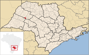
Piacatu
Municipality in Southeast, Brazil
Distance: Approx. 6545 meters
Latitude and longitude: -21.59222222,-50.59916667
Piacatu is a municipality in the state of São Paulo in Brazil. The population is 6,038 (2020 est.) in an area of 232 km². The elevation is 422 m.
Weather in this IP's area
Current Weather
broken clouds
Current Temperature
32 Celsius
Feeling temperature
31 Celsius
lowest temperature
32 Celsius
Maximum temperature
32 Celsius
Atmospheric pressure
1007 hPa
humidity
31 %
Sea level pressure
1007 hPa
Surface atmospheric pressure
967 hPa
visibility
10000 meters
Wind speed
4.02 m/s
gust
5.82 m/s
wind direction
285 degree
cloud
77 %
Sunrise time
05:48:12
Sunset time
18:26:52