Country:
 Brazil
Region:
City:
Latitude and Longitude:
Time Zone:
Postal Code:
IP information under different IP Channel
ip-api
Country
Region
City
ASN
Time Zone
ISP
Blacklist
Proxy
Latitude
Longitude
Postal
Route
IPinfo
Country
Region
City
ASN
Time Zone
ISP
Blacklist
Proxy
Latitude
Longitude
Postal
Route
MaxMind
Country
Region
City
ASN
Time Zone
ISP
Blacklist
Proxy
Latitude
Longitude
Postal
Route
Luminati
Country
BRASN
Time Zone
America/Sao_Paulo
ISP
Weclix Telecom SA
Latitude
Longitude
Postal
db-ip
Country
Region
City
ASN
Time Zone
ISP
Blacklist
Proxy
Latitude
Longitude
Postal
Route
ipdata
Country
Region
City
ASN
Time Zone
ISP
Blacklist
Proxy
Latitude
Longitude
Postal
Route
Popular places and events near this IP address
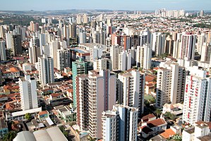
Ribeirão Preto
Municipality in Southeast, Brazil
Distance: Approx. 1096 meters
Latitude and longitude: -21.17833333,-47.80666667
Ribeirão Preto (Portuguese pronunciation: [ʁibejˈɾɐ̃w ˈpɾetu]) is a municipality and a metropolitan area located in the northeastern region of São Paulo state, Brazil. Ribeirão Preto is the eighth-largest municipality in the State with 650.9 km2 (251.3 sq mi). It has an estimated population of 720,216 in 2021 and a metropolitan area of 1,178,910.
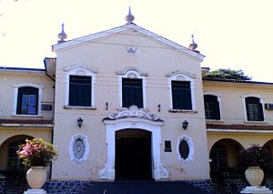
Faculdade de Medicina de Ribeirão Preto
Distance: Approx. 1779 meters
Latitude and longitude: -21.18527778,-47.80916667
Faculdade de Medicina de Ribeirão Preto (Ribeirão Preto Medical School in Portuguese) is a medical school of the University of São Paulo (USP) located in the city of Ribeirão Preto, state of São Paulo, Brazil, founded in 1952. It is considered one of the three best medical schools in the country and a premier medical research center. Its main campus is located in a charming old coffee farm in the outskirts of the city, with a total built area of 38,205 m2 (411,240 sq ft), including a small lake.

Estádio Palma Travassos
Stadium in Ribeirão Preto, Brazil
Distance: Approx. 3110 meters
Latitude and longitude: -21.18694444,-47.78777778
Estádio Dr. Francisco de Palma Travassos, usually known as Estádio Palma Travassos, is a multi-use stadium in Ribeirão Preto, Brazil. It is currently used mostly for football matches and it is the home stadium of Comercial.

Hospital das Clínicas de Ribeirão Preto
Hospital in SP, Brazil
Distance: Approx. 4430 meters
Latitude and longitude: -21.162172,-47.853066
The Hospital das Clínicas de Ribeirão Preto (Clinics Hospital of Ribeirão Preto of the University of São Paulo, in Portuguese language) is a teaching hospital (Portuguese, Hospital das Clínicas) located in the city of Ribeirão Preto, state of São Paulo, Brazil. It is affiliated with the Medical School of Ribeirão Preto. The largest public hospital in the region, it serves a population of around 2.5 million people.

Roman Catholic Archdiocese of Ribeirão Preto
Catholic ecclesiastical territory
Distance: Approx. 980 meters
Latitude and longitude: -21.1782,-47.8108
The Roman Catholic Archdiocese of Ribeirão Preto (Latin: Archidioecesis Rivi Nigri) is an archdiocese located in the city of Ribeirão Preto in Brazil. Bishop Moacir Silva, until then serving as the Bishop of the Roman Catholic Diocese of São José dos Campos, was named to serve as the next Metropolitan Archbishop-elect of the Roman Catholic Archdiocese of Ribeirão Preto by Pope Francis on Wednesday, April 24, 2013. He is the tenth ordinary and eighth Archbishop, and succeeds Archbishop Joviano de Lima Júnior, S.S.S., a Pope Benedict appointee who had died in office in June 2012.

Leite Lopes Airport
Airport serving Ribeirão Preto, Brazil
Distance: Approx. 5127 meters
Latitude and longitude: -21.13638889,-47.77666667
Dr. Leite Lopes State Airport (IATA: RAO, ICAO: SBRP) is an airport serving Ribeirão Preto, Brazil. Since December 11, 1956 it is named after José Leite Lopes (1918–2006), a Brazilian scientist.
St. Sebastian Cathedral, Ribeirão Preto
Church in Ribeirão Preto, Brazil
Distance: Approx. 969 meters
Latitude and longitude: -21.1781,-47.8108
The Cathedral of St. Sebastian (Portuguese: Catedral Metropolitana São Sebastião), also referred to as Ribeirão Preto Cathedral, is the seat of the Roman Catholic Archbishop of Ribeirão Preto and the main Catholic church in Ribeirão Preto, São Paulo, Brazil. The population of the city expanded greatly after its 1856 founding as coffee cultivation brought wealth to the region.
Ribeirão Preto Street Circuit
Street circuit
Distance: Approx. 8479 meters
Latitude and longitude: -21.09418611,-47.79823889
The Ribeirão Preto Street Circuit, was a street circuit opened in 2010, located in Ribeirão Preto. The circuit hosted Stock Car Brasil races in 2010–2013, and 2015. The circuit was originally also added into the 2014 season, however the race was canceled in that year.
Weather in this IP's area
clear sky
28 Celsius
27 Celsius
23 Celsius
28 Celsius
1016 hPa
33 %
1016 hPa
957 hPa
10000 meters
3.6 m/s
100 degree
06:13:54
18:04:01