Country:
 Brazil
Region:
City:
Latitude and Longitude:
Time Zone:
Postal Code:
IP information under different IP Channel
ip-api
Country
Region
City
ASN
Time Zone
ISP
Blacklist
Proxy
Latitude
Longitude
Postal
Route
IPinfo
Country
Region
City
ASN
Time Zone
ISP
Blacklist
Proxy
Latitude
Longitude
Postal
Route
MaxMind
Country
Region
City
ASN
Time Zone
ISP
Blacklist
Proxy
Latitude
Longitude
Postal
Route
Luminati
Country
BRRegion
go
City
ipora
ASN
Time Zone
America/Sao_Paulo
ISP
Une Telecom Ltda
Latitude
Longitude
Postal
db-ip
Country
Region
City
ASN
Time Zone
ISP
Blacklist
Proxy
Latitude
Longitude
Postal
Route
ipdata
Country
Region
City
ASN
Time Zone
ISP
Blacklist
Proxy
Latitude
Longitude
Postal
Route
Popular places and events near this IP address

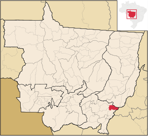
Barra do Garças
Municipality in Central-West, Brazil
Distance: Approx. 4 meters
Latitude and longitude: -15.89,-52.25666667
Barra do Garças is a city with a population of 61,135 located in the Brazilian state of Mato Grosso, around 550 km (340 mi) from the capital city of Cuiabá. It was founded on 13 June 1924, but it became politically independent on the 15th of September 1948. Nowadays, Barra do Garças is the 8th biggest city in Mato Grosso.

Aragarças
Municipality in Central-West, Brazil
Distance: Approx. 2105 meters
Latitude and longitude: -15.9025,-52.24194444
Aragarças is a municipality in southwest Goiás state, Brazil.

Microregion of Aragarças
Microregion in Goiás, Brazil
Distance: Approx. 1070 meters
Latitude and longitude: -15.89777778,-52.25083333
The Aragarças Microregion is a geographical division in Goiás state, Brazil. It consists of 7 municipalities located around Aragarças in western Goiás.

Roman Catholic Diocese of Barra do Garças
Catholic ecclesiastical territory
Distance: Approx. 1103 meters
Latitude and longitude: -15.8886,-52.2669
The Roman Catholic Diocese of Barra do Garças (Latin: Dioecesis Barragartiensis) is a diocese located in the city of Barra do Garças in the ecclesiastical province of Cuiabá in Brazil.
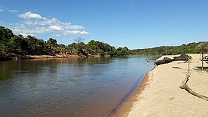
Das Garças River (Mato Grosso)
River in Mato Grosso, Brazil
Distance: Approx. 1324 meters
Latitude and longitude: -15.9,-52.25
The Das Garças River is a river in Mato Grosso state in western Brazil. It is close to the Madeira river.
Pontal do Araguaia
Municipality in Center-West, Brazil
Distance: Approx. 8088 meters
Latitude and longitude: -15.9339,-52.3169
Pontal do Araguaia is a municipality in the state of Mato Grosso in the Central-West Region of Brazil.

Serra Azul State Park
State park in Mato Grosso, Brazil
Distance: Approx. 8831 meters
Latitude and longitude: -15.821,-52.216
The Serra Azul State Park (Portuguese: Parque Estadual da Serra Azul) is a state park in the state of Mato Grosso, Brazil. It protects a mountainous area of cerrado forest and contains slopes that are used for paragliding. The park contains the geodetic center of Brazil.
Weather in this IP's area
few clouds
38 Celsius
38 Celsius
38 Celsius
38 Celsius
1011 hPa
22 %
1011 hPa
978 hPa
7000 meters
3.09 m/s
150 degree
16 %
05:11:07
17:25:48