177.85.237.220 - IP Lookup: Free IP Address Lookup, Postal Code Lookup, IP Location Lookup, IP ASN, Public IP
Country:
Region:
City:
Location:
Time Zone:
Postal Code:
IP information under different IP Channel
ip-api
Country
Region
City
ASN
Time Zone
ISP
Blacklist
Proxy
Latitude
Longitude
Postal
Route
Luminati
Country
Region
sp
City
cachoeirapaulista
ASN
Time Zone
America/Sao_Paulo
ISP
FUNDACAO JOAO PAULO II
Latitude
Longitude
Postal
IPinfo
Country
Region
City
ASN
Time Zone
ISP
Blacklist
Proxy
Latitude
Longitude
Postal
Route
IP2Location
177.85.237.220Country
Region
sao paulo
City
cachoeira paulista
Time Zone
America/Sao_Paulo
ISP
Language
User-Agent
Latitude
Longitude
Postal
db-ip
Country
Region
City
ASN
Time Zone
ISP
Blacklist
Proxy
Latitude
Longitude
Postal
Route
ipdata
Country
Region
City
ASN
Time Zone
ISP
Blacklist
Proxy
Latitude
Longitude
Postal
Route
Popular places and events near this IP address

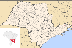
Cachoeira Paulista
Municipality in Southeast Brazil, Brazil
Distance: Approx. 5 meters
Latitude and longitude: -22.665,-45.00944444
Cachoeira Paulista is a municipality in the state of São Paulo in Brazil. It is part of the Metropolitan Region of Vale do Paraíba e Litoral Norte, in the Guaratinguetá Microregion. It is located at latitude 22º39'54 "south and longitude 45º00'34" west, being at an altitude of 521 meters.

Canas, São Paulo
Municipality in the state of São Paulo in Brazil
Distance: Approx. 6378 meters
Latitude and longitude: -22.70361111,-45.05527778
Canas is a municipality in the state of São Paulo in Brazil. It is part of the Metropolitan Region of Vale do Paraíba e Litoral Norte. The population is 5,204 (2020 est.) in an area of 53.26 km².
Bocaina River
River in Brazil
Distance: Approx. 1129 meters
Latitude and longitude: -22.656189,-45.003952
The Bocaina River (Portuguese: Ribeirão Bocaina) is a river of São Paulo state in southeastern Brazil. It is a tributary of the Paraíba do Sul. The headwaters are protected by the 292,000 hectares (720,000 acres) Mananciais do Rio Paraíba do Sul Environmental Protection Area, created in 1982 to protect the sources of the Paraíba do Sul river.

Brazilian Decimetric Array
Radio telescope interferometer based in Brazil
Distance: Approx. 2656 meters
Latitude and longitude: -22.6886,-45.0056
The Brazilian Decimetric Array (BDA) is a 26-element radio telescope interferometer located in the municipality of Cachoeira Paulista in the state of São Paulo, Brazil. It is capable of performing both solar and stellar observations in three bands: 1.2 - 1.7, 2.8 and 5.6 GHz. The BDA will obtain radio images from the sun with a spatial resolution ~4x6 arc seconds.
Weather in this IP's area
overcast clouds
30 Celsius
37 Celsius
30 Celsius
30 Celsius
1012 hPa
83 %
1012 hPa
953 hPa
10000 meters
2.92 m/s
3.89 m/s
193 degree
100 %