Country:
Region:
City:
Latitude and Longitude:
Time Zone:
Postal Code:
IP information under different IP Channel
ip-api
Country
Region
City
ASN
Time Zone
ISP
Blacklist
Proxy
Latitude
Longitude
Postal
Route
Luminati
Country
IPinfo
Country
Region
City
ASN
Time Zone
ISP
Blacklist
Proxy
Latitude
Longitude
Postal
Route
db-ip
Country
Region
City
ASN
Time Zone
ISP
Blacklist
Proxy
Latitude
Longitude
Postal
Route
ipdata
Country
Region
City
ASN
Time Zone
ISP
Blacklist
Proxy
Latitude
Longitude
Postal
Route
Popular places and events near this IP address
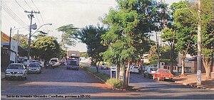
Paulínia
Municipality in the state of São Paulo in Brazil
Distance: Approx. 970 meters
Latitude and longitude: -22.76111111,-47.15416667
Paulínia is a Brazilian municipality in the interior of the state of São Paulo. It is located in the northwest of the São Paulo Macrometropolis and is about 119 km from the state capital. It occupies an area of 139 km2 and in 2018, IBGE estimated its population at 106,776.
Betel (district of Paulínia)
Distance: Approx. 6047 meters
Latitude and longitude: -22.78775278,-47.11190833
Betel is a district of Paulínia, located 5 km to the East of Paulínia downtown, bordering the Campinas district of Barão Geraldo. Its area is about 49.5 km2 and it had a population of 6,242 at the time of the 2010 IBGE census. In 1993, the region was part of the district of Barão Geraldo in Campinas.
São José, Paulínia
Distance: Approx. 3874 meters
Latitude and longitude: -22.72222222,-47.17501944
São José is a neighborhood in the Brazilian city of Paulínia. The city had 12,653 inhabitants as of 2008.

Estádio Municipal Luís Perissinotto
Distance: Approx. 966 meters
Latitude and longitude: -22.76114444,-47.15440556
Estádio Municipal Luiz Perissinotto, usually known as Estádio Luiz Perissinotto or, sometimes by its nicknames Bermudas and Municipal, is a multi-use stadium in Paulínia, Brazil. It is currently used mostly for football matches. The stadium has a capacity of 10,070 people.

Das Pedras River (Anhumas River tributary)
River in Brazil
Distance: Approx. 4152 meters
Latitude and longitude: -22.75,-47.11666667
The Das Pedras River is a river of São Paulo state in southeastern Brazil. It is a tributary of the Anhumas River.
Rodovia Doutor Roberto Moreira
Distance: Approx. 1817 meters
Latitude and longitude: -22.75903889,-47.14064444
Rodovia Doutor Roberto Moreira (official designation PLN-010, also known as Estrada da Rhodia) is a highway in the state of São Paulo, Brazil. Just 19 km long, this double-lane highway has a high traffic within the urban zones of Paulínia. Is maintained by the Paulínia City Hall.
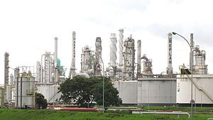
Refinaria do Planalto Paulista
Distance: Approx. 3766 meters
Latitude and longitude: -22.72833333,-47.13166667
Refinaria de Paulínia or simply REPLAN is a petroleum refinery located in the city of Paulínia in the São Paulo state, in Brazil. REPLAN is the largest refinery of the Brazilian company Petrobras, with a capacity of about 360,000 barrels per day (57,000 m3/d), which accounts for about 20% of Brazilian overall petroleum refining capacity. About 80% of the processed petroleum is produced in Brazil, mostly from the Campos Basin.

Mata de Santa Genebra
Distance: Approx. 8941 meters
Latitude and longitude: -22.821176,-47.111295
Mata de Santa Genebra (Saint Geneva Forest) is an area of relevant ecological interest in the state of São Paulo, Brazil.
Anhumas River
River in Brazil
Distance: Approx. 4152 meters
Latitude and longitude: -22.75,-47.11666667
The Anhumas River is a river of São Paulo state in southeastern Brazil.
Weather in this IP's area
overcast clouds
21 Celsius
21 Celsius
21 Celsius
21 Celsius
1012 hPa
73 %
1012 hPa
948 hPa
10000 meters
3.86 m/s
7.91 m/s
144 degree
89 %
05:15:53
18:33:10


