Country:
Region:
City:
Latitude and Longitude:
Time Zone:
Postal Code:
IP information under different IP Channel
ip-api
Country
Region
City
ASN
Time Zone
ISP
Blacklist
Proxy
Latitude
Longitude
Postal
Route
Luminati
Country
ASN
Time Zone
America/Sao_Paulo
ISP
V tal
Latitude
Longitude
Postal
IPinfo
Country
Region
City
ASN
Time Zone
ISP
Blacklist
Proxy
Latitude
Longitude
Postal
Route
db-ip
Country
Region
City
ASN
Time Zone
ISP
Blacklist
Proxy
Latitude
Longitude
Postal
Route
ipdata
Country
Region
City
ASN
Time Zone
ISP
Blacklist
Proxy
Latitude
Longitude
Postal
Route
Popular places and events near this IP address

Alta Floresta
Municipality in Center-West, Brazil
Distance: Approx. 1181 meters
Latitude and longitude: -9.88611111,-56.08722222
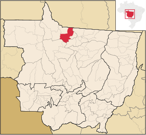
Alta Floresta (Portuguese for "High Forest") is a municipality in Mato Grosso, Brazil. It is located at around 9°53′10″S 56°5′14″W. The municipality is served by Piloto Osvaldo Marques Dias Airport. The municipality contains a small part of the 184,900 hectares (457,000 acres) Cristalino State Park, created in 2001.

Alta Floresta Airport
Airport in Brazil
Distance: Approx. 2311 meters
Latitude and longitude: -9.86638889,-56.105
Piloto Osvaldo Marques Dias Airport (IATA: AFL, ICAO: SBAT) is the airport serving Alta Floresta, Brazil. It is operated by Aeroeste.
Weather in this IP's area
overcast clouds
27 Celsius
29 Celsius
27 Celsius
27 Celsius
1012 hPa
71 %
1012 hPa
979 hPa
10000 meters
1.45 m/s
2.05 m/s
81 degree
92 %
05:12:12
17:47:48