Lookup
Country:
 Brazil
Region:
go
City:
itapirapuã
Latitude and Longitude:
-15.823300,-50.613300
Time Zone:
America/Sao_Paulo
Postal Code:
IP information under different IP Channel
ip-api
Country
Region
City
ASN
Time Zone
ISP
Blacklist
Proxy
Latitude
Longitude
Postal
Route
IPinfo
Country
Region
City
ASN
Time Zone
ISP
Blacklist
Proxy
Latitude
Longitude
Postal
Route
MaxMind
Country
Region
City
ASN
Time Zone
ISP
Blacklist
Proxy
Latitude
Longitude
Postal
Route
Luminati
Country
BRRegion
ms
City
dourados
ASN
Time Zone
America/Campo_Grande
ISP
V tal
Latitude
-22.1437
Longitude
-54.8047
Postal
79800
db-ip
Country
Region
City
ASN
Time Zone
ISP
Blacklist
Proxy
Latitude
Longitude
Postal
Route
ipdata
Country
Region
City
ASN
Time Zone
ISP
Blacklist
Proxy
Latitude
Longitude
Postal
Route
Popular places and events near this IP address
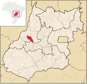
Itapirapuã
Municipality in Central-West, Brazil
Distance: Approx. 1336 meters
Latitude and longitude: -15.82583333,-50.60111111
Itapirapuã is a municipality in the state of Goiás in Brazil. The population is 4,685 (2020 est.) in an area of 2,044 km2. Itapirapuã is a large producer of cattle.
Weather in this IP's area
Current Weather
few clouds
Current Temperature
31 Celsius
Feeling temperature
29 Celsius
lowest temperature
31 Celsius
Maximum temperature
31 Celsius
Atmospheric pressure
1007 hPa
humidity
19 %
Sea level pressure
1007 hPa
Surface atmospheric pressure
969 hPa
visibility
10000 meters
Wind speed
1.08 m/s
gust
1.19 m/s
wind direction
96 degree
cloud
19 %
Sunrise time
06:04:34
Sunset time
18:19:13