Country:
Region:
City:
Latitude and Longitude:
Time Zone:
Postal Code:
IP information under different IP Channel
ip-api
Country
Region
City
ASN
Time Zone
ISP
Blacklist
Proxy
Latitude
Longitude
Postal
Route
Luminati
Country
Region
ms
City
pontapora
ASN
Time Zone
America/Campo_Grande
ISP
V tal
Latitude
Longitude
Postal
IPinfo
Country
Region
City
ASN
Time Zone
ISP
Blacklist
Proxy
Latitude
Longitude
Postal
Route
db-ip
Country
Region
City
ASN
Time Zone
ISP
Blacklist
Proxy
Latitude
Longitude
Postal
Route
ipdata
Country
Region
City
ASN
Time Zone
ISP
Blacklist
Proxy
Latitude
Longitude
Postal
Route
Popular places and events near this IP address

Arenápolis
Municipality in Center-West, Brazil
Distance: Approx. 3693 meters
Latitude and longitude: -14.43333333,-56.81666667
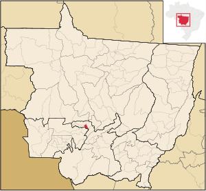
Arenápolis is a Brazilian municipality in the state of Mato Grosso. It is situated at a latitude of 14°27'01" south and a longitude of 56°50'46" west, at an altitude of 247 meters, making it the closest city to the South American continental pole of inaccessibility. The estimated population in 2021 was 9,399 inhabitants, covering an area of 417.337 km².

Nortelândia
Municipality in Center-West, Brazil
Distance: Approx. 4697 meters
Latitude and longitude: -14.455,-56.8028
Nortelândia is a municipality in the state of Mato Grosso in the Central-West Region of Brazil.
Weather in this IP's area
broken clouds
34 Celsius
38 Celsius
34 Celsius
34 Celsius
1011 hPa
47 %
1011 hPa
985 hPa
10000 meters
1.24 m/s
2.74 m/s
353 degree
84 %
05:08:20
17:57:45