Country:
 Mexico
Region:
City:
Latitude and Longitude:
Time Zone:
Postal Code:
IP information under different IP Channel
ip-api
Country
Region
City
ASN
Time Zone
ISP
Blacklist
Proxy
Latitude
Longitude
Postal
Route
IPinfo
Country
Region
City
ASN
Time Zone
ISP
Blacklist
Proxy
Latitude
Longitude
Postal
Route
MaxMind
Country
Region
City
ASN
Time Zone
ISP
Blacklist
Proxy
Latitude
Longitude
Postal
Route
Luminati
Country
MXRegion
agu
City
aguascalientes
ASN
Time Zone
America/Mexico_City
ISP
Cablevision Red, S.A de C.V.
Latitude
Longitude
Postal
db-ip
Country
Region
City
ASN
Time Zone
ISP
Blacklist
Proxy
Latitude
Longitude
Postal
Route
ipdata
Country
Region
City
ASN
Time Zone
ISP
Blacklist
Proxy
Latitude
Longitude
Postal
Route
Popular places and events near this IP address

Aguascalientes (city)
City in the Mexican state of Aguascalientes
Distance: Approx. 5636 meters
Latitude and longitude: 21.876,-102.296
Aguascalientes (Spanish pronunciation: [ˌaɣwaskaˈljentes] , lit. "hot waters" in Spanish) is the capital of the Mexican state of the same name and its most populous city, as well as the head of the Aguascalientes Municipality; with a population of 948,990 inhabitants in 2012 and 1,225,432 in the metro area. The metropolitan area also includes the municipalities of Jesús María and San Francisco de los Romo.

Estadio Victoria
Mexican football Aguascalientes
Distance: Approx. 3823 meters
Latitude and longitude: 21.88055556,-102.27555556
Estadio Victoria is sports stadium in the Mexican city of Aguascalientes, Aguascalientes. The stadium opened in 2003 and has a capacity of 23,000 seats. Although the stadium is capable of multi-use, its main use is for soccer games.

José Guadalupe Posada Museum
Distance: Approx. 5292 meters
Latitude and longitude: 21.87537,-102.29274
The José Guadalupe Posada Museum is located in the Mexican city of Aguascalientes, capital of the State of Aguascalientes, and birthplace of the graphic artist José Guadalupe Posada. The museum displays the original signed printed plates with which he created his graphic images.
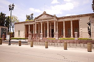
Aguascalientes Museum
Building
Distance: Approx. 5537 meters
Latitude and longitude: 21.885881,-102.291245
The Aguascalientes City Museum (Spanish: Museo de Aguascalientes) is the premier art museum in the city of Aguascalientes in the state of Aguascalientes, Mexico.
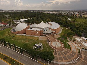
Museo Descubre
Distance: Approx. 4865 meters
Latitude and longitude: 21.856639,-102.289238
Museo Descubre (Full name: "Descubre, Museo Interactivo de Ciencia y Tecnología" or "Discover Interactive Museum of Science and Technology") is a hands-on, interactive museum located in the city of Aguascalientes City, Aguascalientes, Mexico. Inside, the museum is shaped like a spiral, leading inward to various paths of knowledge. The museum creates a link between fun and learning by allowing visitors to actively participate by touching and playing with exhibits.
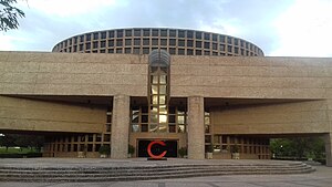
Teatro Aguascalientes
Building
Distance: Approx. 5066 meters
Latitude and longitude: 21.8571,-102.2913
The Teatro Aguascalientes or Aguascalientes Opera House is a theater which functions as the main opera house of the city of Aguascalientes in Mexico. The modern-style building is the work of the architect Abraham Zabludowsky and features a majestic stage and an audience capacity of 1,650. This theater opened its doors to the public on August 16, 1991, with the performance of an operetta.
Parque de Béisbol Alberto Romo Chávez
Stadium in Mexico
Distance: Approx. 3667 meters
Latitude and longitude: 21.88,-102.27416667
Parque de Béisbol Alberto Romo Chávez (English: Alberto Romo Chavez Baseball Park) is a stadium in Aguascalientes, Mexico. It is primarily used for baseball, and is the home field of the Rieleros de Aguascalientes Mexican League baseball team. It holds 6,496 people and was built in 1938.
Centro Escolar el Encino
School
Distance: Approx. 3159 meters
Latitude and longitude: 21.887398,-102.260813
Centro Escolar El Encino is a school in Aguascalientes, Mexico. It is a private school . It has 3 academic levels: Primary, Middle School and High School.
Timeline of Aguascalientes City
Distance: Approx. 5636 meters
Latitude and longitude: 21.876,-102.296
The following is a timeline of the history of Aguascalientes City, Mexico.

Castillo Douglas
House in Aguascalientes, Mexico
Distance: Approx. 5459 meters
Latitude and longitude: 21.8855,-102.2906
Castillo Ortega-Douglas (English: Ortega-Douglas Castle), also known as Castillo Douglas, is a castle-like house in central Aguascalientes, Aguascalientes, Mexico. Designed by Federico Mariscal and supervised by J. Refugio Reyes Rivas, it was built for Edmundo Ortega Douglas, whose maternal grandfather, John Douglas (1849–1918), had emigrated to Mexico from Scotland. The house is notable for having the features of a medieval castle, including a moat, a drawbridge, battlements, turrets, and a stained glass window.
Norias de Ojocaliente, Aguascalientes
Locality in Aguascalientes, Mexico
Distance: Approx. 3925 meters
Latitude and longitude: 21.8893,-102.216
Norias de Ojocaliente is an inhabited place around an ejido in the state of Aguascalientes. It is located 5 miles east of the city of Aguascalientes and has a population of 3,741.
Norias del Paso Hondo, Aguascalientes
Town in Aguascalientes, Mexico
Distance: Approx. 3882 meters
Latitude and longitude: 21.8578,-102.206
Norias del Paso Hondo is a town in the state of Aguascalientes, Mexico. It is located 6 miles east-southeast of the city of Aguascalientes and has a population of 2,539.
Weather in this IP's area
broken clouds
15 Celsius
16 Celsius
15 Celsius
15 Celsius
1013 hPa
94 %
1013 hPa
811 hPa
10000 meters
3.09 m/s
310 degree
75 %
06:42:11
18:30:47